Finsbury
Finsbury is a district of Central London, forming the south-eastern part of the London Borough of Islington.
| Finsbury | |
|---|---|
 Finsbury Location within Greater London | |
| OS grid reference | TQ315825 |
| London borough | |
| Ceremonial county | Greater London |
| Region | |
| Country | England |
| Sovereign state | United Kingdom |
| Post town | LONDON |
| Postcode district | EC1 |
| Postcode district | WC1 |
| Dialling code | 020 |
| Police | Metropolitan |
| Fire | London |
| Ambulance | London |
| UK Parliament | |
| London Assembly | |
Finsbury was a manor which give its name to two much larger administrative areas: Finsbury Division of the Ossulstone Hundred of Middlesex, from the 17th century until 1900 and its successor until 1965 in a small part of its southern area, the Metropolitan Borough of Finsbury.
The area should not be confused with Finsbury Park, a public space roughly three miles to the north and which gives its name to its surrounding mainly residential area.
Etymology
The name is first recorded as Vinisbir (1231) and means "manor of a man called Finn".[1]
Geography
The area lies immediately north of the City of London, and approximates to the part of the London Borough of Islington east of Goswell Street and south of City Road. It also includes a small area north of City Road, focused on the City Road Basin
The parts of the City of London's Coleman Street Ward that lie outside the line of the former City walls (now mostly covered by Finsbury Circus) were historically part of the Manor of Finsbury and still sometimes described as part of the area.
Finsbury Town Hall and the Finsbury Estate lie further west, in Clerkenwell and are named after the former borough of Finsbury which included both Finsbury and Clerkenwell.
Origins and administration
In the Middle Ages, the manor of Finsbury was part of the great fen which lay outside the northern wall of the City of London.[2] It gave its name to the Finsbury division of the Ossulstone hundred of Middlesex.
Manor and parishes
The Manor (estate) of Finsbury was served by the Ancient Parish of St Giles-without-Cripplegate.[3] The manor house, Finsbury Court, lay on the junction of Chiswell Street and Finsbury Pavement. The parish of St Giles-without-Cripplegate also covered an extra-mural part of the City of London known as Cripplegate Without. In the 17th Century, Little and Lower Moorfields, previously in the Manor of Finsbury and Parish of St Giles, was transferred to the Coleman Street Ward of the City of London (and also to the parish of St Stephen Coleman Street for religious purposes). This meant that Coleman Street Ward also possessed an extra-mural area.[4][5]
The estate was made over for the use of the Lord Mayor of London, by Richard II, in gratitude for the killing of Wat Tyler by Mayor William Walworth at Smithfield. After that the formal title of the Mayors has been Mayor of London and Lord of Finsbury.[6]
In 1733, the growth of the local population, led to the part of St Giles-without-Cripplegate outside the City, the area which had been the Manor of Finsbury, being made an independent parish, known as St Luke's, after the parish church.
Recent administration
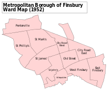
The Metropolitan Borough of Finsbury in the County of London was created in 1900, covering the area of Finsbury and Clerkenwell, with Finsbury Town Hall located on Rosebery Avenue, Clerkenwell. In 1938, Dr. Chuni Lal Katial was elected mayor of Finsbury, making him the first Asian mayor in the United Kingdom.
In 1942 the borough council erected a controversial bust of Vladimir Lenin at the site of a new block of flats in Holford Square (the bust was removed in the 1950s). The borough was abolished in 1965 and absorbed into the borough of Islington.
In 1832 the parliamentary borough of Finsbury was created, covering a considerably wider area. In 1857 Finsbury Park was opened some three miles north, for the enjoyment of the residents of this parliamentary borough.[1]
In 1965 the area was absorbed into the new London Borough of Islington, though Finsbury Circus remains part of the City of London.
History
Growth
Urbanisation was slow, despite the building of a new gate in the adjacent London Wall, Moorgate, in 1511. In 1665 the Bunhill Fields burial ground was opened in the area.
Building on Finsbury Fields began in the late 17th century. The parish church of St Luke's was built in 1732–33, development was accelerated by the building of the City Road in 1765, and at the end of the 18th century a residential suburb was built with its centre at Finsbury Square.[2] Little and Lower Moorfields remained open until Finsbury Circus was developed after 1815.
Military history

In 1641 the Honourable Artillery Company moved to Finsbury, where it still remains. The City of London Yeomanry, founded at the time of the Second Boer War, made its headquarters in Finsbury Square.
In 1862 Finsbury gave its name to a volunteer infantry unit — the Finsbury Rifles, which recruited in both Finsbury and Clerkenwell, and saw distinguished service in several conflicts.
Medical district
Before Harley Street rose to prominence, Finsbury was London’s principal medical district. In the mid-19th century it was home to a large number of hospitals,[7] but now only Moorfields Eye Hospital remains.
The area included the following hospitals:
- Royal Hospital for Diseases of the Chest
- Royal London Opthalmic Hospital (Moorfields)
- St Luke's Hospital for Lunatics
- French Huguenot Hospital
- St Mark's Hospital for Fistula and other Diseases of the Rectum
- Holborn & Finsbury Poor Law Union
- Bethlem Hospital, on the site of what is now Finsbury Circus
Famous residents
- George Cruikshank, the Victorian illustrator, lived on Amwell Street
- Charles Gordon, cricketer and grandson of the founder of Gordon's Gin
- Violet Kray, mother of the gangster Kray brothers. Twins Ronnie and Reggie were arrested at her flat in Braithwaite House, Finsbury, in connection with gangland crimes including murder and fraud on 8 May 1968.[8]
- Eric Maxon, Shakespearean and early film actor, died in Finsbury
- Arthur Mullard, comic actor
- Dadabhai Naoroji, Indian politician
- Susanna Moodie, née Strickland, renowned Canadian writer, abolitionist, early feminist, lived the life of a ‘bluestocking’ in Middleton Square, Finsbury district, London for 3 exhilarating months in 1832. That same year Susanna with her husband John Moodie and firstborn baby daughter emigrated to what was then known as Upper Canada in British North America, travelling through regions along the St. Lawrence, today known as the Greater Toronto Area, Cobourg, Port Hope) settling in the Peterborough area north of what was then known as York ( renamed Toronto in the province of Ontario, Canada.)
See also
References
- Mills, D. (2000). Oxford Dictionary of London Place Names. ISBN 0-19-860957-4.
- Weinreb, B. and Hibbert, C. (eds.) (1983) The London Encyclopaedia. Macmillan ISBN 0-333-57688-8
- Records of St Giles without Cripplegate, Chapter 6 see https://archive.org/stream/recordsstgilesc01dentgoog/recordsstgilesc01dentgoog_djvu.txt
- The development of Moorfields [London], the historical background’, in Reclaiming the Marsh: Archaeological excavations at Moor House, City of London, 1998-2004 (ed. J Butler), PCA Monograph 6 (London)
- Stow, writing in 1603 describes the boundaries of Cripplegate and Coleman Street Wards and the area is in neither at that time. The Ogilby and Morgan Map of 1676 shows the Little and Lower Moorfields as part of Coleman Street Ward
- Online dictionary of heraldry https://www.heraldryclipart.com/dictionary/dm.html
- Black, Nick (2007). "The lost hospitals of St Luke's". Journal of the Royal Society of Medicine. 100 (3): 125–129. PMC 1809165.
External links
- . Encyclopædia Britannica (11th ed.). 1911.
| Districts |  | |
|---|---|---|
| Attractions |
| |
| Street markets | ||
| Parks and open spaces |
| |
| Constituencies | ||
| Tube and rail stations | ||
| Other topics | ||
| ||