Curra, Queensland
Curra is a locality in the Gympie Region, Queensland, Australia.[2] At the 2016 census, Curra had a population of 1,920.[1]
| Curra Queensland | |||||||||||||||
|---|---|---|---|---|---|---|---|---|---|---|---|---|---|---|---|
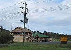 Curra Country Club | |||||||||||||||
 Curra | |||||||||||||||
| Coordinates | 26.0708°S 152.5894°E | ||||||||||||||
| Population | 1,920 (2016 census)[1] | ||||||||||||||
| • Density | 16.80/km2 (43.51/sq mi) | ||||||||||||||
| Postcode(s) | 4570 | ||||||||||||||
| Area | 114.3 km2 (44.1 sq mi) | ||||||||||||||
| Location | |||||||||||||||
| LGA(s) | Gympie Region | ||||||||||||||
| State electorate(s) | Gympie | ||||||||||||||
| Federal Division(s) | Wide Bay | ||||||||||||||
| |||||||||||||||
Geography
Curra is in the Wide Bay–Burnett region of Queensland. It was once part of Shire of Tiaro but is now within the Gympie Region local government area.[2] It also belongs to the non-functional administrative unit known as the County of March. It is situated on the Bruce Highway, north of Gympie. The North Coast railway line passes through the town.[3] The Mary River forms the western boundary, and Curra Creek is part of the northern boundary. To the east of the locality is a large portion of Curra State Forest.
Curra is zoned rural/residential with working pastoral farms and small acreages. Curra is at the northern end of a stretch of the Bruce Highway which starts in the south near Cooroy and is considered to be one of the most dangerous of Queensland roads.[4]
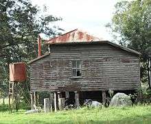
History
.jpg)
Curra (Aboriginal name 'Kurui' means grey forest possum). The local Aboriginal tribe of the Gympie region and the Mary River Valley are the Kabi Tribe of the Kabi Kabi First Nation language group.
Parts of Curra are beside the Mary River (Kabi name 'Monaboola' meaning Wide Bay River, named in 1848 in honour of the wife of Governor Fitzroy who had died in 1847), and the railway to the north.
The first landholder owner was Walter Hay whose cattle station homestead in 1859 was named "Currie" and later changed to Curra.
During the gold rush era starting in 1867, Curra was a stopover depot at Palmer's Stockholm Hotel at the Nine Mile for travellers between Maryborough and Gympie using Cobb & Co coaches.
In 1887, 23,500 acres (9,500 ha) of land were resumed from the Curra pastoral run. The land was offered for selection for the establishment of small farms on 17 April 1887.[5]
Curra School was opened in 1893, established to cater for the increase in population and closed in 1961.[6] There was a mine in the Curra Estate Road area and there is a working limestone quarry.
Curra Post Office opened by 1916 (a receiving office had been open from 1892) and closed in 1977.[7]
At the 2006 census, Curra had a population of 1,372.[8]
Facilities
A peaceful area for families and retirees with facilities such as the rural fire service; parks and playground; a post office box; Matilda service station – with motel accommodation, food and groceries and a discount Pharmacy ; a community club called the Curra Country Club; and a 6 hectare block of land, council approved for hotel/motel and shops. There is an increasing amount of small businesses establishing in this area.
Education
Today, there is a school bus which transports the local school children to the Gympie area.
References
- Australian Bureau of Statistics (27 June 2017). "Curra (State Suburb)". 2016 Census QuickStats. Retrieved 8 November 2017.

- "Curra - locality in Gympie Region (entry 46323)". Queensland Place Names. Queensland Government. Retrieved 6 November 2017.
- "Queensland Globe". State of Queensland. Retrieved 8 November 2017.
- "Cooroy to Curra on death list again". The Bundaberg Newspaper Company. 19 January 2012. Retrieved 21 May 2012.
- "Proclamations under the New Land Acts". The Brisbane Courier. Queensland, Australia. 2 March 1877. p. 3. Retrieved 20 February 2020 – via Trove.
- "Curra". Queensland Places. Centre for the Government of Queensland, University of Queensland. Retrieved 25 May 2012.
- Premier Postal History. "Post Office List". Premier Postal Auctions. Retrieved 10 May 2014.
- Australian Bureau of Statistics (25 October 2007). "Curra (Urban Centre/Locality)". 2006 Census QuickStats. Retrieved 24 May 2012.
- Handmade booklets by Curra Art Group, Curra
External links
![]()
- "Curra". Queensland Places. Centre for the Government of Queensland, University of Queensland.
- Community website