Culaba, Biliran
Culaba, officially the Municipality of Culaba (Waray: Bungto san Culaba; Cebuano: Lungsod sa Culaba; Tagalog: Bayan ng Culaba), is a 5th class municipality in the province of Biliran, Philippines. According to the 2015 census, it has a population of 12,325 people.[5]
Culaba | |
|---|---|
| Municipality of Culaba | |
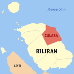 Map of Biliran with Culaba highlighted | |
OpenStreetMap 
| |
.svg.png) Culaba Location within the Philippines | |
| Coordinates: 11°39′28″N 124°32′33″E | |
| Country | |
| Region | Eastern Visayas (Region VIII) |
| Province | Biliran |
| District | Lone district |
| Founded | 16 October 1953 [1] |
| Barangays | 17 (see Barangays) |
| Government | |
| • Type | Sangguniang Bayan |
| • Mayor | Humphrey B. Olimba |
| • Vice Mayor | Enrico B. Uyvico |
| • Congressman | Gerardo J. Espina Jr. |
| • Municipal Council | Councilors
|
| • Electorate | 10,423 voters (2019) |
| Area | |
| • Total | 73.42 km2 (28.35 sq mi) |
| Elevation | 5.0 m (16.4 ft) |
| Population (2015 census)[5] | |
| • Total | 12,325 |
| • Density | 170/km2 (430/sq mi) |
| • Households | 2,716 |
| Economy | |
| • Income class | 5th municipal income class |
| • Poverty incidence | 39.41% (2015)[6] |
| • Revenue (₱) | 52,687,993.64 (2016) |
| Time zone | UTC+8 (PST) |
| ZIP code | 6547 |
| PSGC | |
| IDD : area code | +63 (0)53 |
| Climate type | tropical monsoon climate |
| Native languages | Waray Tagalog |
| Website | www |
Geography
According to the Philippine Statistics Authority, the municipality has a land area of 73.42 square kilometres (28.35 sq mi) [3] constituting 13.70% of the 536.01-square-kilometre- (206.95 sq mi) total area of Biliran.
Barangays
Culaba is politically subdivided into 17 barangays.[7]
| PSGC | Barangay | Population | ±% p.a. | |||
|---|---|---|---|---|---|---|
| 2015[5] | 2010[8] | |||||
| 087805001 | Acaban | 5.0% | 615 | 635 | −0.61% | |
| 087805002 | Bacolod | 2.7% | 331 | 292 | 2.42% | |
| 087805003 | Binongtoan | 6.7% | 827 | 821 | 0.14% | |
| 087805004 | Bool Central (Poblacion) | 4.0% | 494 | 605 | −3.79% | |
| 087805005 | Bool East (Poblacion) | 8.2% | 1,012 | 970 | 0.81% | |
| 087805006 | Bool West (Poblacion) | 6.0% | 745 | 764 | −0.48% | |
| 087805007 | Calipayan | 4.6% | 569 | 578 | −0.30% | |
| 087805008 | Guindapunan | 3.6% | 440 | 429 | 0.48% | |
| 087805009 | Habuhab | 2.7% | 329 | 282 | 2.98% | |
| 087805010 | Looc | 7.0% | 862 | 829 | 0.75% | |
| 087805011 | Marvel (Poblacion) | 14.0% | 1,720 | 1,634 | 0.98% | |
| 087805012 | Patag | 4.0% | 496 | 481 | 0.59% | |
| 087805013 | Pinamihagan | 6.7% | 828 | 905 | −1.68% | |
| 087805014 | Culaba Central (Poblacion) | 5.1% | 625 | 683 | −1.68% | |
| 087805015 | Salvacion | 2.6% | 321 | 328 | −0.41% | |
| 087805016 | San Roque | 4.1% | 509 | 477 | 1.24% | |
| 087805017 | Virginia (Poblacion) | 13.0% | 1,602 | 1,539 | 0.77% | |
| Total | 12,325 | 12,252 | 0.11% | |||
Climate
| Climate data for Culaba, Biliran | |||||||||||||
|---|---|---|---|---|---|---|---|---|---|---|---|---|---|
| Month | Jan | Feb | Mar | Apr | May | Jun | Jul | Aug | Sep | Oct | Nov | Dec | Year |
| Average high °C (°F) | 28 (82) |
29 (84) |
29 (84) |
31 (88) |
31 (88) |
30 (86) |
30 (86) |
30 (86) |
30 (86) |
29 (84) |
29 (84) |
29 (84) |
30 (85) |
| Average low °C (°F) | 22 (72) |
22 (72) |
22 (72) |
23 (73) |
24 (75) |
25 (77) |
25 (77) |
25 (77) |
25 (77) |
24 (75) |
24 (75) |
23 (73) |
24 (75) |
| Average precipitation mm (inches) | 73 (2.9) |
56 (2.2) |
75 (3.0) |
71 (2.8) |
114 (4.5) |
174 (6.9) |
172 (6.8) |
163 (6.4) |
167 (6.6) |
161 (6.3) |
158 (6.2) |
125 (4.9) |
1,509 (59.5) |
| Average rainy days | 15.2 | 12.5 | 16.2 | 17.3 | 23.9 | 27.3 | 28.4 | 26.9 | 26.9 | 27.1 | 23.8 | 19.3 | 264.8 |
| Source: Meteoblue (modeled/calculated data, not measured locally) [9] | |||||||||||||
Demographics
| Population census of Culaba | |||||||||||||||||||||||||||||||||||||
|---|---|---|---|---|---|---|---|---|---|---|---|---|---|---|---|---|---|---|---|---|---|---|---|---|---|---|---|---|---|---|---|---|---|---|---|---|---|
|
| ||||||||||||||||||||||||||||||||||||
| Source: Philippine Statistics Authority[5][8][10][11] | |||||||||||||||||||||||||||||||||||||
In the 2015 census, Culaba had a population of 12,325.[5] The population density was 170 inhabitants per square kilometre (440/sq mi).
Education
Secondary schools
- Culaba National Vocational School
- Bool National High School
Elementary schools
- Acaban Elementary School
- Bacolod Elementary School
- Binongtoan Elementary School
- Bool Elementary School
- Culaba Central School
- Calipayan Elementary School
- Habuhab Elementary School
- Looc Elementary School
- Patag Elementary School
- Pinamihagan Elementary School
- Salvation Elementary School
- San Roque Elementary School
Hospital and Health centers
- Culaba Community Hospital
- Bool Health Center
- Bacolod Health Center
- Pinamihagan Health Center
References
- "Republic Act No. 6488 - An Act Creating Certain Municipalities in the Province of Leyte". Chan Robles Virtual Law Library. Retrieved 5 December 2016.
- "Municipality". Quezon City, Philippines: Department of the Interior and Local Government. Retrieved 31 May 2013.
- "Province: Biliran". PSGC Interactive. Quezon City, Philippines: Philippine Statistics Authority. Retrieved 12 November 2016.
- "Culaba, Biliran Profile". PhilAtlas.com. Retrieved 15 June 2020.
- Census of Population (2015). "Region VIII (Eastern Visayas)". Total Population by Province, City, Municipality and Barangay. PSA. Retrieved 20 June 2016.
- "PSA releases the 2015 Municipal and City Level Poverty Estimates". Quezon City, Philippines. Retrieved 12 October 2019.
- "Municipal: Culaba, Biliran". PSGC Interactive. Quezon City, Philippines: Philippine Statistics Authority. Retrieved 8 January 2016.
- Census of Population and Housing (2010). "Region VIII (Eastern Visayas)". Total Population by Province, City, Municipality and Barangay. NSO. Retrieved 29 June 2016.
- "Culaba: Average Temperatures and Rainfall". Meteoblue. Retrieved 29 February 2020.
- Censuses of Population (1903–2007). "Region VIII (Eastern Visayas)". Table 1. Population Enumerated in Various Censuses by Province/Highly Urbanized City: 1903 to 2007. NSO.
- "Province of Biliran". Municipality Population Data. Local Water Utilities Administration Research Division. Retrieved 17 December 2016.
This article is issued from Wikipedia. The text is licensed under Creative Commons - Attribution - Sharealike. Additional terms may apply for the media files.