City of Casey
The City of Casey is a local government area in Victoria, Australia in the outer south-eastern suburbs of Melbourne. Casey is Victoria's most populous municipality, with a June 2018 population of 340,419.[1] It has an area of 409 square kilometres (157.9 sq mi).
| City of Casey Victoria | |||||||||||||||
|---|---|---|---|---|---|---|---|---|---|---|---|---|---|---|---|
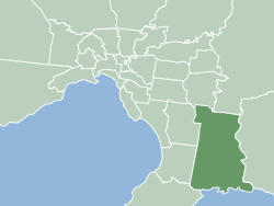 Map of Melbourne showing City of Casey | |||||||||||||||
| Population | 340,419 (2018)[1] (8th) | ||||||||||||||
| • Density | 832.3/km2 (2,155.7/sq mi) | ||||||||||||||
| Established | 1994 | ||||||||||||||
| Area | 409 km2 (157.9 sq mi)[1] | ||||||||||||||
| Council seat | Narre Warren | ||||||||||||||
| Region | Southeast Metropolitan Melbourne | ||||||||||||||
| State electorate(s) | |||||||||||||||
| Federal Division(s) | |||||||||||||||
| Website | City of Casey | ||||||||||||||
| |||||||||||||||
The city is named after Lord Casey, the 16th Governor-General of Australia, and was formed in 1994 by the merger of most of the City of Berwick with parts of Shire of Cranbourne (including Cranbourne itself), and the Churchill Park Drive estate within the City of Knox.[2]
Geography
Casey spreads from the base of the Dandenong Ranges in the north to the shoreline of Western Port in the south. It features a wide variety of geographical features, due to its outer metropolitan location.
The north, in the foothills of the Dandenongs, is primarily made up of large blocks of land used for grazing, with some small vineyards in operation. An Urban Growth Boundary has been in place since 2005 to protect this area from future residential subdivision.
South of Cranbourne is mainly farmland, used for market gardening and grazing. A small number of flower farms exist around Junction Village, along with a large chicken processing plant in Clyde. This green area has now been opened up for housing development, in the areas of Cranbourne East, Clyde and Clyde North.[3]
The southern boundary of the municipality is the Western Port shoreline including the fishing villages of Tooradin, Blind Bight, Warneet and Cannons Creek. Protected marine reserves exist along this coastline and extend into the Mornington Peninsula at Pearcedale.
The Cardinia border of the city is formed for some of the boundary by the Cardinia Creek, which is drained through channels into Western Port at its southern end. The popular Riding of the Bounds event takes place along this border, in recognition of Berwick's sister city status with Berwick-upon-Tweed in Northumberland, England.[4]
City council
The City of Casey is divided into six wards.[5]
Elections are held every four years with voters in Balla Balla Ward electing one councillor and all other wards electing two councillors per ward. The eleven councillors vote each year to elect a mayor.
In February 2020, the Victorian Minister for Local Government Adem Somyurek MP dismissed all Casey Councillors following a report from municipal monitor Laurinda Gardner that found significant governance failures at the council. Somyurek then appointed Noelene Duff as interim Administrator.
In May 2020 Somyurek appointed Noelene Duff PSM, Cameron Boardman and Miguel Belmar as Council administrator panel, to remain until October 2024.
Places of interest
- Akoonah Park
- Casey Insight Education Centre for the Blind and Vision Impaired
- Casey RACE – Recreation & Aquatic Centre
- Casey Aquatic and Recreation Centre (ARC)
- Casey Cardinia Libraries
- Cranbourne Community Theatre
- Casey Fields
- Westfield Fountain Gate
- Lysterfield Lake Park
- Federation University, Berwick Campus
- Moonlit Sanctuary Wildlife Conservation Park
- Myuna Farm
- Royal Botanic Gardens, Cranbourne
- The Factory – Rehearsal Centre for the Arts (Cranbourne)
- The Shed (indoor skate park)
- Wilson Botanic Park
Suburbs and Towns
- Berwick
- Blind Bight
- Botanic Ridge
- Cannons Creek
- Clyde
- Clyde North
- Cranbourne
- Cranbourne East
- Cranbourne North
- Cranbourne South
- Cranbourne West
- Devon Meadows
- Doveton
- Endeavour Hills
- Eumemmerring
- Hallam
- Hampton Park
- Harkaway
- Junction Village
- Lynbrook
- Lyndhurst (shared with the City of Greater Dandenong)
- Lysterfield South
- Narre Warren
- Narre Warren North
- Narre Warren South
- Pearcedale
- Tooradin
- Warneet
Sport
The Casey Demons (formerly Scorpions), an Australian rules football club represent Casey in the Victorian Football League. Their home ground is at the Casey Fields Complex in Cranbourne. The team was founded in around 1903 in Springvale.
The Casey-South Melbourne Cricket Club also have their home ground at Casey Fields.
The Melbourne Football Club has developed a partnership with the City of Casey,[6] with training sessions and other events held at Casey Fields.
Media
Community Radio – 97.7 FM 3SER
Friendship and Sister City Relationships
The City of Casey is twinned with[7]
|
In 1998 the City of Casey established a friendship link (also known as a twin town) with ![]()
See also
Notes
References
- "3218.0 – Regional Population Growth, Australia, 2017-18: Population Estimates by Local Government Area (ASGS 2018), 2017 to 2018". Australian Bureau of Statistics. Australian Bureau of Statistics. 27 March 2019. Retrieved 25 October 2019. Estimated resident population, 30 June 2018.
- Australian Bureau of Statistics (1 August 1995). Victorian local government amalgamations 1994–1995: Changes to the Australian Standard Geographical Classification (PDF). Commonwealth of Australia. p. 7. ISBN 0-642-23117-6. Retrieved 16 December 2007.
- "New development set to provide 21,000 homes in Clyde North". Herald Sun. Herald Sun. 3 March 2014. Retrieved 20 April 2016.
- "Sister Cities". City of Casey. Retrieved 20 April 2016.
- Victorian Electoral Commission (2014). "Casey City Council profile". Retrieved 20 April 2016.
- "Melbourne Football Club - Casey Partnership". Retrieved 20 April 2016.
- "Friendship and Sister city Relationships". City of Casey. Retrieved 6 August 2018.
- http://www.casey.vic.gov.au/council/our-city/sistercities/berwick
- http://www.casey.vic.gov.au/council/our-city/sistercities/springfield
- http://www.casey.vic.gov.au/council/about-casey/sistercities/ermera