Shire of Baw Baw
The Shire of Baw Baw is a local government area in Victoria, Australia, in the eastern part of the state. It covers an area of 4,028 square kilometres (1,555 sq mi) and in June 2018 had a population of 52,015.[1]
| Shire of Baw Baw Victoria | |||||||||||||||
|---|---|---|---|---|---|---|---|---|---|---|---|---|---|---|---|
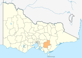 Location in Victoria | |||||||||||||||
| Population | 52,015 (2018)[1] | ||||||||||||||
| • Density | 12.9134/km2 (33.445/sq mi) | ||||||||||||||
| Established | 1994 | ||||||||||||||
| Gazetted | 2 December 1994[2] | ||||||||||||||
| Area | 4,028 km2 (1,555.2 sq mi)[1] | ||||||||||||||
| Mayor | Cr Danny Goss | ||||||||||||||
| Council seat | Warragul | ||||||||||||||
| Region | Eastern Victoria | ||||||||||||||
| State electorate(s) | Narracan | ||||||||||||||
| Federal Division(s) | Monash | ||||||||||||||
| Website | Shire of Baw Baw | ||||||||||||||
| |||||||||||||||

It includes the towns of Drouin, Longwarry, Neerim South, Trafalgar, Warragul and Yarragon. It was formed in 1994 from the amalgamation of the Shire of Buln Buln, Shire of Narracan, Rural City of Warragul, and some parts of the Shire of Upper Yarra.[2]
The Shire is governed and administered by the Baw Baw Shire Council; its seat of local government and administrative centre is located at the council headquarters in Drouin, and it has a service centre located in Warragul. The Shire is named after the major geographical feature in the region, the Baw Baw Plateau with Mount Baw Baw being the second highest peak in the region. A small alpine ski resort on the mountain is an unincorporated area forming an enclave surrounded by the Shire.
Location and geography
The more densely populated southern half of the Shire consists of low rolling hills given over primarily to dairy farming and other agriculture. The northern half lies in the Great Dividing Range and its foothills, where forestry remains an important industry. Tourism is also important in the region, aided by its proximity to and easy access from Melbourne. The shire is known for its rural scenery and natural environment, as well as gourmet foods and wines. The historic gold-mining town of Walhalla is located in the northeast of the shire is a major tourist drawcard. The major electricity-producing region of the Latrobe Valley lies immediately to the shire's east and south.
Many of the Shire's larger towns are located along the Princes Highway and main Gippsland Railway line, which cross the southern part of the shire. From west to east these include: Longwarry, Drouin, Warragul, Darnum, Yarragon, and Trafalgar. North of Warragul are Buln Buln, Neerim South, and Noojee, while south of Trafalgar in the Strzelecki Ranges lies the town of Thorpdale. The towns of Rawson, Erica, and Parkers Corner are located near Walhalla amongst the foothills of the Baw Baw Plateau. Aberfeldy is located in the far north east of the shire above the Thomson Dam, which supplies 50% of Melbourne's water.
Council
Composition up to November 2016
The council was composed of four wards and nine councillors, with three councillors elected to represent the Warragul Ward and two councillors per remaining ward elected to represent each of the other wards.[3]
| Ward | Councillor | Notes | ||
|---|---|---|---|---|
| Drouin | Tricia Jones | |||
| Terry Williamson | ||||
| Mount Worth | Murray Cook | Mayor 2012-2014 | ||
| Peter Kostos | ||||
| North | David Balfour | |||
| Deborah Brown | Mayor 2014-2015 | |||
| Warragul | Joe Gauci | Mayor 2015-2016 | ||
| Gerard Murphy | ||||
| Mikaela Power | ||||
Current composition
The council was changed to a three-ward structure with three councillors per ward, with the new council sworn in on 2 November 2016. The new wards are West (primarily Drouin with some rural areas north/south), Central (Warragul) and East.
| Ward | Councillor | Party | Notes | |
|---|---|---|---|---|
| West | Tricia Jones | |||
| Keith Cook | ||||
| Jessica O'Donnell | Labor[4] | |||
| East | Darren Wallace | |||
| Peter Kostos | ||||
| Michael Leaney | ||||
| Cemtral | Joe Gauci | |||
| Danny Goss | ||||
| Mikaela Power | ||||
Administration and governance
The council meets in the council chambers in Trafalgar (former Shire of Narracan). The council's administrative activities are centred in Drouin in the former offices of the Buln Buln Shire. It also provides customer services at both Warragul and the council offices in Drouin. Service centres in Trafalgar and on Smith Street in Warragul were closed in 2015.[5] The council chambers moved to Trafalgar in March 2017 as the Warragul chambers were consumed as part of the renovations for the West Gippsland Arts Centre.
Localities
|
|
|
|
|
See also
- List of localities (Victoria)
- List of reduplicated Australian place names
- Local government in Australia
References
- "3218.0 – Regional Population Growth, Australia, 2017-18: Population Estimates by Local Government Area (ASGS 2018), 2017 to 2018". Australian Bureau of Statistics. Australian Bureau of Statistics. 27 March 2019. Retrieved 25 October 2019. Estimated resident population, 30 June 2018.
- Victoria Government Gazette – Online Archive (1837–1997). "S94 of 1994: Order estg (Part 3) the Shire of Baw Baw". State Library of Victoria. State Government of Victoria (published 2 December 1994). p. 2. Retrieved 10 January 2014.
- Local Government in Victoria. "Baw Baw Shire Council". Department of Transport, Planning and Local Infrastructure. State Government of Victoria. Retrieved 10 January 2014.
- http://thegazette.com.au/2019/05/21/broadbent-re-elected/
- "Customer Service Centre Locations". Baw Baw Shire. Baw baw Shire. Retrieved 20 April 2016.