Chunarughat Upazila
Chunarughat (Bengali: চুনারুঘাট) is an Upazila of Habiganj District[1] in the Division of Sylhet, Bangladesh.
Chunarughat চুনারুঘাট | |
|---|---|
Upazila | |
 Chunarughat Location in Bangladesh | |
| Coordinates: 24°12.5′N 91°31.3′E | |
| Country | |
| Division | Sylhet Division |
| District | Habiganj District |
| Area | |
| • Total | 495.52 km2 (191.32 sq mi) |
| Population (1991) | |
| • Total | 233,752 |
| • Density | 470/km2 (1,200/sq mi) |
| Demonym(s) | Chunarughati |
| Time zone | UTC+6 (BST) |
| Website | chunarughat |
Geography
Chunarughat is located at 24.2083°N 91.5222°E. It has 43660 households and total area 495.52 km².
History

Rajapur (Tekarghat) in Chunarughat was the capital of the Hindu kingdom of Tungachal. Raja Achak Narayan was its final Hindu ruler who was defeated in the Capture of Taraf in 1304. Tungachal was renamed Taraf and its first Muslim ruler was Syed Nasiruddin, who is buried in the famous Murarband Dargah Sharif.[2][3] Syed Shah Israil wrote the Persian book Ma'dan al-Fawaid in 1534, is considered to be Sylhet's first author.[4] The Battle of Jilkua took place in Chunarughat in 1581 between the Taraf and Twipra kingdoms. The Khowai River was the only mode of transport and communication with other places. A ghat was situated in the river's western bank in the Borail mauza. A famous lime (known as chun in Bengali) trader had a business at the ghat which was famed throughout Taraf. Thus, the name came to be known as Chunarughat. In 1914, the Chunarughat thana was established. During the Bangladesh Liberation War of 1971, a mass killing was orchestrated in Nalua Tea Garden. Chunarughat Thana was upgraded to an upazila in 1983. There is now a memorial monument in Chunarughat.[1]
Demographics
As of the 1991 Bangladesh census, Chunarughat has a population of 233752. Males constitute 50.2% of the population, and females 49.8%. This Upazila's eighteen up population is 119571. Chunarughat has an average literacy rate of 49.2% (7+ years), and the national average of 32.4% literate.[5]
Administration
Chunarughat has one pourashava & 10 Unions/Wards, 165 Mauzas/Mahallas, and 377 villages. The unions are:
- Gazipur
- Ahmadabad
- Deorgachh
- Paikpara
- Shankhola
- Chunarughat
- Ubahata
- Shatiajuri
- Ranigaon
- Mirashi
Notable people
- Mamun Chowdhury, British businessman
- M. A. Rashid, Vice-Chancellor of East Pakistan University of Engineering and Technology
- Syed Nasiruddin, Sipahsalar for Shamsuddin Firuz Shah
- Syed Shah Israil, Sylhet's first author
See also
- Upazilas of Bangladesh
- Districts of Bangladesh
- Divisions of Bangladesh
References
- Jayanta Singh Roy (2012). "Chunarughat Upazila". In Islam, Sirajul; Miah, Sajahan; Khanam, Mahfuza; Ahmed, Sabbir (eds.). Banglapedia: the National Encyclopedia of Bangladesh (Online ed.). Dhaka, Bangladesh: Banglapedia Trust, Asiatic Society of Bangladesh. ISBN 984-32-0576-6. OCLC 52727562. Retrieved 26 June 2020.
- Songbad, Daily Sylheter (17 November 2015). "প্রাচীন তরফ রাজ্যের সংক্ষিপ্ত ইতিবৃত্ত" (in Bengali).
- "মুড়ারবন্দ তরফ রাজ্যের প্রথম রাজধানী ও সৈয়দ বংশের উৎসস্থল" (in Bengali).
- Maulana Abdullah ibn Saeed Jalalabadi (May 2010). "জীবন-গাঙের বাঁকে বাঁকে-(২)" [Curling through the River of Life (2)] (in Bengali). Al Kawsar. Retrieved 1 May 2019.
- "Population Census Wing, BBS". Archived from the original on 2005-03-27. Retrieved November 10, 2006.
Capital: Habiganj | ||
| Upazilas | ||
| Constituencies | ||
| Attractions and sites | ||
| Rivers | ||
| Educational institutions | ||
| History | ||
| Transport | ||
Capital: Sylhet | ||
| Habiganj District | 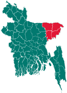 | |
| Moulvibazar District | ||
| Sunamganj District | ||
| Sylhet District | ||