Lubec, Maine
Lubec (/luːˈbɛk/ loo-BEK) is a town in Washington County, Maine, United States. The population was 1,359 at the 2010 census.[4] Lubec is the easternmost town in the contiguous United States (see Extreme points of the United States) and is the closest continental location to Africa in the United States.[5]
Lubec, Maine | |
|---|---|
 West Quoddy Head Lighthouse and Quoddy Narrows, with Grand Manan Island, Canada, in background | |
 Lubec, Maine Location in the state of Maine | |
| Coordinates: 44°50′27″N 67°0′56″W | |
| Country | |
| State | |
| County | Washington |
| Incorporated | 1811 |
| Area | |
| • Total | 78.38 sq mi (203.00 km2) |
| • Land | 33.25 sq mi (86.12 km2) |
| • Water | 45.13 <-- Population --> sq mi (116.89 km2) |
| Elevation | 62 ft (19 m) |
| Population | |
| • Total | 1,359 |
| • Estimate (2012[3]) | 1,336 |
| • Density | 40.9/sq mi (15.8/km2) |
| Time zone | UTC-5 (Eastern (EST)) |
| • Summer (DST) | UTC-4 (EDT) |
| ZIP Code | 04652 |
| Area code(s) | 207 |
| FIPS code | 23-41610 |
| GNIS feature ID | 0582570 |
| Website | townoflubec |
The town is home to Quoddy Head State Park.
History
Located on a peninsula overlooking an excellent ice-free harbor, the town was first settled about 1775. Originally part of Eastport, it was set off and incorporated on June 21, 1811, and named for Lübeck, Germany.[6] Following the War of 1812, Lubec was the site of considerable smuggling trade in gypsum, although principal industries remained agriculture and fisheries. By 1859, there was a tannery, three gristmills and nine sawmills; by 1886, there were also two shipyards, three boatbuilders and three sailmakers.[7]
From 1897 to 1898, the town was the site of a swindle in the sale of stock in the Electrolytic Marine Salts Company, the brainchild of Reverend Prescott Jernegan and Charles Fisher of Martha's Vineyard.[8] Jernegan claimed to have developed a method of using "accumulators" to get gold from sea water, and bought an old grist mill to turn it into a factory. The scheme attracted an abundance of investors, who were all too eager to funnel money into the company after being promised astronomical returns. In the summer of 1898, work was suspended without explanation at the factory. Jernegan and Smith vanished, and the fraud was gleefully exposed by newspapers across New England.[8]
Lubec reached its population peak in the 1910s and 20s, hovering a little above 3,300 during this era. Since then, the population has generally been in a gradual but steady decline, and currently sits at a little over 1,300.
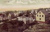 General view c. 1910
 War monument in 1908
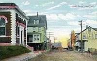 Bank Square c. 1908
 Lubec in 1973
Geography
Lubec is located in northeastern Maine, at 44°51′38″N 66°59′5″W.[9]
According to the United States Census Bureau, the town has a total area of 78.38 square miles (203.00 km2), of which, 33.25 square miles (86.12 km2) of it is land and 45.13 square miles (116.89 km2) is water.[1] Lubec is located on a peninsula in Passamaquoddy Bay, slightly south of Eastport. The West Quoddy Head is southeast.
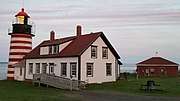
Lubec is the easternmost town of the contiguous United States.[10] West Quoddy Head in Lubec is the easternmost point in the contiguous United States, located at 44°48′54″N 66°57′1″W longitude. It is adjacent to the Quoddy Narrows, a narrow strait between Canada and the United States, one of the entrances into Passamaquoddy Bay. Since 1808, West Quoddy Head Lighthouse has been on the site to guide ships through this waterway. The present lighthouse with its distinctive red-and-white stripes was built in 1858.
Lubec is crossed by Maine State Route 189. The Franklin Delano Roosevelt Bridge connects the town to Campobello Island, New Brunswick, Canada.
Sites of interest
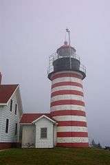 West Quoddy Head Lighthouse
 Center of Lubec as seen from Campobello Island
Climate
Lubec has a humid continental climate with mild summers and cold winters. Generally speaking, it's cold for its coastline position at 44 degrees latitude, but milder in winter than nearby Machias due to moderate warming by the adjacent waters of the Atlantic.
| Climate data for Lubec, Maine | |||||||||||||
|---|---|---|---|---|---|---|---|---|---|---|---|---|---|
| Month | Jan | Feb | Mar | Apr | May | Jun | Jul | Aug | Sep | Oct | Nov | Dec | Year |
| Record high °F (°C) | 61 (16) |
65 (18) |
79 (26) |
84 (29) |
93 (34) |
96 (36) |
98 (37) |
95 (35) |
94 (34) |
84 (29) |
71 (22) |
60 (16) |
98 (37) |
| Average high °F (°C) | 30 (−1) |
32 (0) |
39 (4) |
50 (10) |
60 (16) |
69 (21) |
74 (23) |
74 (23) |
67 (19) |
56 (13) |
46 (8) |
36 (2) |
53 (12) |
| Daily mean °F (°C) | 22 (−6) |
25 (−4) |
32 (0) |
42 (6) |
51 (11) |
59 (15) |
64 (18) |
64 (18) |
58 (14) |
48 (9) |
40 (4) |
29 (−2) |
45 (7) |
| Average low °F (°C) | 14 (−10) |
17 (−8) |
24 (−4) |
34 (1) |
41 (5) |
48 (9) |
54 (12) |
54 (12) |
49 (9) |
40 (4) |
33 (1) |
21 (−6) |
36 (2) |
| Record low °F (°C) | −27 (−33) |
−23 (−31) |
−13 (−25) |
1 (−17) |
24 (−4) |
31 (−1) |
36 (2) |
33 (1) |
23 (−5) |
15 (−9) |
3 (−16) |
−23 (−31) |
−27 (−33) |
| Average precipitation inches (mm) | 3.83 (97) |
3.24 (82) |
4.07 (103) |
3.67 (93) |
3.77 (96) |
3.66 (93) |
2.98 (76) |
3.10 (79) |
4.11 (104) |
4.37 (111) |
4.87 (124) |
4.27 (108) |
45.94 (1,167) |
| Source: The Weather Channel (Historical Monthly Averages) [11] | |||||||||||||
Demographics
| Historical population | |||
|---|---|---|---|
| Census | Pop. | %± | |
| 1820 | 1,430 | — | |
| 1830 | 1,535 | 7.3% | |
| 1840 | 2,307 | 50.3% | |
| 1850 | 2,814 | 22.0% | |
| 1860 | 2,555 | −9.2% | |
| 1870 | 2,136 | −16.4% | |
| 1880 | 2,109 | −1.3% | |
| 1890 | 2,769 | 31.3% | |
| 1900 | 3,005 | 8.5% | |
| 1910 | 3,363 | 11.9% | |
| 1920 | 3,371 | 0.2% | |
| 1930 | 2,994 | −11.2% | |
| 1940 | 3,108 | 3.8% | |
| 1950 | 2,973 | −4.3% | |
| 1960 | 2,684 | −9.7% | |
| 1970 | 1,949 | −27.4% | |
| 1980 | 2,045 | 4.9% | |
| 1990 | 1,853 | −9.4% | |
| 2000 | 1,652 | −10.8% | |
| 2010 | 1,359 | −17.7% | |
| Est. 2014 | 1,304 | [12] | −4.0% |
| U.S. Decennial Census[13] | |||
As of 2000 the median income for a household in the town was $20,565, and the median income for a family was $26,098. Males had a median income of $25,170 versus $19,375 for females. The per capita income for the town was $13,081. About 20.3% of families and 28.8% of the population were below the poverty line, including 49.6% of those under age 18 and 20.6% of those age 65 or over.
2010 census
As of the census[2] of 2010, there were 1,359 people, 682 households, and 356 families residing in the town. The population density was 40.9 inhabitants per square mile (15.8/km2). There were 1,147 housing units at an average density of 34.5 per square mile (13.3/km2). The racial makeup of the town saw 97.7% White, 0.1% African American, 0.2% Native American, 0.3% Asian, 0.3% from other races, and 1.4% from two or more races. Hispanic or Latino of any race were 1.0% of the population.
There were 682 households of which 16.9% had children under the age of 18 living with them, 39.4% were married couples living together, 8.7% had a female householder with no husband present, 4.1% had a male householder with no wife present, and 47.8% were non-families. Of all households 41.9% were made up of individuals and 20.9% had someone living alone who was 65 years of age or older. The average household size was 1.94 and the average family size was 2.58.
The median age in the town was 54 years. 14.1% of residents were under the age of 18; 4.3% were between the ages of 18 and 24; 16.4% were from 25 to 44; 36.9% were from 45 to 64; and 28.3% were 65 years of age or older. The gender makeup of the town was 48.4% male and 51.6% female.
Education
Lubec Consolidated School belongs to Maine School Administrative District #19. James Underwood is the Superintendent of Schools.[14]
Notable people
- Myron Avery, lawyer, explorer
- James Henry Carleton, brevet major general
- Albert Brewer Guptill, author and photographer.[15]
- Sumner Pike, member of the US Securities and Exchange Commission, member of the Atomic Energy Commission
- Hopley Yeaton, ship captain, considered the "Father of the US Coast Guard"
- Hazel Marion Eaton, daredevil, shallow diver, long distance swimmer, hoop roller, motordome thrill racer - one of the "mile a minute girls". Close friend of Beatrice Houdini.
Gallery
 West Quoddy Head Lighthouse at Sunset
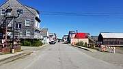 Water Street, Lubec, Maine
 Lubec Brewing Company
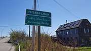 US-Canada Border in Lubec, Maine
 Welcome to Lubec Sign
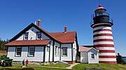 West Quoddy Head Lighthouse
See also
References
- "US Gazetteer files 2010". United States Census Bureau. Retrieved 2012-12-16.
- "U.S. Census website". United States Census Bureau. Retrieved 2012-12-16.
- "Population Estimates". United States Census Bureau. Archived from the original on 2013-06-11. Retrieved 2013-07-06.
- "Profile of General Population and Housing Characteristics: 2010 Demographic Profile Data (DP-1): Lubec town, Washington County, Maine". United States Census Bureau. Retrieved July 20, 2012.
- "The closest point in the United States to Africa". www.acscdg.com. Archived from the original on 2015-09-18. Retrieved 2015-09-08.
- Coolidge, Austin J.; John B. Mansfield (1859). A History and Description of New England. Boston, Massachusetts: A.J. Coolidge. p. 201.
coolidge mansfield history description new england 1859.
- Varney, George J. (1886). "Gazetteer of the state of Maine. Lubec". Boston: Russell. Cite journal requires
|journal=(help) - Klondike: Lubec's Gold from Sea Water Hoax
- "US Board on Geographic Names". United States Geological Survey. 2007-10-25. Retrieved 2008-01-31.
- "Chapter 1: Eastern Maine". United Divide: A Linear Portrait of the USA/Canada Border. The Center for Land Use Interpretation. Winter 2015.
- "Climate Statistics for Lubec, Maine". Retrieved February 12, 2012.
- "Annual Estimates of the Resident Population for Incorporated Places: April 1, 2010 to July 1, 2014". Archived from the original on May 23, 2015. Retrieved June 4, 2015.
- "Census of Population and Housing". Census.gov. Retrieved June 4, 2015.
- "Maine School Administrative District #19". Maine School Administrative District #19. Retrieved 2012-07-06.
- "Harvard University. Class of 1878". 1908. Retrieved 12 December 2018.
Further reading
- Joshua M. Smith, Borderland Smuggling: Patriots, Loyalists and Illicit Trade in the Northeast, 1783–1820 (Gainesville, University Press of Florida, 2006)
External links
| Wikivoyage has a travel guide for Lubec. |
- Town of Lubec official website
- Lubec Memorial Library
- West Quoddy Head Lighthouse
- Quoddy Head State Park
- Visit Lubec Maine
- Bay of Fundy International Marathon - held in Lubec, Maine and Campobello Island, New Brunswick
Municipalities and communities of Washington County, Maine, United States | ||
|---|---|---|
| Cities |  Washington County map | |
| Towns |
| |
| Plantations | ||
| Unorganized territories | ||
| CDPs | ||
| Other villages | ||
| Indian reservations | ||
| Authority control |
|
|---|