Cameron Toll
Cameron Toll is a suburb located to the south of Edinburgh, Scotland. Originally it was the site of a toll house built in the early 19th century, which was located on a stretch of road between Edinburgh and Dalkeith. The meaning of the name Cameron is suggested to be 'crooked hill', derived from the Scots Gaelic 'cam', crooked, and Old Gaelic 'brun' meaning hill, believed to refer to Arthur’s Seat clearly visible nearby; the original name may have been Pictish.[1]
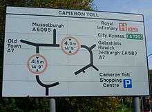
The area is now dominated by a large roundabout, which is crossed by a railway line.
Cameron Toll is 2 miles from Edinburgh city centre, 2 miles from the Edinburgh City Bypass and is served by many bus services to and from Edinburgh and Midlothian. It is close to The Grange and Newington and the area called The Inch.
Cameron Toll Shopping Centre
The area is the location of Cameron Toll Shopping Centre (known as Savacentre to locals), Edinburgh’s first ‘out of town’ shopping centre, which opened in 1984 at a cost of £33 million. Built in the former grounds of Inch House between the A7 and A701 roads, the centre occupies a 26-acre site.[2]
Cameron Toll had the first ever bank that opened on Sundays in the UK. It also led the way by having lighting which was controlled by a computer system.
The main shops in Cameron Toll are Sainsbury's and Aldi.[2]
Flooding
The shopping centre was built on the low-lying flood plain of the Braid Burn, which is culverted for much of its course through this neighbourhood. Flooding of the area took place soon after the centre's opening and has recurred several times: in August 2008 local residents had to deal with metre-high floods. Between 2004 and 2010 the City of Edinburgh Council implemented flood prevention measures along much of the course of the Braid Burn. However the shopping centre and its immediate environs remain a target area for which the Scottish Environment Protection Agency (SEPA) undertakes to provide flood warnings as necessary.[3]
Liberton Bank House and Conan Doyle Medical Centre
Liberton Bank House, now a category C listed building, lies on the south-west corner of the site.[4] Built around 1780, it was occupied by the educational and social reformer Mary Burton from 1844.[4] She was friendly with the Conan Doyle family and the young Arthur Conan Doyle, stayed there with her so that he could be close to his school Newington Academy at 6 Arniston Place, which he attended from 1866-68.[5] It also allowed him some refuge from the influence of his alcoholic father.[6] Since a major restoration by Groves-Raines Architects in 2007 this has housed Dunedin School, which provides secondary education for pupils for whom mainstream education is not appropriate.[7] The Conan Doyle Medical Centre next to it was designed by Richard Murphy Architects and opened in 2007.[8]
See also
- St Margaret's School, which was formerly based nearby.
References
- Ross, D.(2001) Scottish Place- names, Birlinn, Edinburgh ISBN 1-84158-173-9, p.43
- "Cameron Toll Shopping Centre from The Gazetteer for Scotland". www.scottish-places.info. Retrieved 28 May 2019.
- http://floodline.sepa.org.uk/floodupdates/info/group-id/4922
- "Liberton Bank House (LB47155)". portal.historicenvironment.scot. Retrieved 28 May 2019.
- sunkenroads (3 April 2016). "Liberton Bank House: Conan Doyle's childhood refuge". sunken roads. Retrieved 28 May 2019.
- "Liberton Bank House - South Edinburgh Net :: South Edinburgh's Community Network". www.southedinburgh.net. Retrieved 28 May 2019.
- "Dunedin School | Edinburgh". Retrieved 28 May 2019.
- "Richard Murphy Architects: Conan Doyle Medical Centre At Nether Liberton Lane, Edinburgh". www.richardmurphyarchitects.com. Retrieved 28 May 2019.