Moredun
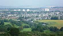
Moredun is a district in the south-east of Edinburgh, the capital of Scotland. It is east of Liberton, while Craigour is situated just to its north.[1][2]

Originally a mansion called Gut-tres or Goodtrees, the estate was renamed Moredun House in 1769 by David Stuart Moncrieff in recognition of a hill on his Perthshire estate.[3] The house was acquired in 1923 to convert into a convalescent home for ex-servicemen. It was instead found unsuitable and demolished. The facility was instead created in the form of the Murray Homes for the Scottish Veterans Association in 1929. Part of the estate was also sold in 1924 to create the Moredun Research Institute.[4]
In the 1960s six tower blocks were built in the area, whilst all six remain a large project was undertaken to refurbish these tower blocks, to coincide with the building of the Edinburgh Royal Infirmary. Two of these tower blocks, Moncreiffe House and Forteviot House, are within the geographical boundary of Moredun, while the other four are technically in neighbouring Craigour.
Moredun contains two clusters of shops on Moredun Park Road as well as a library and a primary school. It has transport links on a par with other similar areas of the city, with the Lothian Buses service 8 and Edinburgh City Council chartered Lothian and First East Lothian 18 passing through the area, with the 3, 7 and 29 services running nearby.
Sources
- "Google Maps".
- "OpenStreetMap".
- "Archived copy". Archived from the original on 26 October 2016. Retrieved 23 November 2011.CS1 maint: archived copy as title (link)
- Tracing Your Edinburgh Ancestors, Alan Stewart