Cévennes
The Cévennes (/seɪˈvɛn/ say-VEN,[1][2][3] French: [sevɛn] (![]()
| Cévennes | |
|---|---|
| Occitan: Cevenas | |
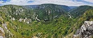 The Gorges du Tarn | |
| Highest point | |
| Peak | Mont Lozère |
| Elevation | 1,702 m (5,584 ft) |
| Coordinates | 44°25′34″N 03°44′21″E |
| Naming | |
| Pronunciation | English: /seɪˈvɛn/ say-VEN French: [sevɛn] ( |
| Geography | |
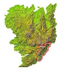 Location in the Massif Central
| |
| Country | France |
| Départements | Gard, Lozère, Ardèche and Haute-Loire |
| Parent range | Massif Central |
The name Cévennes comes from the Gaulish Cebenna.[6] As of 1999, there were 165,707 inhabitants in the region, with 20,847 living inside the UNESCO protected zone.[7]:108 Inhabitants of the region are known as Cévenols, from the adjective Cévenol (fem. Cévenole)[8]
Too poor to host cities, too rich to be abandoned, the landscape of Causses and Cévennes are the result of the modification of the natural environment by agro-pastoral systems over a millennium. The Causses and Cévennes demonstrate almost every type of pastoral organisation to be found around the Mediterranean
— UNESCO World Heritage Committee, "Cultural Properties - The Causses and the Cévennes, Mediterranean agro-pastoral Cultural Landscape (France)", Decision : 35 COM 8B.39 (2011)[9]
The mountain range also gives its name to a meteorological effect when cold air from the Atlantic coast meets warm air of southern winds from the Mediterranean and causes heavy autumnal downpours, often leading to floods. These are called épisodes cévenols.
Defining the Cévennes
Etymology
The origin of the name Cévennes is Celtic,[10] coming from the Gaulish Cebenna, which was Latinized by Julius Caesar to Cevenna.[11] The Cévennes are named Cemmenon (Κέμμενων) in Strabo's Geographica. The word in Gaulish probably meant ridgeline[12] and is related to the Breton word kein meaning back.[6] The -vennes part of the name is likely related to the Gaelic word beinn meaning mountain or hill.[10]
There are several popular false etymologies, one of which is that the name is derived for the words seven veins (sept veines in French) which is supposed to be a reference to the seven rivers (veins) flowing through the region. Historical references to the name that predate the French Language itself, preclude this possibility.[10] Another false etymology suggests that the name comes from the Occitan word ceba (also written cebo) which means "onion", which is supposed to reference the layered structure of slate which makes up the mountains. But this is not possible as the Occitan ceba derives from Latin cepa which does not phonetically fit the references to the region in Latin and Greek Literature. Additionally, the suffix -enna, originally Celtic, was brought over into Latin, and was never used for words of Latin origin.[13][14]
Geography
Extent
In the larger sense, the Cévennes include nine départements : le Tarn, l'Aude, l'Hérault, l'Aveyron, le Gard, la Lozère, l'Ardèche, le Rhône et la Loire. More strictly the Cevennes encompasses the Lozère and the Gard. The Parc national des Cévennes is almost entirely within Lozère.[15]
The principal towns and villages of the Cévennes are Alès, Le Vigan, Sumène, Valleraugue, Ganges, Saint-Hippolyte-du-Fort, Sauve, Lasalle, Saint-André-de-Valborgne, Saint-Jean-du-Gard, Anduze, Florac, Saint-Germain-de-Calberte, le Pont-de-Montvert, Villefort, Génolhac, Bessèges, Saint-Ambroix, Gagnières, Les Vans, Mende.
Description

The Cévennes mountains run from southwest (Cause Noire) to northeast (Monts du Vivarais), with the highest point being the Mont Lozère (1702m). The Mont Aigoual (1567m) is on the border of two departments. The Loire and Allier flowing towards the Atlantic Ocean, as well as the Ardèche and tributary Chassezac, Cèze, the different rivers Gardons to the Rhône, Vidourle, Hérault and Dourbie that flow to the Mediterranean Sea, have their headwaters in the Cévennes. Cévennes National Park was created in the region in 1970 and the Parc Naturel Régional des Monts d'Ardèche also preserves some of the natural areas. Two canyons are near the region: the Gorges de la Jonte (the Jonte gorge) and the Gorges du Tarn (the Tarn gorge). This is a socio-economic marginal region, while bio-geographically, there is altitudinal stratification and a gradient between the mountainous centre and the mediterranean littoral ecologies.[15]
Geology
The Cévennes form the south eastern fragment of the Massif Central, separated from the related Montagnes Noires by the limestone Causses. The basement rocks of Granites and Schistes were uplifted by the Variscan Orogeny forming a discontinuity, with the subsequent erosion infilling the lower voids for much of Permian and Triassic period (280 - 195 Ma), while changing sea levels added a thick limestone covering, with only the tops of the Cévennes protruding as islands in the Jurassic sea. This in turn was eroded, The Cévennes forms the watershed between the Atlantic and Mediterranean. In late Cretaceous and early Tertiary times further mountain building occurred. The Alpine orogeny lifted and deformed the Alps and the Pyrenees though the Massif Central acted as a rigid block, and the cover rocks remained mostly horizontal. Some have been folded through later faulting at the time of the opening of the western Mediterranean in Tertiary times. The principal rivers of the region have cut deeply into the limestone forming deep gorges: Gorges du Tarn, Gorges de la Jonte, Lot, Gorges de l'Ardèche, Cèze etc.[16]
Population and history
Prehistory
"Before silk, before Calvin, a prehistory"[17]
Transhumance is most likely the beginning of human activity in the Cevennes[18]:23 but little trace has been found of humans from the Paleolithic era except in the southern portion around Ganges and Saint-Hippolyte-du-Fort which contains a large quantity of caves rich with archeological evidence such as "La Roque Aynier" (Ganges), and "Baume Dolente"(Vebron) which suggest the presence of Magdalenian peoples (17,000-12,000 BCE).[18]:25
By the Neolithic epoch, which lasted from about 12,000 BCE to around 2,300 BCE in France (Bronze Age (FR)), transhumance and hunting were prevalent throughout the entire Cevennes with developments such as pottery moving from south to north in the region. Sheep were common in Mediterranean France before 7000 BCE[18]:23 and numerous prehistoric pots and tools have been recovered dating from as early as 4000 BCE.[19] Around this time many Megalithic constructions such as stone circles, dolmen, and menhirs appeared in the area, with the second largest megalithic site in Europe, the alignements des Bondons,[20] being created around 3,000-2,500 BCE,[21] and important sites such as the stone circles around Blandas in the south appearing between 3,500-2,500 BCE.[22][23]
Ancient
The Celts arrived in the area sometime in the Iron Age between 800-400 BCE, and most of what is known about their presence in the area is from Latin historians.[24] In the 3rd century BCE, the Averne Confederation was formed of several tribes who used the Cevennes as a defensive feature to prevent the Romans from taking their territories.[25] By the time the Romans successfully conquered the area in 121 BC, several tribes of celtic Gauls were living around the Cevennes: the Ruteni in the west, the Gabali in the north, the Volcae Arecomici in the south, the Helvii in the southeast et les Vellavi in the northeast.[26] The Volcae Arecomici voluntarily surrendered their territory to the Romans,[27] and the Arverni gave up much territory in a treaty that nevertheless preserve their independence.
Under Roman control, Le Vigan was part of the Roman "Provincia," (hence Provence) called Gallia Narbonensis. Julius Caesar crossed the Cevennes mountains in the winter of 52 BCE, having his soldiers clear paths in up to six feet of snow, to attack the Averne Confederation.[28]:231
The Visigoths took control of the western half of Gallia Narbonensis in 462 CE, a part known as Septimania which included Le Vigan, and they retained control despite attempts in 586 and 589 BCE when the Frankish, Merovingian King Guntram attempted to conquer the area from the north.
Middle Ages
In 587 the region came under Catholic rule with the conversion of the Visigoth king Reccared I. In 719, the Moor Al-Samh conquered Septimania as part of the Umayyad invasion of Gaul and the Franks struggled to take it back over the next several decades. By 780, Charlemagne had conquered the entire territory.
The “Desert” period and the Camisards War
French Protestants, the Huguenots, were established in the Cevennes by the beginning of the 16th century but were often persecuted, and lacked the freedom to worship openly, and kept away from cities. They worshiped in deserted wilderness areas: forests, caves, and gullies.[29] The Edict of Nantes in 1598 gave some relief and freedom of worship to Protestants but also concentrated the power of the Catholic Church in France[30]
The Edict of Fontainebleau, on October 1685, revoked the Edict of Nantes, and forbade Protestant worship services. It called for the destruction of temples, exiling pastors, and forced Catholic instruction on the children. The borders were closed due in response to the exodus of protestants from the area and the resulting economic losses. The protestants who stayed resisted and, known as Camisards in the Cévennes, they took up arms to fight for their religious freedom. As many as 3,000 Protestants fought against 30,000 royal troops from 1702 till 1704.[31] Sporadic fighting continued until 1715[32] The Edict of Versailles in 1787,[33] and the French Revolution and the Declaration of the Rights of Man in 1789,[34] finally brought a political solution to the struggles and gave non-Catholics the right to practice their religion openly.
Modern
In the 21st century, the region still has a large community of French Protestants. They identify as Huguenots, descendants of peoples who have inhabited the mountains since before the 16th century. During the reign of Louis XIV, much of the Huguenot population fled France, particularly following the Revocation of the Edict of Nantes in 1685. The Protestant community in the Cévennes largely remained in place, protected from attack by the hilly terrain. This area became a refuge from persecution for other Huguenots during the time.
In 1702, this Huguenot population, dubbed the Camisards, rose up against the monarchy to protect their religious freedom.[35] The two sides agreed to peace in 1715, which enabled the local Protestant Huguenot population to continue living in the Cévennes. Their descendants have continued to live there to the present day.
During World War 2, a network of families in the Cévennes sheltered a number of Jews from capture by the Nazis. These efforts, organized by local Protestant pastors, ultimately protected hundreds from capture and likely death.[36]
Popular Culture
- d'Indy, a composer of Ardèche origin, wrote the Symphonie Cévenole (known in English as his Symphony on a French Mountain Air).
- Robert Louis Stevenson, a Scottish writer, visited the Cevennes in 1878 and wrote Travels with a Donkey in the Cévennes (1879) about his experiences
Transport
3-hour TGV from Paris, 1h30 flight from London (Luton) to Nîmes (Garons), the closest international airport and 3h30 drive from Barcelona.
By car
- A75 Montpellier – Clermont-Ferrand – Paris
- A9 (la Languedocienne) Barcelona (Espagne) – Montpellier
Tourism
- The Corniche des Cévennes (the D 907) is a spectacular road between St-Jean-Gard and Florac. It was constructed at the beginning of the 18th century to enable the movement of Louis XIV's troops during his conflict with the Camisards.
References
- "Cévennes". The American Heritage Dictionary of the English Language (5th ed.). Boston: Houghton Mifflin Harcourt. Retrieved 16 May 2019.
- "Cévennes". Collins English Dictionary. HarperCollins. Retrieved 16 May 2019.
- "Cévennes" (US) and "Cévennes". Oxford Dictionaries UK Dictionary. Oxford University Press. Retrieved 16 May 2019.
- "Cevennes | United Nations Educational, Scientific and Cultural Organization".
- "Cevennes National Park, France -- National Geographic". 8 April 2011.
- Le Dû, Jean; Brun-Trigaud, Guylaine (17 September 2013). "Les Aires Dialectales Gallo-Romanes A La Lumiere du Celtique". In Xosé Álvarez, Ernestina Carrilho (ed.). Current Approaches to Limits and Areas in Dialectology (in French). Catarina Magro. Newcastle upon Tyne: Cambridge Scholars Publishing. pp. 32–. ISBN 978-1-4438-5285-2. Retrieved 29 March 2019.
- https://whc.unesco.org/uploads/nominations/1153rev.pdf
- https://www.theguardian.com/world/2010/apr/24/cevennes-mountains-south-of-france
- https://whc.unesco.org/en/decisions/4310
- Kenneth White; Daniel Faure; Michelle Sabatier (1998). Cévennes. Renaissance Du Livre. pp. 11–. ISBN 978-2-8046-0217-8.
- "Culture et Patrimoine".
- "Cévennes Gardoises".
- "Atlas du parc national des Cévennes - Relief, pentes, expositions". atlas.parcsnationaux.org. 20 November 2016. Archived from the original on 29 June 2009. Retrieved 30 March 2019.
- http://archive.wikiwix.com/cache/index2.php?url=http%3A%2F%2Fatlas.parcsnationaux.org%2Fcevennes%2Fpage.asp%3Fpage%3D16
- S. Souchay, Du paysage à sa dénomination, une contrée cévenole, maîtrise de géographie Toulouse Mirail, 2005.
- Suthren., Roger (2003). "Rocks and Scenery of the Mont Lozère Region, France". Oxford Brookes University's Ecology field course to the Cévennes. Oxford Brookes University. Retrieved 10 August 2016.CS1 maint: ref=harv (link)
- Joutard, Philippe (1979). Les Cévennes. De la montagne à l'homme. Toulouse: Privat. ISBN 9782708980105.
- Cabanel, Patrick (August 24, 2016). Histoire des Cévennes (in French). Presses Universitaires de France. p. 128. ISBN 978-2130749363.
- "Archived copy". Archived from the original on 2009-06-17. Retrieved 2006-06-14.CS1 maint: archived copy as title (link)
- "Cham des Bondons".
- "Cham des Bondons - les Bondons".
- "Les environs de Ganges (Cévennes)".
- "The Prehistory of the Causses, the Cevennes & Gorges of the Tarn region. | History".
- http://www.reveeveille.net/un_ecrit.aspx?idecrit=424
- http://www.reveeveille.net/un_ecrit.aspx?idecrit=425
- https://www.causses-cevennes.com/histoire-des-causses-cevennes
- Gaius Julius Caesar (12 December 2012). The Gallic Wars. Winged Hussar Publishing. pp. 392–. ISBN 978-1-62018-073-0.
- Caesar, Julius (1904). Caesar's Commentaries on the Gallic War. Lee & Shepard.
- http://www.museedudesert.com/article5759.html
- https://www.britannica.com/event/Edict-of-Nantes
- http://www.museedudesert.com/article5765.html
- Philippe Joutard, Les Camisards, Gallimard 1976, rédité en coll. Folio Histoire en 1994, pp.217-219
- Encyclopedia of the Age of Political Ideals: 'Edict of Versailles (1787)'. 29 January 2012. Archived from the original on 14 July 2012. Retrieved 26 March 2019.
- https://templedurouve-english.asso-web.com/23+the-camisard-war.html
- The first Camisards and freedom of conscience
- Culp, Kristine (2010). Vulnerability and glory : a theological account. Louisville, Ky.: Westminster Knox Press. pp. 128–130.
External links
| Wikimedia Commons has media related to Cévennes. |
| Wikivoyage has a travel guide for Cevennes. |
| Wikisource has original text related to this article: |