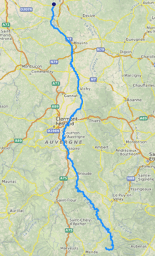
Allier (river)
The Allier (UK: /ˈælieɪ/ AL-ee-ay,[1] US: /ælˈjeɪ, ɑːlˈjeɪ/ a(h)l-YAY,[2][3] French: [alje] (![]()
| Allier | |
|---|---|
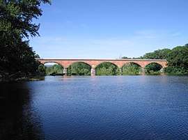 Bridge over the Allier | |
 | |
| Native name | Alèir (Occitan) |
| Location | |
| Country | France |
| Physical characteristics | |
| Source | |
| ⁃ location | Massif Central |
| ⁃ elevation | 1,503 m (4,931 ft) |
| Mouth | |
⁃ location | Loire |
⁃ coordinates | 46°57′34″N 3°4′44″E |
| Length | 421 km (262 mi) |
| Basin size | 14,350 km2 (5,540 sq mi) |
| Discharge | |
| ⁃ average | 140 m3/s (4,900 cu ft/s) |
| Basin features | |
| Progression | Loire→ Atlantic Ocean |
Departments and towns
The Allier flows through the following departments, and along the following towns:
- Allier: Moulins, Varennes-sur-Allier, Vichy, Saint-Yorre
- Ardèche - the river runs along the border between this department and Lozère
- Cher: Mornay-sur-Allier, Château-sur-Allier
- Haute-Loire: Brioude, Langeac, Monistrol-d'Allier
- Lozère: Langogne, La Bastide-Puylaurent
- Nièvre
- Puy-de-Dôme: Brassac-les-Mines, Auzat-sur-Allier, Issoire, Cournon-d'Auvergne, Pont-du-Château, Cournon-d'Auvergne
Tributaries
The main tributaries of the Allier are:
Ecology
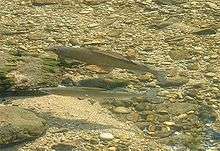
The Allier is one of the rare places in southern Europe where the freshwater grayling (Thymallus thymallus), known in French as ombre des rivières, occurs in a natural habitat.[5]
Grayling like to live in shoals and are sensitive to pollution. In the Allier these fish are more abundant in the stretch between Langogne and Brioude. They are economically important, being appreciated for food and fished for sport.
Gallery
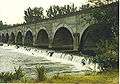 The bridge Le Guétin.
References
| Wikimedia Commons has media related to Allier River. |
| Wikisource has the text of a 1911 Encyclopædia Britannica article about Allier River. |
- "Allier". Lexico UK Dictionary. Oxford University Press. Retrieved 21 August 2019.
- "Allier". Collins English Dictionary. HarperCollins. Retrieved 21 August 2019.
- "Allier". Merriam-Webster Dictionary. Retrieved 21 August 2019.
- Sandre. "Fiche cours d'eau (K---0080)".
- "The grayling zones of rivers and their tributaries" (PDF). Archived from the original (PDF) on 2009-02-07. Retrieved 2009-01-14.