Montagnes Noires
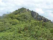
The Montagnes Noires (French: 'the black mountains'), also known as the Montagne Noire (French: 'the black mountain')[1] and in Breton as Menez Du[2] are an east-west oriented range of hills in Brittany centred on the town of Gourin. They culminate in the peak of Roc de Toullaeron (Breton: Roc'h Toull-al-Laeron) which attains a height of either 318m[3] or 326m.[4] Other significant peaks include Ar Menez (304m) and Montagne Noir (307m) (or, in Breton: Menez Du).[5] They are composed from a range of Precambrian, Ordovician, Silurian and Devonian rocks forming a part of the Variscan orogen and include sandstones, quartzites and slates.[6]
- Not to be confused with the Montagne Noire of Languedoc-Rousillon
The hills form a part of the border between the départements of Finistère and Morbihan and just extend into Côtes-du-Nord.
References
- Carte Geologique de la France, 1:1,000,000 scale, 5th edn, Bureau de Recherches Geologiques et Minieres
- "Archived copy". Archived from the original on 2010-03-03. Retrieved 2010-03-10.CS1 maint: archived copy as title (link)
- "Archived copy". Archived from the original on 2014-04-21. Retrieved 2014-04-20.CS1 maint: archived copy as title (link)
- Collins Road Atlas France 1988, based on IGN mapping 1988
- "Archived copy". Archived from the original on 2010-03-02. Retrieved 2010-03-10.CS1 maint: archived copy as title (link)
- Carte Geologique de la France, 1:1,000,000 scale, 5th edn, Bureau de Recherches Geologiques et Minieres
| Wikimedia Commons has media related to Montagnes Noires. |