Burleigh Heads, Queensland
Burleigh Heads is a coastal suburb in the City of Gold Coast in Queensland, Australia.[2]
| Burleigh Heads Gold Coast, Queensland | |||||||||||||||
|---|---|---|---|---|---|---|---|---|---|---|---|---|---|---|---|
 A beach in Burleigh Heads with high rise developments further in the background | |||||||||||||||
| Population | 10,077 (2016 census)[1] | ||||||||||||||
| Postcode(s) | 4220 | ||||||||||||||
| LGA(s) | Gold Coast City | ||||||||||||||
| State electorate(s) | Burleigh | ||||||||||||||
| Federal Division(s) | McPherson | ||||||||||||||
| |||||||||||||||
Geography
The suburb boundary extends as far north as the Miami Headland in Miami, and as far south as Tallebudgera Creek at Palm Beach. To the north is Burleigh Waters, a suburb with a man-made lake, council parks and gardens. In the west of the suburb is the former township of West Burleigh, with shopping and industrial areas.[3][4] The centre of the Burleigh beach neighborhood is James Street, which consists of cafes, delis, hairdressers, retailers, chemists, restaurants and charity stores.
Burleigh beach
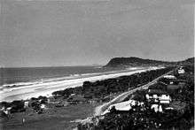
The north-east facing beach is protected by the cape Burleigh Head[5] to the south and offers one of the best swimming, body boarding and surfing beaches on the Gold Coast. A mature stand of Norfolk Island Pines – originally planted by the Justins family and reputably some of the earliest planted at the coast – and more recent plantings together totalling some 450 Norfolk Pines; form a backdrop and are home to native birds.[6][7]
Burleigh Heads' surf break attracts surfers from the Gold Coast and beyond. At the headland of Burleigh, locally known as "The Point", barbecues and cricket matches are held, and spectators can watch the surfers. On Sunday afternoons, local musicians and fire-twirlers often come out to the park beside Burleigh SLSC for a jam and dance session.
History
Indigenous Australians inhabited the area of Burleigh Heads for thousands of years prior to European settlement.[8] The Indigenous tribe were known as the Kombumerri clan, who had named the area 'Jellurgal'.
In 1840, James Warner was commissioned to survey the coastline near Moreton Bay. Warner named the headlands near Tallebudgera Creek, 'Burly Head' because of its massive appearance.[9] Decades later the name was adapted to the more genteel spelling of 'Burleigh Heads' and was declared a town reserve by the Queensland Government in 1871.
On 2 July 1872 at the Lands Office in Beenleigh there was a sale of Crown land in the Town of Burleigh consisting of 65 suburban lots ranging from 1 to 3.5 acres (0.40 to 1.42 ha) and 19 country lots ranging from 5 to 27 acres (2.0 to 10.9 ha) on or near Tallebudgera Creek.[10][11] On 2 April 1873 at the Lands Office in Beenleigh a further 40 suburban lots mostly about 1 acre (0.40 ha) were offered for sale.[12]
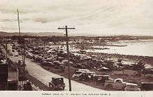
By 1873, the township had been surveyed, a number of the allotments sold and a track created connecting Burleigh Heads to Nerang.[13] References to its magnificent beach were starting to appear and reports in newspapers suggested that Burleigh Heads' natural beauty had the potential to eclipse all other seaside locations in the region.[14][15] However, despite the eventual sale of all the allotments in the township, by 1885, there was only one accommodation house run by Fredrick Fowler and very few, if any, privately owned houses.[16] Further subdivisions and land sales took place in Burleigh during 1914,[17] 1915,[18] 1930,[19] 1929 and[20] 1947.[21]
On 11 November 1879, the Queensland Government created 74 division of local government which saw Burleigh Heads zoned into the Nerang Division. On 9 December 1948, as part of a major reorganisation of local government in South East Queensland an Order in Council replaced ten former local government areas between the City of Brisbane and the New South Wales border with four new local government areas.[22] Despite being a part of the Nerang Shire prior to the reorganisation, Burleigh Heads was claimed by the newly created Town of South Coast, joining fellow coastline suburbs Southport and Coolangatta.
In January 1884, 278 subdivided allotments of the Burleigh Head North estate were auctioned by John Cameron, auctioneer. A map advertising the auction shows the estate to be fronting the Esplanade and close to the Nerang Creek.[23][24]


The northern section appears to have been subdivided by the mid 1950s, but was the site of extensive sand mining in the following decades. The broad beachfront park is a legacy of that activity.
Burleigh township itself is much older and was the site of early development including restaurants and guest houses to support the increasing interest in bathing that took place in the last years of the 19th century and the first of the 20th century. It has been the centre of beach activities and a camping site for many years.[25] The commercial centre of James and Conner Streets was established by the 1930s and began to boom during the postwar period.[26]
The De Luxe Theatre was built by William Fradgley and opened on Wednesday 15 October 1930.[27] It showed silent movies initially with its first "talkie" on Wednesday 9 September 1931, featuring the movies Paradise Island, Hot Curves and a "Mickey the Mouse" cartoon.[28][29] It was also used for Catholic church services prior to the construction of the Infant Saviour Roman Catholic Church. World War II was a boom time for the cinema as there were camps for both Australian and American army personnel in the area. In February 1945 the Thams Brothers (Lorenz and Charles Thams who owned and operated other cinemas on the Gold Coast) leased the De Luxe, purchasing it in 1950. Cyclonic winds damaged the cinema on Friday 19 and Saturday 20 February 1954, and it needed to be rebuilt. The Thams sold the cinema on 29 June 1966. The building gradually became derelict. It was converted in the 1970s into the Old Burleigh Theatre Arcade, with shops, restaurants and offices. In August 2019, the complex and an adjacent building were sold for about $18.5 million, which the short-term intention of continuing its current operations but with a long-term view of redeveloping the site.[30][31]
The Burleigh Library opened in 1993 and had a major refurbishment in 2010.[32]
At the 2011 Census, Burleigh Heads had a population of 9,188.
Heritage listings
Burleigh Heads has a number of heritage-listed sites, including the David Fleay Wildlife Park[33] and the West Burleigh Store,[34] both located on Tallebudgera Creek Road.
Demographics
In the 2011 Census the population of Burleigh Heads is 9,188, 52.2% female and 47.8% male.[35] The median/average age of the Burleigh Heads population is 40 years of age, 3 years above the Australian average.[35] 69.3% of people living in Burleigh Heads were born in Australia. The other top responses for country of birth were New Zealand 6.8%, England 4.6%, Brazil 0.9%, Scotland 0.8%, South Africa 0.6%. 85.2% of people speak English as their first language 0.8% Portuguese, 0.5% Italian, 0.4% German, 0.4% Japanese, 0.3% French.[35]
Geology
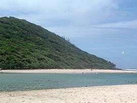
The area of Burleigh Head was formed between 20 and 23 million years ago from molten lava due to numerous eruptions of Mount Warning. Flowing lava reached the shore in the area to form Burleigh headland and Point Danger.[36] Geological processes that shaped the region resulted in a variety of different rock types, influencing the landscape, vegetation types and the animals they sustained. Queensland University geologists and students began coming to the area to collect specimens in the 1920s.[37]
Ecology
Burleigh Headland is part of a wildlife corridor connecting coastal forests south to the Queensland New South Wales border ranges.[38] Burleigh Ridge Park Reserve has a diverse habitat due to its geology. Conservation of the area has preserved many local plants that indigenous people would have used over 200 years ago. There are Eucalypt forest species favoured by Koalas. Other native wildlife include flying foxes, gliders and over 60 bird species.[39]
Transport
Gold Coast Highway travels along the eastern side of the suburb passing through the heart of suburb. Gold Coast highway connects Burleigh Heads with all the coastal suburbs on the Gold Coast. West Burleigh Road (State Route 80) eventually becomes Reedy Creek Road after an intersection in front of Stocklands Burleigh Heads, connects the heart of the suburb with the Pacific Motorway and Varsity Lakes railway station.
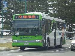
Burleigh Heads is serviced by Translink services, a subsidiary of the Department of Transport and Main Roads, who operate an integrated ticketing system throughout South East Queensland. Burleigh Heads Bus stop is the main bus stop in the suburb, located on the Gold Coast Highway. A bus service connects Burleigh Heads with the Gold Coast Airport, Tweed Heads, Robina and Broadbeach.
Consultation is in process to extend the existing G:link tram to Burleigh Beach from Broadbeach commencing in 2020.[40]
Schools
There are several schools in the Burleigh area including two state primary schools, Caningeraba State School located in Burleigh Waters and Burleigh Heads State School. Burleigh Heads State School was established in 1917 as the Burleigh School, with its name changed to Burleigh Heads State School in 1927. It moved to its present site on the Lower Gold Coast Highway, Burleigh Heads, in 1935.
There are no state high schools in Burleigh Heads with students attending Miami State High School or Elanora State High School.
The largest school in the area is Marymount College, a Catholic day school educating both boys and girls from Prep to Year 12. The school has over 2,000 students combined across the two campuses, Primary and Secondary, which are located on the corner of West Burleigh Rd and Bermuda St, Burleigh Waters.
Amenities
The Gold Coast City Council operate a public library at Fradgley Hall in Park Avenue.[41]
Events
Burleigh Heads State School is home to The Village Markets.[42] A bi-monthly event that promotes local emerging designers and artists.
Sport and recreation
Surfing
- Stubbies Surf Classic Burleigh Heads 1977 -1988
- The Quiksilver Pro is often contested at Burleigh Heads when the surf is not contestable at Kirra or Snapper Rocks.
- The Breaka Burleigh Pro Burleigh Boardriders Single Fin Classic and many other amateur and junior events are also contested each year.
- Professional/World tour Surfers Peter Harris and Jay Thompson
Others
- Australian rules club – Bombers Aussie Rules Footy Club
- Bowls club – Burleigh Heads Bowls Club
- Cricket club – Burleigh Bullsharks
- Golf club – Burleigh Golf Club
- Rugby league club – Burleigh Bears
- Soccer club – Burleigh Heads Soccer Club
- Surf Life Saving – Burleigh Heads Mowbray Park Surf Life Saving Club
- Tennis club – Burleigh Heads Tennis Club
- Hockey Club - Hockey Burleigh
See also
References
- Australian Bureau of Statistics (27 June 2017). "Burleigh Heads (State Suburb)". 2016 Census QuickStats. Retrieved 6 February 2018.

- "Burleigh Heads - suburb (entry 46034)". Queensland Place Names. Queensland Government. Retrieved 26 June 2017.
- "West Burleigh - neighbourhood in Gold Coast City (entry 37032)". Queensland Place Names. Queensland Government. Retrieved 6 August 2019.
- "Queensland Globe". State of Queensland. Retrieved 6 August 2019.
- "Burleigh Head - cape in Gold Coast City (entry 5363)". Queensland Place Names. Queensland Government. Retrieved 6 August 2019.
- "BURLEIGH HEADS". The Courier-Mail. Brisbane. 22 September 1936. p. 10. Retrieved 17 January 2016 – via National Library of Australia.
- "BURLEIGH HEADS". South Coast Bulletin. Southport, Qld. 5 April 1940. p. 10. Retrieved 17 January 2016 – via National Library of Australia.
- Candice Marshall and Peter Scott (20 December 2012). "Burleigh Heads: the indigenous side". abc.net.au. Archived from the original on 30 October 2013. Retrieved 20 August 2013.
- "Burleigh history, City of Gold Coast". Archived from the original on 12 September 2015. Retrieved 9 November 2015.
- "CROWN LANDS FOR SALE". The Brisbane Courier. Queensland, Australia. 1 June 1872. p. 6. Retrieved 26 May 2020 – via Trove.
- "Plan of sections nos. 1 to 7, Town of Burleigh, Parish of Mudgeeraba, County of Ward". State Library of Queensland (Real estate map). 1872. Retrieved 26 May 2020.
- "Classified Advertising". The Brisbane Courier. Queensland, Australia. 3 March 1873. p. 4. Retrieved 26 May 2020 – via Trove.
- "Country News, by Mail". The Queenslander. VIII (398). 20 September 1873. p. 10. Retrieved 28 May 2016 – via National Library of Australia.
- "THE NERANG RIVER AND THE SOUTHERN BORDER". The Brisbane Courier. Queensland, Australia. 19 September 1873. p. 3. Retrieved 26 May 2020 – via Trove.
- "Out for a Holiday". The Queenslander. IX (26). 1 August 1874. p. 7. Retrieved 28 May 2016 – via National Library of Australia.
- "A Visit to Burleigh Head". Logan Witness. VIII (377). Queensland. 11 July 1885. p. 3. Retrieved 28 May 2016 – via National Library of Australia.
- "Sale of Burleigh Land". The Brisbane Courier (17, 466). 6 January 1914. p. 7. Retrieved 28 May 2016 – via National Library of Australia.
- "BURLEIGH TOWNSHIP ESTATE". The Telegraph (13221) (SECOND ed.). Brisbane. 7 April 1915. p. 7. Retrieved 28 May 2016 – via National Library of Australia.
- "BURLEIGH LAND SALE". South Coast Bulletin. 2 (106). Queensland. 19 December 1930. p. 6. Retrieved 28 May 2016 – via National Library of Australia.
- "Burleigh Heads Centre". South Coast Bulletin. 1 (52). Queensland. 27 December 1929. p. 6. Retrieved 28 May 2016 – via National Library of Australia.
- "SALE OF BURLEIGH LAND AS PERPETUAL LEASES". Queensland Times (18, 770) (DAILY ed.). 31 January 1947. p. 5. Retrieved 28 May 2016 – via National Library of Australia.
- "Gold Coast City Council". First National Real Estate. Retrieved 20 January 2020.
- "Burleigh Head North". State Library of Queensland. 19 January 1884. hdl:10462/deriv/451598. Cite journal requires
|journal=(help) - "Advertising". The Telegraph (3, 504). Queensland, Australia. 8 January 1884. p. 4. Retrieved 24 September 2019 – via National Library of Australia.
- "Camping at Burleigh Heads". The Brisbane Courier. 1 January 1912. p. 6. Retrieved 17 January 2016 – via National Library of Australia.
- "Burleigh Heads Heritage & Character Study" (PDF). Gold Coast City Council. November 2010. p. 22. Archived (PDF) from the original on 5 March 2016. Retrieved 9 November 2015.
- "OFFICIAL OPENING". South Coast Bulletin. 2 (97). Queensland, Australia. 17 October 1930. p. 3. Retrieved 6 August 2019 – via National Library of Australia.
- "BURLEIGH TALKIES". South Coast Bulletin. 3 (145). Queensland, Australia. 4 September 1931. p. 1. Retrieved 6 August 2019 – via National Library of Australia.
- "BURLEIGH TALKIE PICTURES". South Coast Bulletin. 3 (146). Queensland, Australia. 11 September 1931. p. 6. Retrieved 6 August 2019 – via National Library of Australia.
- Herde, Chris (6 August 2019). "Interstate developer snaps up Gold Coast landmark". The Courier-Mail. p. 25.
- "The De Luxe Theatre". Gold Coast City Council. 22 March 2019. Archived from the original on 5 August 2019. Retrieved 6 August 2019.
- "Public Libraries Statistical Bulletin 2016-17" (PDF). Public Libraries Connect. State Library of Queensland. November 2017. p. 13. Archived (PDF) from the original on 30 January 2018. Retrieved 30 January 2018.
- "David Fleay Wildlife Park (entry 601389)". Queensland Heritage Register. Queensland Heritage Council. Retrieved 19 June 2013.
- "West Burleigh Store (entry 602547)". Queensland Heritage Register. Queensland Heritage Council. Retrieved 16 November 2014.
- Australian Bureau of Statistics (31 October 2012). "Burleigh Heads (State Suburb)". 2011 Census QuickStats. Retrieved 5 April 2013.
- Burleigh Head National Park: Nature, culture and history Archived 13 February 2013 at the Wayback Machine. Department of National Parks, Recreation, Sport and Racing. Retrieved 5 April 2013.
- "Geology Excursion Monday 27 May 1929". The Brisbane Courier. Retrieved 5 December 2013.
- "Burleigh Green Space Conservation Reserves Management Plan". City of Gold Coast. Archived from the original on 11 December 2013. Retrieved 5 December 2013.
- "NaturallyGC Program". Gold Coast Parks. Archived from the original on 13 November 2013. Retrieved 5 December 2013.
- "Seven new tram stations planned for $600m Broadbeach to Burleigh Light rail extension plan". Archived from the original on 3 March 2018. Retrieved 11 September 2018.
- "Burleigh Heads Library". Gold Coast City Council. Archived from the original on 30 January 2018. Retrieved 30 January 2018.
- Burleigh Tourism Events Archived 4 March 2012 at the Wayback Machine.
External links
| Wikimedia Commons has media related to Burleigh Heads, Queensland. |