Burhaniye
Burhaniye is a coastal town and district of Balıkesir Province in the Aegean region of Turkey. The district is located on the Aegean coast and is known for its olive oil.

Burhaniye | |
|---|---|
Town | |
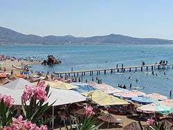 Burhaniye, Ören Beach | |
 Location of Burhaniye within Turkey. | |
 Burhaniye Location of Burhaniye within Turkey. | |
| Coordinates: 39°30′N 26°57′E | |
| Country | |
| Region | Aegean |
| Province | Balıkesir |
| Government | |
| • Mayor | Ali Kemal Deveciler (CHP) |
| Area | |
| • District | 279.96 km2 (108.09 sq mi) |
| Population (2012)[2] | |
| • Urban | 41,918 |
| • District | 52,787 |
| • District density | 190/km2 (490/sq mi) |
| Time zone | UTC+2 (EET) |
| • Summer (DST) | UTC+3 (EEST) |
| Area code(s) | 266 |
| Licence plate | 100 |
| Website | www |
Burhaniye has a port and a museum of archeology. A museum for the Turkish National Movement was inaugurated in 2008 under the name Burhaniye Kuvay-ı Milliye Müzesi.[3]
A biennial festival, Ören Tourism and Art Festival, is organized in July.
History
Burhaniye was founded as Taylıeli ('Town of Taylı') village, named after one of the Turkish beys who came to the aid of Seljuk ruler Süleyman. At the beginning of the 14th century it came under the domain of the Karasids and grew as it attracted migrants. In Ottoman times, it was also known as Kemer and attached to Edremit until 1866 and became the centre of a district named after itself. It was renamed Burhaniye after the Ottoman Prince Şehzade Burhanettin. According to the Ottoman General Census of 1881/82-1893, the kaza of Burhaniye had a total population of 19.595, consisting of 17.145 Muslims, 2.433 Greeks, 9 Armenians and 8 foreign citizens.[4]
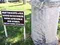
On 8 June 1922 the town was freed from Greek occupation. As the Greeks were retreating they intended to burn and destroy the town center, however this was prevented by Borazan Çavuş from Pelitköy, who climbed on a minaret and when he saw the Greek enemy units approaching, played the attack tune on his Bugle. He tricked the Greeks into thinking that the town center had a Turkish military presence and thus the Greeks continued their retreat without entering the town center and it was saved from destruction.[5] In front of the Atatürk statue there is a monument with a sculpture of a rifle and bugle in commemoration of Borazan Çavuş and the Kuva-yi Milliye. Until 1992 there was also a sculpture by Gürdal Duyar depicting Borazan Çavuş.
Burhaniye is 4 kilometres east of the site of ancient Adramyttium, which was later moved 13 kilometres northeast to Edremit.[6] Its history is described in the article on the modern town, which has inherited the name of the old.
Twin towns — sister cities
Burhaniye is twinned with:[7]


Gallery
- Ören Beach, Burhaniye
 Archeological site in Burhaniye
 Ören
Ören Pelitköy holiday village
 Burhaniye Memorial for Martyrs
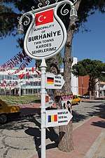 Twin towns of Burhaniye
See also
References
- "Area of regions (including lakes), km²". Regional Statistics Database. Turkish Statistical Institute. 2002. Retrieved 2013-03-05.
- "Population of province/district centers and towns/villages by districts - 2012". Address Based Population Registration System (ABPRS) Database. Turkish Statistical Institute. Retrieved 2013-02-27.
- http://www.haberturk.com/kultur-sanat/haber/110924-burhaniyede-kuvayi-milliye-muzesi-acildi
- Kemal Karpat (1985), Ottoman Population, 1830-1914, Demographic and Social Characteristics, The University of Wisconsin Press, p. 132-133
- "Borazan İsmail Çavuş". ORJAN TATİL SİTESİ. Retrieved 1 September 2017.
- Mordtmann, J. H.; Ménage, V. L.. "Edremit." Encyclopédie de l’Islam. Brill Online, 2014. Reference. 30 September 2014
- "Kardeş Belediyeler". burhaniye.bel.tr (in Turkish). Burhaniye. Retrieved 2020-01-21.
External links
| Wikimedia Commons has media related to Burhaniye, Balıkesir. |
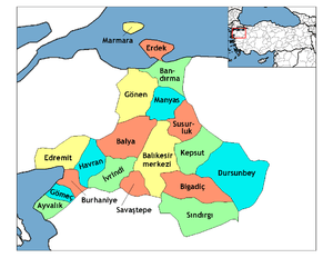
Burhaniye in Balıkesir Province of Turkey | |||||||||||||||||||||||||||
|---|---|---|---|---|---|---|---|---|---|---|---|---|---|---|---|---|---|---|---|---|---|---|---|---|---|---|---|
| Districts | Districts of Balıkesir | ||||||||||||||||||||||||||
| |||||||||||||||||||||||||||
Metropolitan municipalities are bolded. | |||||||||||||||||||||||||||