Boigu Island (Queensland)
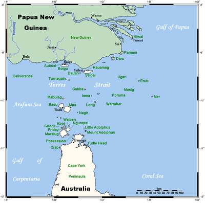
Boigu Island (also known as Malu Kiyay or Malu Kiwai[1]) is the most northerly inhabited island of Queensland and of Australia.[2] It is part of the top-western group of the Torres Strait Islands, which lie in the Torres Strait separating Cape York Peninsula from the island of New Guinea. The mainland of Papua New Guinea is only 6 kilometres (3.7 mi) away from Boigu. Boigu has an area of 89.6 square kilometres (34.6 sq mi). Boigu is also the name of the town and Boigu Island is the name of the locality on the island within the Torres Strait Island Region.[3][4]
 Boigu within the Torres Strait Islands | |
 Boigu Boigu Island (Queensland, Australia) | |
| Geography | |
|---|---|
| Location | Torres Strait |
| Coordinates | 09°16′S 142°13′E |
| Archipelago | Torres Strait Islands |
| Area | 89.6 km2 (34.6 sq mi) |
| Length | 18.12 km (11.259 mi) |
| Width | 5.05 km (3.138 mi) |
| Highest elevation | 18 m (59 ft) |
| Highest point | unnamed |
| Administration | |
Australia | |
| State | Queensland |
| Shire | Shire of Torres |
| Island Region | Top Western |
| Largest settlement | Boigu (pop. 270) |
| Demographics | |
| Population | 270 (2001) |
| Pop. density | 3.0/km2 (7.8/sq mi) |
| Ethnic groups | Torres Strait Islanders |
| Boigu / Boigu Island Queensland | |
|---|---|
 Boigu / Boigu Island | |
| Coordinates | 9°13′56″S 142°13′06″E |
| LGA(s) | Torres Strait Island Region |
It is the largest and only inhabited island of the Talbot Islands group of the Torres Strait Islands.
Language and affiliations
The language of Boigu is that of the Western and Central Islands of the Torres Strait. The specific dialect is Kalau Kawau Ya, also spoken on the islands of Dauan and Saibai. The people of the three islands consider themselves as one people.
Kala Kawaw Ya (also known as Kalaw Kawaw, KKY) is one of the languages of the Torres Strait. Kala Kawaw Ya is the traditional language owned by the Top Western islands of the Torres Strait. The Kala Kawaw Ya language region includes the landscape within the local government boundaries of the Torres Shire Council.[5]
History
Boigu was visited by South Sea Islander missionaries of the London Missionary Society, some time after the establishment of a mission on nearby Saibai Island in 1871.
From the 1870s to around 1910, the Boigu, Dauan and Saibai people, along with the neighbouring Papuan peoples, were being harassed by thugeral "warriors" from the Marind-anim, fierce headhunters from what is now southeast West Papua. In literature dealing with the period, these people are generally termed 'Tuger' or 'Tugeri'. Sir William MacGregor, the Lieutenant-Governor of British New Guinea, noted in 1886 that the population was nearly extinct as a result of these raids. What he did not realise was that at the time the bulk of the population were staying with family on Saibai and Dauan for mutual protection.
Geography
Boigu is approximately 18 kilometres (11 mi) long, and low-lying. It was formed by the accumulation of alluvial sediments deposited by the discharge of nearby New Guinean rivers into the Strait. These sediments built up over time on an old coral platform which rises from the shallow continental shelf, eventually creating the island.
Most of the island is subject to extensive periodic flooding, and as a result the community township has been built on the highest ground.
.png)
Two nearby smaller islands (not permanently settled) are considered as a part of Boigu island, more accurately of the Talbot Islands, these are Aubusi Island and Moimi Island.
Ecology
The island is considered part of the New Guinea mangroves ecoregion, a subset of the Australasian realm.
The interior of the island is sparsely vegetated, and mainly swampland. The coast is fringed by mangroves, which act to protect against the island's sand and mud from sea erosion.
It is likely the mangrove regions harbour healthy populations of saltwater crocodile.
The waters surrounding the island are an important habitat for dugongs, a species of sea mammal listed as vulnerable by the IUCN.
Population
Boigu is predominantly inhabited by indigenous Torres Strait Islanders. According to 2004 Torres Strait Regional Authority (TSRA) figures, its resident population is approximately 340. Currently there are approximately 260 people living on the island (2008).
The village of Boigu at the northern end of the island is the northernmost settlement of Australia. The northernmost island, however, is Bramble Cay, 173 kilometres (107 mi) to the east.
Amenities
The Torres Strait Island Regional Council operate an Indigenous Knowledge Centre at 66 Chamber Street.[6]
Education
Tagai State College - Malu Kiwai Island Campus opened on 1 January 2007. It was formerly known as Malu Kiwai State School before the amalgamation of 17 Torres Strait Island Schools to form Tagai State College.[7]
References
- "Archived copy". Archived from the original on 14 July 2014. Retrieved 8 July 2014.CS1 maint: archived copy as title (link)
- "Boigu Island - island (entry 3484)". Queensland Place Names. Queensland Government. Retrieved 8 March 2017.
- "Boigu - town (entry 3483)". Queensland Place Names. Queensland Government. Retrieved 8 March 2017.
- "Boigu Island - locality (entry 46701)". Queensland Place Names. Queensland Government. Retrieved 8 March 2017.
-

- "Boigu". Public Libraries Connect. State Library of Queensland. 28 August 2017. Archived from the original on 31 January 2018. Retrieved 31 January 2018.
- "Opening and closing dates of Queensland Schools". Queensland Government. Retrieved 18 April 2019.
External links
List of Torres Strait topics | |||||||||||||||||||
|---|---|---|---|---|---|---|---|---|---|---|---|---|---|---|---|---|---|---|---|
| Torres Strait Islands, islets, and cays |
| ||||||||||||||||||
| People, culture, communities and languages |
| ||||||||||||||||||
| Governance and legal matters |
| ||||||||||||||||||
| Buildings and structures | |||||||||||||||||||
| Other | |||||||||||||||||||
| Authority control |
|
|---|