Mountains of the Central Dingle Peninsula
The Mountains of the Central Dingle Peninsula are the generic name given to the mountains that lie on the Dingle Peninsula between the Brandon Group of mountains in the west, and the Slieve Mish Mountains at the eastern end of the peninsula.[2]
| Mountains of the Central Dingle Peninsula | |
|---|---|
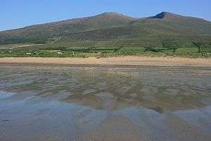 Beenoskee and Stradbally Mountain from Gowlane Strand | |
| Highest point | |
| Peak | Beenoskee |
| Elevation | 826 m (2,710 ft) [1] |
| Prominence | 491 m (1,611 ft) [1] |
| Coordinates | 52°12′50″N 10°04′39″W [1] |
| Dimensions | |
| Length | 20 km (12 mi) E/W |
| Width | 11 km (6.8 mi) N/S |
| Geography | |
 Mountains of the Central Dingle Peninsula Location of Slieve Mish Mountains | |
| Location | Kerry |
| Country | Republic of Ireland |
| Provinces of Ireland | Munster |
| Topo map | OSI Discovery 71/70 |
| Geology | |
| Age of rock | Devonian[1] |
| Type of rock | Purple cross-bedded sandstone[1] |
Geology
Like many of the mountain ranges in Kerry, such as the MacGillycuddy Reeks, the mountains of the Central Dingle peninsula are composed predominantly of Devonian period Old Red Sandstone, with a band of Ordovician period metasediments.[3][4]
The rocks date from the Upper Devonian period (310–450 million years ago) when Ireland was in a hot equatorial setting.[5] During this 60 million year period, Ireland was the site of a major basin, known as the Munster basin, and Cork and Kerry were effectively a large alluvial floodplain.[5] Chemical oxidation stained the material with a purple–reddish colour (and green in places from chlorination), still visible today.[5] There are virtually no fossils in Old Red Sandstone.[5]
The composition of Old Red Sandstone is variable and includes sandstones, mudstones, siltstones, and conglomerates (boulders containing quartz pebbles are visible throughout the range).[5] The mountains were subject to significant glaciation with corries and U-shaped valleys, however the range does not have the sharp rocky arêtes and ridges of the MacGillycuddy Reeks range.[5]
List of peaks
The following is a download from the MountainViews Online Database, who list 23 identifiable Central Dingle peaks with an elevation, or height, above 100 metres
| Height Rank |
Prom. Rank |
Name | Irish Name (if different) | Translation | Height (m) |
Prom. (m) |
Height (ft) |
Prom. (ft) |
Topo Map |
OSI Grid Reference |
|---|---|---|---|---|---|---|---|---|---|---|
| 1 | 1 | Beenoskee | Binn os Gaoith | Mountain above the Wind/Estuary[lower-alpha 1] | 826 | 491 | 2,710 | 1,611 | 70 | Q580089 |
| 2 | 20 | Stradbally Mountain | Cnoc an tSráidbhaile | Hill of Stradbally | 798 | 40 | 2,618 | 131 | 70 | Q587092 |
| 3 | 2 | Slievanea NE Top | — | — | 671 | 265 | 2,200 | 869 | 70 | Q515064 |
| 4 | 12 | An Cnapán Mór | — | The Big Lump[lower-alpha 2] | 649 | 81 | 2,129 | 266 | 70 | Q522045 |
| 5 | 6 | Cnoc na Bánóige[lower-alpha 3] | — | Hill of the Grassy Patch | 642 | 176 | 2,105 | 577 | 70 | Q548048 |
| 6 | 21 | Slievanea | Sliabh Macha Ré | Mountain of the Smooth Plain[lower-alpha 4] | 629 | 22 | 2,063 | 73 | 70 | Q508057 |
| 7 | 19 | Coombane[lower-alpha 5] | An Com Bán | The White Hollow | 610 | 42 | 2,001 | 138 | 70 | Q568092 |
| 8 | 23 | Croaghskearda | Cruach Sceirde | Stack of the Exposed Place[lower-alpha 6] | 608 | 13 | 1,995 | 43 | 70 | Q509039 |
| 9 | 18 | Knockmulanane | Cnoc Mhaoilionáin | Mulfinan's hill | 593 | 48 | 1,946 | 157 | 70 | Q568049 |
| 10 | 15 | Beenatoor | Binn an Tuair | Peak of the Bleaching Green | 592 | 66 | 1,942 | 217 | 70 | Q559089 |
| 11 | 22 | Knockmulanane West Top | — | — | 563 | 15 | 1,847 | 49 | 70 | Q560048 |
| 12 | 5 | Dromavally Mountain | Cnoc Dhroim an Bhaile | Hill of Dromavally[lower-alpha 7] | 552 | 206 | 1,811 | 676 | 71 | Q606067 |
| 13 | 9 | Sliabh na nGabhar[lower-alpha 8] | — | Mountain of the Goats | 486 | 120 | 1,594 | 394 | 70 | Q539072 |
| 14 | 7 | Cummeen[lower-alpha 9] | Sliabh an Choimín | Mountain of the Little Hollow | 477 | 162 | 1,565 | 531 | 71 | Q630077 |
| 15 | 17 | Gob an Iolair[lower-alpha 10] | — | Beak of the eagle | 477 | 48 | 1,564 | 158 | 70 | Q545074 |
| 16 | 14 | An Starraicín | — | The Steeple[lower-alpha 11] | 458 | 71 | 1,504 | 233 | 70 | Q528064 |
| 17 | 16 | Cnoc na Bánóige N Top | — | 448 | 52 | 1,469 | 170 | 70 | Q552061 | |
| 18 | 13 | Knocknakilton | (unknown)[lower-alpha 12] | (unknown)[lower-alpha 12] | 423 | 79 | 1,388 | 259 | 71 | Q638062 |
| 19 | 4 | Brickany[lower-alpha 13] | Breicneach | Speckled Place | 374 | 219 | 1,227 | 719 | 71 | Q632022 |
| 20 | 3 | Knocknanacree | Cnoc na nAcraí | hill of na hAcraí/Acres[lower-alpha 14] | 286 | 260 | 938 | 853 | 70 | V572998 |
| 21 | 8 | Doonties Commons | (unknown) | (unknown) | 252 | 136 | 827 | 446 | 70 | V502987 |
| 22 | 11 | Carrigadav | (unknown) | (unknown) | 240 | 96 | 787 | 315 | 71 | Q626097 |
| 23 | 10 | Farrendalouge | (unknown) | (unknown) | 144 | 97 | 472 | 318 | 70 | Q546115 |
See also
- Brandon Group, a mountain range in Dingle Peninsula
- Slieve Mish Mountains, a mountain range in Dingle Peninsula
- Lists of mountains in Ireland
- List of mountains of the British Isles by height
- List of P600 mountains in the British Isles
- List of Marilyns in the British Isles
- List of Hewitt mountains in England, Wales and Ireland
Notes
- This name is locally understood to mean 'mountain above the wind', but as wind speeds tend only to increase the more height one gains, one has to ask what this could possibly mean. Another possibility is that gaoth is rather an archaic word for a water feature (possibly Lough Gill or the estuary of the nearby Owenmore River), and that the name was no longer understood once this word had fallen out of common use.[2]
- An Seabhac also gives the alternative name An Sliabh Dubh ("the black mountain"). Previously Gowlane Beg.[2]
- Also known as Banoge North.[2]
- The anglicised form Slievanea would appear to derive from Ir. Sliabh an Fhia, 'mountain of the deer'. The deer is also an important symbol in Celtic mythology. In many tales they lure people into the realm of the gods. Remains of several fulachta fia (venison-cooking pits) can be found around Lough Adoon.[2]
- Marked as 'Coombane' on the 6 map. The name refers originally to a hollow in the upper reaches of Kilcummin Beg townland.[2]
- Near a path over the brow of the hill between Gowlin and Lisdargan there is an underground passage called Staighre Chaitlín (Cathleen's Stairs) which leads to a cave.[2]
- Three cairns on the summit ridge of Dromavally Mountain are named Cú Chulainn's House, Cú Chulainn's Bed and Cú Chulainn's Grave.[2]
- The Irish form is given as Slí na gCorr on the OS Discovery map. However, this is clearly not the name of a mountain. It either refers to a track or is perhaps a corruption of Sliabh na nGabhar.[2]
- An Seabhac also mentions a peak called An Bhinn Bháin above Lough Acummeen, but this may refer to a cliff rather than the summit.[2]
- Since Beenbo is clearly a separate name (probably from Ir. Binn Bó, 'peak of the cow'), it seems likely that it is the true name of the summit, while Gob an Iolair applies originally to the sharp point just N of the summit.[2]
- This peak earns its name with its pointed peak.[2]
- This name is not mentioned by An Seabhac in TCCD. It is unclear what the second element is.[2]
- This hill, located in the townland of Ballynane, is unnamed on OS Discovery map but named on the old ½ series and on road atlases. Has been called Tullig.[2]
- Acres (na hAcraí) is a townland name.[2]
References
- "Beenoskee". MountainViews Online Database. Retrieved 8 February 2019.
- Paul Tempan (February 2012). "Irish Hill and Mountain Names" (PDF). MountainViews.ie.
- "Site Name: Slieve Mish Mountains (Special Area of Conservation)" (PDF). Department of Arts Heritage and the Gaeltacht. 20 July 2016. Retrieved 20 July 2019.
- "Slieve Mish Mountains SAC" (PDF). National Parks and Wildlife Service (Ireland). September 2017. Retrieved 20 July 2019.
- Ryan, Jim (2006). Carrauntoohil and MacGillycuddy's Reeks: A Walking Guide to Ireland's Highest Mountains. Collins Press. ISBN 978-1905172337.
Mountains and hills of Munster | |||||||
|---|---|---|---|---|---|---|---|
| Ballyhoura Mountains | 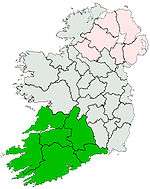 | ||||||
| Boggeragh Mountains | |||||||
| Caha Mountains | |||||||
| Comeragh Mountains | |||||||
| Derrynasaggart Mountains | |||||||
| Dingle Peninsula |
| ||||||
| Galty Mountains | |||||||
| Iveragh Peninsula | |||||||
| Knockmealdown Mountains | |||||||
| MacGillycuddy's Reeks |
| ||||||
| Mangerton Mountains | |||||||
| Shehy Mountains | |||||||
| Silvermine Mountains | |||||||
| Slieve Miskish Mountains | |||||||
| Others |
| ||||||