Slieve Mish Mountains
Slieve Mish Mountains (Irish: Sliabh Mis, meaning "[possibly] mountains of Mis"),[4] is a predominantly sandstone mountain range at the eastern end of the Dingle Peninsula in County Kerry, Ireland. Stretching 19 kilometres (12 miles), from the first major peak of Barnanageehy outside of Tralee in the east, to Cnoc na Stuaice in near Central Dingle in the west, the range has over 17 material peaks (e.g. height above 100 m), with the core of the mountain range based around the massif of its highest peak, Baurtregaum, and its deep glacial valleys of Derrymore Glen and Curraheen Glen.
| Slieve Mish Mountains | |
|---|---|
| Irish: Sliabh Mis | |
 Slieve Mish Mountains from across the Tralee Bay in the village of Fenit | |
| Highest point | |
| Peak | Baurtregaum[1][2] |
| Elevation | 851 m (2,792 ft) [1][2] |
| Coordinates | 52°12′N 9°46′W |
| Dimensions | |
| Length | 19 km (12 mi) East–West |
| Width | 6 km (3.7 mi) |
| Area | 97.9[3] km2 (37.8 sq mi) |
| Naming | |
| English translation | [possibly] mountains of Mis |
| Language of name | Irish |
| Geography | |
 Slieve Mish Mountains Location of Slieve Mish Mountains | |
| Location | Kerry |
| Country | Republic of Ireland |
| Provinces of Ireland | Munster |
| Topo map | OSI Discovery 71 |
| Geology | |
| Age of rock | Devonian[2] |
| Type of rock | Purple cross-bedded sandstone[2] |
Naming
The Irish language term "Sliabh" denotes a mountain, however, the precise meaning of "Mis" has not been validated. Irish academic Paul Tempan notes that it could be related to Slemish mountain in County Antrim, where the term "Mis" is from a female name, and thus translates as "the mountains of Mis".[4]
Geology
Like many of the mountain ranges in Kerry, such as the MacGillycuddy Reeks, the Slieve Mish Mountains are composed predominantly of Devonian period Old Red Sandstone, with a band of Ordovician period metasediments on the western slopes of the range.[3][1]
The rocks date from the Upper Devonian period (310–450 million years ago) when Ireland was in a hot equatorial setting.[5] During this 60 million year period, Ireland was the site of a major basin, known as the Munster basin, and Cork and Kerry were effectively a large alluvial floodplain.[5] Chemical oxidation stained the material with a purple–reddish colour (and green in places from chlorination), still visible today.[5] There are virtually no fossils in Old Red Sandstone.[5]
The composition of Old Red Sandstone is variable and includes sandstones, mudstones, siltstones, and conglomerates (boulders containing quartz pebbles are visible throughout the range).[5] The Slieve Mish range was also subject to significant glaciation with corries (e.g. the upper lakes of the Derrymore Glen), U-shaped valleys (e.g. the Derrymore Glen and the Curraheen Glen), however the range does not have the sharp rocky arêtes and ridges of the MacGillycuddy Reeks range.[5]
Geography
Overlooking Tralee Bay on the northern side and Dingle Bay on the south, the range extends for 19 kilometres from just outside Tralee in the east to the centre of the Dingle Peninsula in the west. The range is often described as the "backbone" of the Dingle Peninsula because of distribution of most of its major peaks along narrow south-west to north-east "spine" that extends to 6 kilometres at its widest part.[6][7]
The core of the range is the massif of its highest point Baurtregaum 851 metres (2,792 ft), and the main peaks of the range sit and Baurtregaum's high grassy ridge from Baurtregaum Far NW Top 603 metres (1,978 ft)in the east, to Caherconree 835 metres (2,740 ft), and Gearhane 792 metres (2,598 ft), in the west.
Bautregaum has two major glacial U-shaped valleys, the long 4.5-kilometre easterly Curraheen Glen (with the Curraheen River), and the shorter but deeper northerly Derrymore Glen (Derrymore River), with its three corrie lakes.[6][7]
After descending to the north-south mountain pass of Bóthar na gCloch ("road of the stones") to the west, the spine of the range rises up again at Knockbrack 459 metres (1,506 ft) and Lack Mountain 465 metres (1,526 ft), to run in a further south-westerly direction to finish at Cnoc na Stuaice 483 metres (1,585 ft).[6][7]
List of peaks
The following is a download from the MountainViews Online Database, who list 17 identifiable Slieve Mish peaks with an elevation, or height, above 100 metres
| Height Rank |
Prom. Rank |
Name | Irish Name (if different) | Translation | Height (m) |
Prom. (m) |
Height (ft) |
Prom. (ft) |
Topo Map |
OSI Grid Reference |
|---|---|---|---|---|---|---|---|---|---|---|
| 1 | 1 | Baurtregaum | Barr Trí gCom | Top of Three Hollows[lower-alpha 1] | 851 | 643 | 2,792 | 2,110 | 71 | Q749076 |
| 2 | 4 | Caherconree | Cathair Conraoi | Cú Roí’s Stone Fort[lower-alpha 2] | 835 | 129 | 2,740 | 423 | 71 | Q733073 |
| 3 | 17 | Baurtregaum NE Top | — | — | 819 | 14 | 2,687 | 46 | 71 | Q755081 |
| 4 | 16 | Gearhane | An Géarán | The Fang[lower-alpha 3] | 792 | 17 | 2,598 | 56 | 71 | Q733082 |
| 5 | 15 | Baurtregaum NW Top | — | — | 723 | 18 | 2,372 | 59 | 71 | Q747084 |
| 6 | 12 | Baurtregaum Far NE Top | — | — | 603 | 28 | 1,978 | 92 | 71 | Q768090 |
| 7 | 11 | Castle Hill[lower-alpha 4] | — | — | 600 | 35 | 1,969 | 115 | 71 | Q756063 |
| 8 | 6 | Caherbla | Cathair Bhláth | Stone Fort of Flowers[lower-alpha 5] | 586 | 91 | 1,923 | 299 | 71 | Q724052 |
| 9 | 2 | Moanlaur | Móin Láir | Middle Bog | 566 | 289 | 1,857 | 948 | 71 | Q690045 |
| 10 | 14 | Knockmore | An Cnoc Mór | The Big Hill | 565 | 27 | 1,854 | 89 | 71 | Q684042 |
| 11 | 7 | Barnanageehy | Bearna na Gaoithe | Gap of the wind[lower-alpha 6] | 561 | 56 | 1,841 | 184 | 71 | Q800082 |
| 12 | 8 | Beenduff | An Bhinn Dubh | The Black Peak | 515 | 40 | 1,690 | 131 | 71 | Q677037 |
| 13 | 13 | Cnoc na Stuaice[lower-alpha 7] | Cnoc na Stuaice | Hill of the Peak | 483 | 28 | 1,585 | 92 | 71 | Q666029 |
| 14 | 9 | Lack Mountain | Sliabh na Lice | Mountain of the Flagstone | 465 | 40 | 1,526 | 131 | 71 | Q706045 |
| 15 | 10 | Knockbrack | An Cnoc Breac | The Speckled Hill | 459 | 36 | 1,506 | 118 | 71 | Q702051 |
| 16 | 5 | Corrin | (unknown) | (unknown) | 332 | 97 | 1,089 | 318 | 71 | Q685075 |
| 17 | 3 | Knockafeehane | (unknown) | (unknown) | 301 | 130 | 988 | 427 | 71 | Q616014 |
See also
| Wikimedia Commons has media related to Slieve Mish Mountains. |
- Brandon Group, a mountain range in Dingle Peninsula
- Mountains of the Central Dingle Peninsula, a mountain range in Dingle Peninsula
- Lists of mountains in Ireland
- List of mountains of the British Isles by height
- List of P600 mountains in the British Isles
- List of Marilyns in the British Isles
- List of Hewitt mountains in England, Wales and Ireland
Notes
- The three hollows in question are probably the valleys of Derrymore, Derryquay and Curraheen, which cut into the sides of the mountain.[4]
- Caherconree is named after a stone fort situated two-thirds of the way up its western flank, overlooking the mountain road called Bóthar na gCloch ('road of the stones'). This is an inland promontory-fort, consisting of a natural projecting ledge surrounded on three sides by steep cliffs, the fourth side being defended by a stone wall.[4]
- Between Gearhane and the summit of Caherconree are two rock features known as Finn Mac Cool's Table and Finn Mac Cool's Chair.[4]
- As this peak is rather far from any castle (at Castledrum or Castlemaine), it may be simply named from its commanding position.[4]
- An Seabhac reports hearing from a shanachee that the correct name was Cathair Bhláthnaide, 'Bláthnaid's stone fort'. Bláthnaid was the daughter of the king of the Isle of Man. Cú Chulainn and Cú Roí fell out over who would have her hand. See also Caherconree.[4]
- This is one of the most common names for a pass in Ireland. The name is actually marked on lower peaks to the E, and it seems likely that the gap in question is even further to the E.[4]
- Also recorded as "Emlagh".[4]
References
- "Site Name: Slieve Mish Mountains (Special Area of Conservation)" (PDF). Department of Arts Heritage and the Gaeltacht. 20 July 2016. Retrieved 20 July 2019.
- "Baurtregaum". MountainViews Online Database. Retrieved 8 February 2019.
- "Slieve Mish Mountains SAC" (PDF). National Parks and Wildlife Service (Ireland). September 2017. Retrieved 20 July 2019.
- Paul Tempan (February 2012). "Irish Hill and Mountain Names" (PDF). MountainViews.ie.
- Ryan, Jim (2006). Carrauntoohil and MacGillycuddy's Reeks: A Walking Guide to Ireland's Highest Mountains. Collins Press. ISBN 978-1905172337.
- "Site Report No. 15: Slieve Mish Mountains cSAC (002185), Co. Kerry" (PDF). National Parks and Wildlife Service (Ireland). 2014. Retrieved 20 July 2019.
- Mountainviews, (September 2013), "A Guide to Ireland's Mountain Summits: The Vandeleur-Lynams & the Arderins", Collins Books, Cork, ISBN 978-1-84889-164-7
| British Isles |  | |
|---|---|---|
| Scotland | ||
| Outside Scotland | ||
| England | ||
| Ireland | ||
| County tops | ||
Mountains and hills of Munster | |||||||
|---|---|---|---|---|---|---|---|
| Ballyhoura Mountains | 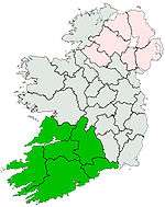 | ||||||
| Boggeragh Mountains | |||||||
| Caha Mountains | |||||||
| Comeragh Mountains | |||||||
| Derrynasaggart Mountains | |||||||
| Dingle Peninsula |
| ||||||
| Galty Mountains | |||||||
| Iveragh Peninsula | |||||||
| Knockmealdown Mountains | |||||||
| MacGillycuddy's Reeks |
| ||||||
| Mangerton Mountains | |||||||
| Shehy Mountains | |||||||
| Silvermine Mountains | |||||||
| Slieve Miskish Mountains | |||||||
| Others |
| ||||||