Biga, Çanakkale
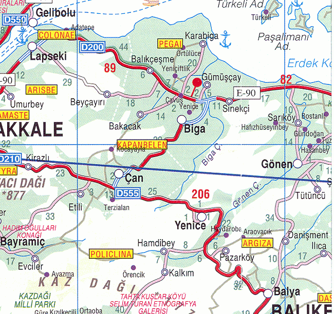
Biga is a town and district of Çanakkale Province in the Marmara region of Turkey. It is located on the Biga River, 90 kilometres (56 miles) northeast from Çanakkale city centre. According to the 2000 census, population of the district is 80,982 of which 37,196 live in the town of Biga.[3][4] The district covers an area of 1,354 km2 (523 sq mi),[5] and the town lies at an elevation of 21 m (69 ft).
Biga | |
|---|---|
District | |
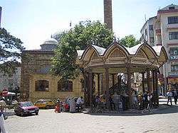 Central square in Biga | |
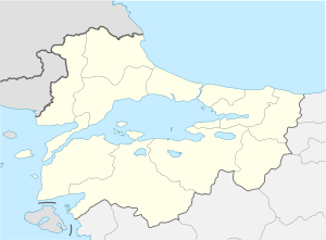
 Location of Biga within Turkey | |
 Biga Location of Biga  Biga Biga (Turkey) | |
| Coordinates: 40°14′N 27°15′E | |
| Country | |
| Region | Marmara |
| Province | Çanakkale |
| Government | |
| • Governor | Fatih Genel |
| • Mayor | Bülent Erdoğan (AKP) |
| Area | |
| • District | 1,353.69 km2 (522.66 sq mi) |
| Elevation | 21 m (69 ft) |
| Population (2012)[2] | |
| • Urban | 40,637 |
| • District | 83,594 |
| • District density | 62/km2 (160/sq mi) |
| Time zone | UTC+2 (EET) |
| • Summer (DST) | UTC+3 (EEST) |
| Postal code | 17xxx |
| Area code(s) | 286 |
| Licence plate | 17 |
| Website | www.biga.gov.tr www.biga.bel.tr |
The center of COMU Faculty of Economics and Administrative Sciences is in Biga.
History
Within the area of Biga (at Karabiga) is the site of the ancient city of Pegaea (Greek: Πηγαία), also known as Pegae or Pegai (Πηγαί, "the Springs") until late Byzantine times (in Crusader sources it is also known as Spiga[6]). Archaeologists have not yet established how far back the site has been occupied.[7] In ancient times, Pegaea, located on the plain of Adrastea on the border between the Troad and Mysia, was sometimes included as part of one and sometimes the other. Since coming under Ottoman rule in 1364 it has been known as Biga. Under the Ottomans, it was the seat of a sanjak.
Tourism
Among the tourist sites in the district are the Ilıcabashı spa, Parion (Kemerd), Priapos (Karabiga castle)[7]
International relations
See also
Gallery
 Biga panorama from Balıkkaya
 Kocakum shores in Karabiga
 Biga Çayı (Granicus River) in Biga
Notes
- "Area of regions (including lakes), km²". Regional Statistics Database. Turkish Statistical Institute. 2002. Retrieved 2013-03-05.
- "Population of province/district centers and towns/villages by districts - 2012". Address Based Population Registration System (ABPRS) Database. Turkish Statistical Institute. Retrieved 2013-02-27.
- Statistical Institute
- GeoHive. "Statistical information on Turkey's administrative units". Retrieved 2009-04-24.
- Statoids. "Statistical information on districts of Turkey". Retrieved 2009-04-20.
- TDV İslâm Ansiklopedisi
- "Başmakçı Kültür (Bashmakchi Culture)"
- "Twinnings" (PDF). Central Union of Municipalities & Communities of Greece. Retrieved 2013-08-25.
References
- Falling Rain Genomics, Inc. "Geographical information on Biga, Turkey". Retrieved 2009-04-24.
External links
![]()
- District governor's official website (in Turkish)
- Road map of Biga and environs
- Detailed map of Biga district of Çanakkale
- Various images of Biga, Çanakkale
- Various images of Karabiga in Biga, Çanakkale
- Information on Biga (in Turkish)
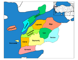
Biga, Çanakkale in Çanakkale Province of Turkey | |||||||||||||||||||||||||||
|---|---|---|---|---|---|---|---|---|---|---|---|---|---|---|---|---|---|---|---|---|---|---|---|---|---|---|---|
| Districts | Districts of Çanakkale | ||||||||||||||||||||||||||
| |||||||||||||||||||||||||||
Metropolitan municipalities are bolded. | |||||||||||||||||||||||||||