Bear Cove ferry terminal
The Bear Cove ferry terminal is a ferry port on Vancouver Island in British Columbia, Canada. It is located on the Queen Charlotte Strait, near the district municipality of Port Hardy in the Regional District of Mount Waddington. It provides connections to British Columbia's Central and Northern coasts. The tidal range of the Queen Charlotte Strait is normally between 2 and 6 metres (7–20 ft).[2] The ferry terminal is the northern terminus of Highway 19.
Bear Cove ferry terminal | |
|---|---|
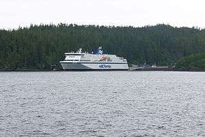 Bear Cove Terminal seen from the sea. | |
| Location | 6800 Highway 19, Port Hardy, BC |
| Coordinates | 50°43′31.6″N 127°27′21.9″W |
| Owned by | BC Ferries |
| Operated by | BC Ferries |
| Line(s) | Route 10–Prince Rupert Route 40–Discovery Coast Connector |
| History | |
| Opened | 1984[1] |
Routes
BC Ferries (British Columbia Ferry Services Inc.), the main operator of ferry services on the west coast of British Columbia, operates the following routes:
- Route 10 – Inside Passage: Port Hardy to Prince Rupert (winter stops at Bella Bella and Klemtu)[1][3]
- Route 40 – Discovery Coast Connector (summer only): Port Hardy to Bella Coola (with stops at Bella Bella, Shearwater, Klemtu, and Ocean Falls)[4]
See also
References
- "BEAR COVE (PORT HARDY) TERMINAL (Routes 10 & 40)" (PDF). BC Ferries. Retrieved 2016-11-05.
- "7 days Tidal Predictions: Port Hardy". Fisheries and Oceans Canada. Government of Canada. Retrieved March 13, 2017.
- "Inside Passage-Mid Coast-Bella Coola and Haida Gwaii Schedules". BC Ferries. Retrieved March 14, 2017.
- "Discovery Coast Connector". BC Ferries. Retrieved March 14, 2017.
This article is issued from Wikipedia. The text is licensed under Creative Commons - Attribution - Sharealike. Additional terms may apply for the media files.