Alert Bay
Alert Bay is a village on Cormorant Island, in the Regional District of Mount Waddington, British Columbia, Canada. 1,200-1,500 people live within the village.[2]
Alert Bay | |
|---|---|
| The Corporation of the Village of Alert Bay[1] | |
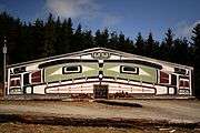 The big house near Alert Bay. | |
 Alert Bay Location within British Columbia  Alert Bay Alert Bay (Canada) | |
| Coordinates: 50°34′57″N 126°55′31″W | |
| Country | Canada |
| Province | British Columbia |
| Region | Central Coast |
| Regional district | Mount Waddington |
| Incorporated | 1946 |
| Government | |
| • Governing body | Alert Bay Village Council |
| • MP | Rachel Blaney (NDP) |
| • MLA | Claire Trevena (BC NDP) |
| Area | |
| • Total | 1.78 km2 (0.69 sq mi) |
| Elevation | 30 m (100 ft) |
| Population | |
| • Total | 489 |
| • Density | 270/km2 (710/sq mi) |
| Time zone | UTC-8 (PST) |
| Highways | Ferry to Port McNeill and Sointula |
| Waterways | Johnstone Strait, Broughton Strait, Cormorant Channel |
| Climate | Cfb |
| Website | Village of Alert Bay |
Population
Up to a half of the village's residents are First Nations people.[2] The village is in traditional Kwakwaka'wakw territory. Two Indian Reserves take up the rest of Cormorant Island, Alert Bay 1 on the east side of the island,[3] Alert Bay 1A on the west.[4]
Facilities and features
Alert Bay has a credit union, grocery store, museums, a traditional "big house", a hospital, an RCMP station, a drug store, a post office, three restaurants and retail gift shops, a BC liquor store, a Royal Canadian Legion, a pub, doctors' offices, a dental clinic, a drug and alcohol treatment centre, and 4 automated teller machines (one in the bank, legion hall, restaurant and one inside Bayside Pub).
The town has three airports (Alert Bay Airport, a public airport, and the Alert Bay Water Aerodrome). There is a boat harbour and a BC Ferries terminal with service to Sointula and Port McNeill.
There is an elementary school (Alert Bay Elementary School for children in kindergarten and grades 1 to 7 and the T'lisalagi'lakw School (independent) owned and operated by the 'Namgis First Nation for children in Nursery, Kindergarten and grades 1 to 7. Students in Grades 8 to 12 travel by foot or ferry/water taxi to a school in nearby Port McNeill on Vancouver Island, along with students from Sointula on nearby Malcolm Island and others on North Island.
There is also one campground and an ecological park consisting of a cedar swamp and a small area of old-growth trees.
Alert Bay is home to the world's tallest totem pole.[5]
U'mista Cultural Centre
In 1921, the Government of Canada, in an effort to stop the potlatch custom of dance, song, and wealth distribution under Section 116 of the Indian Act, confiscated many items including wooden masks, copper shields, and dance regalia. During the 1970s and 80s, the Kwakwaka'wakw regained their possessions after long negotiations. The returned artifacts are housed in a museum at the U'mista Cultural Centre.[6]
Origin of the name
The settlement was named c.1860 after the Royal Navy ship HMS Alert, which conducted survey operations in the area.[7]
Climate
Alert Bay has an oceanic climate (Köppen Cfb) with a strong drying tendency in summer. Alert Bay is heavily moderated by the proximity to the Pacific Ocean and being located in the pathway of low-pressure systems from said ocean, heavy annual rainfall ensues. Winter is the wettest season, but snowfall is rare due to the average lows above freezing.
| Climate data for Alert Bay | |||||||||||||
|---|---|---|---|---|---|---|---|---|---|---|---|---|---|
| Month | Jan | Feb | Mar | Apr | May | Jun | Jul | Aug | Sep | Oct | Nov | Dec | Year |
| Record high humidex | 13.6 | 16.1 | 19.5 | 23.3 | 38.9 | 30.6 | 35.0 | 35.1 | 29.5 | 31.8 | 18.3 | 14.4 | 38.9 |
| Record high °C (°F) | 13.9 (57.0) |
16.7 (62.1) |
18.7 (65.7) |
23.5 (74.3) |
35.2 (95.4) |
30.0 (86.0) |
29.4 (84.9) |
33.3 (91.9) |
27.9 (82.2) |
23.9 (75.0) |
17.8 (64.0) |
15.6 (60.1) |
35.2 (95.4) |
| Average high °C (°F) | 6.1 (43.0) |
7.0 (44.6) |
9.6 (49.3) |
11.4 (52.5) |
14.3 (57.7) |
15.8 (60.4) |
18.0 (64.4) |
18.4 (65.1) |
16.0 (60.8) |
11.8 (53.2) |
7.4 (45.3) |
5.4 (41.7) |
11.8 (53.2) |
| Daily mean °C (°F) | 4.3 (39.7) |
4.6 (40.3) |
6.3 (43.3) |
7.7 (45.9) |
10.4 (50.7) |
12.2 (54.0) |
14.1 (57.4) |
14.4 (57.9) |
12.2 (54.0) |
9.0 (48.2) |
5.5 (41.9) |
3.6 (38.5) |
8.7 (47.7) |
| Average low °C (°F) | 2.4 (36.3) |
2.2 (36.0) |
3.0 (37.4) |
4.0 (39.2) |
6.4 (43.5) |
8.5 (47.3) |
10.2 (50.4) |
10.4 (50.7) |
8.3 (46.9) |
6.1 (43.0) |
3.5 (38.3) |
1.8 (35.2) |
5.6 (42.1) |
| Record low °C (°F) | −11.1 (12.0) |
−13.6 (7.5) |
−7.8 (18.0) |
−1.7 (28.9) |
0.0 (32.0) |
2.2 (36.0) |
1.1 (34.0) |
5.6 (42.1) |
1.1 (34.0) |
−3.9 (25.0) |
−12.6 (9.3) |
−13.3 (8.1) |
−13.6 (7.5) |
| Record low wind chill | −21.5 | −26.5 | −22.0 | −4.0 | 0.0 | 0.0 | 0.0 | 0.0 | 0.0 | −9.2 | −24.8 | −23.0 | −26.5 |
| Average precipitation mm (inches) | 215.9 (8.50) |
149.9 (5.90) |
109.7 (4.32) |
103.4 (4.07) |
78.3 (3.08) |
79.1 (3.11) |
45.4 (1.79) |
62.3 (2.45) |
76.8 (3.02) |
209.9 (8.26) |
249.6 (9.83) |
193.3 (7.61) |
1,573.5 (61.95) |
| Average rainfall mm (inches) | 210.2 (8.28) |
138.9 (5.47) |
108.4 (4.27) |
102.9 (4.05) |
78.3 (3.08) |
79.1 (3.11) |
45.4 (1.79) |
62.3 (2.45) |
76.8 (3.02) |
209.4 (8.24) |
246.5 (9.70) |
186.7 (7.35) |
1,544.9 (60.82) |
| Average snowfall cm (inches) | 6.2 (2.4) |
12.1 (4.8) |
1.4 (0.6) |
0.5 (0.2) |
0.0 (0.0) |
0.0 (0.0) |
0.0 (0.0) |
0.0 (0.0) |
0.0 (0.0) |
0.5 (0.2) |
3.1 (1.2) |
6.5 (2.6) |
30.2 (11.9) |
| Average precipitation days (≥ 0.2 mm) | 20.9 | 18.2 | 17.8 | 19.0 | 17.4 | 15.9 | 11.9 | 11.5 | 14.1 | 19.8 | 23.3 | 20.8 | 210.4 |
| Average rainy days (≥ 0.2 mm) | 19.8 | 17.0 | 17.5 | 19.0 | 17.4 | 15.9 | 11.9 | 11.5 | 14.1 | 19.8 | 22.8 | 20.0 | 206.5 |
| Average snowy days (≥ 0.2 cm) | 2.4 | 2.7 | 1.0 | 0.3 | 0.0 | 0.0 | 0.0 | 0.0 | 0.0 | 0.1 | 1.0 | 2.2 | 9.6 |
| Source: [8] | |||||||||||||
Geology
Volcanic features in the geography around Alert Bay are part of the Alert Bay Volcanic Belt. It appears to have been active in Miocene and Pliocene times. No Holocene eruptions are known, and volcanic activity in the belt has likely ceased.
Notable People
See also
- 'Namgis First Nation
- Alert Bay Volcanic Belt
- Kwakwaka'wakw
References
- "British Columbia Regional Districts, Municipalities, Corporate Name, Date of Incorporation and Postal Address" (XLS). British Columbia Ministry of Communities, Sport and Cultural Development. Archived from the original on July 13, 2014. Retrieved November 2, 2014.
- "2016 Canadian Census". Statistics Canada. Retrieved 2019-01-16.
- "BC Geographical Names". apps.gov.bc.ca. Archived from the original on 3 September 2014. Retrieved 26 April 2018.
- "BC Geographical Names". apps.gov.bc.ca. Archived from the original on 3 September 2014. Retrieved 26 April 2018.
- "World's Largest Totem Pole". Atlas Obscura. Archived from the original on 12 February 2018. Retrieved 26 April 2018.
- "Dancing around Alert Bay". Straight.com. Retrieved 2006-06-01.
- Walbran, John (1909). British Columbia Coast Names, 1592-1906: their origin and history. Ottawa.
- "Calculation Information for 1981 to 2010 Canadian Normals Data". Environment Canada. Archived from the original on June 13, 2013. Retrieved July 9, 2013.
- http://www.ccmms.ca/veteran-stories/army/bing-chew-wong/
- https://vancouversunandprovince.remembering.ca/obituary/bing-wong-1076500661
External links
| Wikivoyage has a travel guide for Alert Bay. |
| Authority control |
|
|---|