Bayet, Allier
Bayet (Occitan, Baiet) is a French commune in the Allier department[2] in the Auvergne-Rhône-Alpes region of central France.
Bayet | |
|---|---|
 The Church of Saint Marcel | |
Location of Bayet 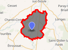
| |
 Bayet  Bayet | |
| Coordinates: 46°14′57″N 3°16′10″E | |
| Country | France |
| Region | Auvergne-Rhône-Alpes |
| Department | Allier |
| Arrondissement | Moulins |
| Canton | Saint-Pourçain-sur-Sioule |
| Intercommunality | Pays Saint-Pourcinois |
| Government | |
| • Mayor (2014–2020) | Bernard Daniel |
| Area 1 | 22.58 km2 (8.72 sq mi) |
| Population (2017-01-01)[1] | 698 |
| • Density | 31/km2 (80/sq mi) |
| Time zone | UTC+01:00 (CET) |
| • Summer (DST) | UTC+02:00 (CEST) |
| INSEE/Postal code | 03018 /03500 |
| Elevation | 237–290 m (778–951 ft) (avg. 235 m or 771 ft) |
| 1 French Land Register data, which excludes lakes, ponds, glaciers > 1 km2 (0.386 sq mi or 247 acres) and river estuaries. | |
The inhabitants of the commune are known as Bayétois or Bayétoises.[3]
Geography
Bayet is located some 36 km (22 mi) south of Moulins[4] and 18 km (11 mi) north-west of Vichy.[5] Access to the commune is by the D2009 (former N9) road from Saint-Pourçain-sur-Sioule in the north which passes through the commune east of the village and continues south to Le Mayet-d'École. The D6 branches off the D2009 in the commune and goes south-east to Saint-Didier-la-Forêt. Access to the village is by the D406 which branches off the D2009 in the commune and goes south-west to the village changing to the D519. The D183 goes south from the village to Barberier. The D219 comes from Chareil-Cintrat in the west and passes through the village before continuing east to join the D6. The D35 from Étroussat in the south-west to Saint-Pourcain-sur-Sioule passes through the west of the commune. Apart from the village there are the hamlets of Nerignet, Le Marais, Les Echaloux, La Rue du Jo, Le Plaix, Le Chambon, and Les Bouillots. The commune is almost entirely farmland.[6][7]
The railway line from La Ferté-Hauterive to Gannat once passed through the commune. It was the last line to have been commissioned by the Chemins de fer de Paris à Lyon et à la Méditerranée in 1932. It was closed to passenger traffic in 1938. The section between the stations of Saint-Pourçain-sur-Sioule and Bayet was closed to freight traffic in 1960 and decommissioned in 1969 followed by a path being created in 1974.[8]
Bayet once had a station on this line. The passenger station was built "midway between the ends of the line, [...] comprising [...] a siding of 700 m length".[9]
The Sioule river flows through the commune from south to north and continues north to join the Allier north-east of Contigny. The Bouble river flows from the west and through the western part of the commune as it flows north-east to join the Sioule on the commune border.[6][7]
Neighbouring communes and villages[6] | |
|---|---|
History
The former commune of Martilly was merged with Bayet in 1807.
Administration
| From | To | Name | Party | Position |
|---|---|---|---|---|
| 2001 | 2020 | Bernard Daniel |
(Not all data is known)
Demography
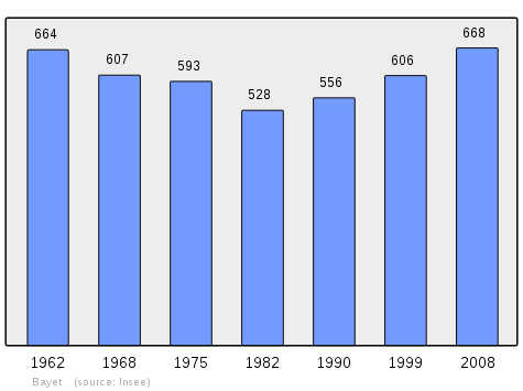
In 2013 the commune had 694 inhabitants.[13] The evolution of the number of inhabitants is known from the population censuses conducted in the commune since 1793. From the 21st century, a census of communes with fewer than 10,000 inhabitants is held every five years, unlike larger communes that have a sample survey every year.[Note 1]
Distribution of Age Groups
Percentage Distribution of Age Groups in Bayet and Allier Department in 2010
| Bayet | Bayet | Allier | Allier | |
|---|---|---|---|---|
| Age Range | Men | Women | Men | Women |
| 0 to 14 Years | 22.6 | 23.2 | 16.8 | 14.7 |
| 15 to 29 Years | 16.1 | 11.9 | 15.4 | 13.6 |
| 30 to 44 Years | 22.6 | 25.9 | 18.5 | 17.2 |
| 45 to 59 Years | 19.9 | 17.7 | 21.9 | 20.9 |
| 60 to 74 Years | 12.3 | 13.7 | 17.2 | 17.8 |
| 75 to 89 Years | 6.5 | 7.6 | 9.5 | 14.1 |
| 90 Years+ | 0.0 | 0.0 | 0.6 | 1.7 |
Sources:
Education
The commune has a primary school which is part of the Académie de Clermont-Ferrand.[15]
Economy
Population and income tax
In 2011, the median household income tax amounted to €26,288, placing Bayet at the 22,612nd ranking of communes with more than 49 households in metropolitan France.[16]
Local taxes applicable in Bayet are: housing tax 8.18%; property tax on built-up properties 8.44%, and Undeveloped properties 33.84%. These rates are unchanged compared in 2014[17] and in 2013 these figures were lower than the average of the stratum corresponding to communes from 500 to 2000 inhabitants. The community of communes to which Bayet belongs is not eligible for the property tax on buildings however the residential tax rate (10.89%) and the developed property (additional charge: 37.57%) exceed those of the commune.[18]
Employment
In 2012 the population aged 15–64 years was 430 people among which 77% were employable, 66.1% in employment and 10.8% were unemployed.[a 1]
There were 446 jobs in the employment area. The number of active employed residing in the area being 287, the job concentration indicator is 155.5% which means that the commune offers more than one job per employable person.[a 2]
Businesses
On 1 January 2013 Bayet had 31 businesses: 10 in industry, 5 in construction, and 16 in trade, transport and other services. There were no businesses in the administrative sector.[a 3]
Industry
The commune has a Combined cycle gas electricity generator, the 3CB (for Central Combined Cycle Bayet), owned by the Swiss energy company Alpiq. It entered service in 2011 with a capacity of 408 megawatts. It produces annually an average of about 1.6 billion kWh, which is equivalent to the consumption of 400,000 homes.[19] 3CB cost 300 million euros.[20] The installation in Bayet was due to the presence of a major high-voltage RTE substation and a GRTgas pipeline.
The Lucane energy plant, established since 1 April 1982, can "enhance the autonomy of municipal waste for 96000 Bourbonnais". This unit is on track to pass ISO 50001 certification.[21][22]
Culture and heritage
Religious heritage
- The Church of Saint Marcel (12th century)

See also
Notes and references
Notes
- At the beginning of the 21st century, the methods of identification have been modified by Law No. 2002-276 of 27 February 2002, the so-called "law of local democracy" and in particular Title V "census operations" allows, after a transitional period running from 2004 to 2008, the annual publication of the legal population of the different French administrative districts. For communes with a population greater than 10,000 inhabitants, a sample survey is conducted annually and the entire territory of these communes is taken into account at the end of the period of five years. The first "legal population" after 1999 under this new law came into force on 1 January 2009 and was based on the census of 2006.
References
- "Populations légales 2017". INSEE. Retrieved 6 January 2020.
- Bayet on Lion1906
- "Bayet (03500)". habitants.fr (in French). SARL Patagos. Retrieved 24 January 2016.
- "Orthodromie entre Bayet et Moulins" [Orthodromy between Bayet and Moulins]. Lion 1906 (in French). Retrieved 24 January 2016.
- "Orthodromie entre Bayet et Vichy" [Orthodromy between Bayet and Vichy]. Lion 1906 (in French). Retrieved 24 January 2016.
- Bayet on Google Maps
- Bayet on the Géoportail from National Geographic Institute (IGN) website (in French)
- Line from La Ferté-Hauterive to Gannat (in French). Retrieved on 4 July 2015.
- "Bulletin PLM n°23 de septembre 1932: Ouverture de la ligne de La Ferté-Hauterive à Gannat" [Bulletin PLM No. 32 of September 1932: Opening of the line from La Ferté-Hauterive to Gannat]. WikiPLM (in French). Retrieved 4 July 2015.
- Bayet on the 1750 Cassini Map
- Bayet on the 1790 Cassini Map
- List of Mayors of France (in French)
- "2013 legal populations: Bayet". INSEE (in French). Retrieved 24 January 2016.
- [Template:Database Population Bayet, Allier Census of population on 1 January 2006] on the site of Insee.
- "Schools in Bayet". French Ministry of National Education (in French).
- Page RFDM2011COM: Revenus fiscaux localisés des ménages - Year 2011, Insee (20MB) (in French).
- The Municipal Council has voted on its budget, La Montagne, 21 April 2015, 18 pages, Vichy (in French)
- The accounts of communes and their groupings: individual data (from 2000 to 2013) Archived 2015-07-04 at the Wayback Machine, consulted on 25 July 2015 (click on 03 Allier > B > BAYET) (in French)
- "3CB : The Central Combined cycle of Bayet" (PDF). Alpiq.fr (in French). Retrieved 25 July 2015.
- Ména, Stéphanie; Bigard, Philippe (12 November 2013). "A semi-central nuclear reactor". La Montagne (in French).
- "The Lucane works has blown its 33 candles". La Montagne (in French). Vichy. 3 April 2015. p. 19.
- "The Lucane UVE of Bayet 33 year anniversary". Veolia.fr (in French). 30 March 2015. Retrieved 25 July 2015.
- Ministry of Culture, Mérimée PA00092984 Church of Saint Marcel

INSEE References
- Commune of Bayet (03018) - Complete File, consulted on 4 July 2015 (in French):
- EMP T1 – Population from 15 to 64 years by type of activity.
- EMP T5 – Employment and Activity (in French)
- DEN T3 – Number of enterprises by sector of activity at 1 January 2013 (in French)
- TOU T1 – Number and capacity of hotels on 1 January 2015 (in French)
- TOU T2 – Number and capacity of camp sites on 1 January 2015 (in French)
- TOU T3 – Number of other collective accommodations on 1 January 2015 (in French)
| Wikimedia Commons has media related to Bayet. |