Estivareilles, Allier
Estivareilles is a commune in the Allier department in central France. It lies about 10 km north of Montluçon on the right-hand side of the Cher river. There is a Lavoir (a public washing basin), a lantern of the dead and a church from the nineteenth century.
Estivareilles | |
|---|---|
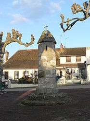 Lantern of the dead | |
Location of Estivareilles 
| |
 Estivareilles  Estivareilles | |
| Coordinates: 46°25′34″N 2°37′10″E | |
| Country | France |
| Region | Auvergne-Rhône-Alpes |
| Department | Allier |
| Arrondissement | Montluçon |
| Canton | Huriel |
| Intercommunality | Val de Cher |
| Government | |
| • Mayor (2014–2020) | Georges Pailleret[1] |
| Area 1 | 11.27 km2 (4.35 sq mi) |
| Population (2017-01-01)[2] | 1,103 |
| • Density | 98/km2 (250/sq mi) |
| Time zone | UTC+01:00 (CET) |
| • Summer (DST) | UTC+02:00 (CEST) |
| INSEE/Postal code | 03111 /03190 |
| Elevation | 179–348 m (587–1,142 ft) (avg. 230 m or 750 ft) |
| 1 French Land Register data, which excludes lakes, ponds, glaciers > 1 km2 (0.386 sq mi or 247 acres) and river estuaries. | |
Population
| Historical population | ||
|---|---|---|
| Year | Pop. | ±% |
| 1962 | 728 | — |
| 1968 | 863 | +18.5% |
| 1975 | 939 | +8.8% |
| 1982 | 1,101 | +17.3% |
| 1990 | 1,104 | +0.3% |
| 1999 | 1,033 | −6.4% |
| 2008 | 1,046 | +1.3% |
| 2009 | 1,085 | +3.7% |
| 2012 | 1,127 | +3.9% |
| Source: INSEE | ||
See also
References
- "Liste nominative des communes de l'Allier (avec maire, arrondissement et canton)" [Nominative list of communes of Allier (with mayor, arrondissement and canton)] (PDF). Association of Mayors and Presidents of Communities of Allier (in French). 1 April 2015. Archived from the original (PDF) on 18 May 2015. Retrieved 1 August 2015.
- "Populations légales 2017". INSEE. Retrieved 6 January 2020.
External links
- The official web site of the mayor of Estivareilles
- Estivareilles page at the National Geographical Institute (archived)
| Wikimedia Commons has media related to Estivareilles, Allier. |
This article is issued from Wikipedia. The text is licensed under Creative Commons - Attribution - Sharealike. Additional terms may apply for the media files.