Saint-Bonnet-de-Four
Saint-Bonnet-de-Four is a commune in the Allier department in Auvergne-Rhône-Alpes in central France.
Saint-Bonnet-de-Four | |
|---|---|
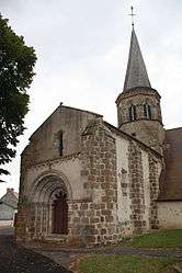 The church in Saint-Bonnet-de-Four | |
Location of Saint-Bonnet-de-Four 
| |
 Saint-Bonnet-de-Four  Saint-Bonnet-de-Four | |
| Coordinates: 46°18′49″N 2°54′40″E | |
| Country | France |
| Region | Auvergne-Rhône-Alpes |
| Department | Allier |
| Arrondissement | Montluçon |
| Canton | Commentry |
| Intercommunality | Commentry Montmarault Néris Communauté |
| Government | |
| • Mayor (2020–2026) | Daniel Beaulaton[1] |
| Area 1 | 18.73 km2 (7.23 sq mi) |
| Population (2017-01-01)[2] | 212 |
| • Density | 11/km2 (29/sq mi) |
| Time zone | UTC+01:00 (CET) |
| • Summer (DST) | UTC+02:00 (CEST) |
| INSEE/Postal code | 03219 /03390 |
| Elevation | 318–476 m (1,043–1,562 ft) (avg. 467 m or 1,532 ft) |
| 1 French Land Register data, which excludes lakes, ponds, glaciers > 1 km2 (0.386 sq mi or 247 acres) and river estuaries. | |
Population
| Historical population | ||
|---|---|---|
| Year | Pop. | ±% |
| 1962 | 269 | — |
| 1968 | 299 | +11.2% |
| 1975 | 259 | −13.4% |
| 1982 | 228 | −12.0% |
| 1990 | 227 | −0.4% |
| 1999 | 221 | −2.6% |
| 2008 | 200 | −9.5% |
| 2013 | 208 | +4.0% |
| Source: INSEE (1968–2013) | ||
Sights
- Church of Saint Bonnet, with its bent steeple and ornate doors.
The original church dates from the 11th century and is a designated historic monument. In the 14th century, a Gothic chapel was added on the right of the transept.
The steeple was struck by lightning in 1894 and rebuilt from green wood that subsequently warped and became a local curiosity. In 1978, when the church was restored, the requirement that it be rebuilt exactly like the original meant that the 1/8 turn in the steeple had to be maintained.
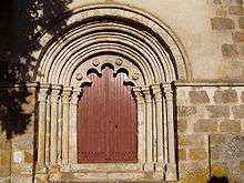
Door of the church
See also
References
- INSEE commune file (in French)
- "Daniel Beaulaton nouveau maire de Saint-Bonnet-de-Four (Allier)" [Daniel Beaulaton new mayor of Saint-Bonnet-de-Four, Allier]. La Montagne (in French). 4 June 2020. Retrieved 4 June 2020.
- "Populations légales 2017". INSEE. Retrieved 6 January 2020.
| Wikimedia Commons has media related to Saint-Bonnet-de-Four. |
This article is issued from Wikipedia. The text is licensed under Creative Commons - Attribution - Sharealike. Additional terms may apply for the media files.