Barwani
Barwani is a town and a municipality in Barwani district in the state of Madhya Pradesh, India. The town is situated near the left bank of the Narmada River, and is the administrative headquarters of Barwani District. It has served as the capital of the former princely state of Barwani. It can be reached by road only. Bawangaja, a Jain pilgrimage place, is 8 km from Barwani.
Barwani | |
|---|---|
| Nickname(s): | |
 Barwani  Barwani | |
| Coordinates: 22.03°N 74.9°E | |
| Country | |
| State | Madhya Pradesh |
| Region | Nimar |
| District | Barwani district |
| Government | |
| • Type | Municipal council |
| • Body | Municipal Council of Barwani |
| • Chairperson | Lakshman Singh Chauhan (INC) |
| Area | |
| • Total | 27 km2 (10 sq mi) |
| Elevation | 178 m (584 ft) |
| Population (2011) | |
| • Total | 55,504 |
| • Density | 2,100/km2 (5,300/sq mi) |
| Demonym(s) | Nimadi |
| Languages | |
| • Official |
|
| • Regional |
|
| Time zone | UTC+5:30 (IST) |
| PIN | 451551 |
| Telephone code | 07290 |
| Vehicle registration | MP-46 |
| Website | barwani |
Origin of name
The name Badwani originated from the forests of BAD which had surrounded the city in old times. WANI is the old word for the Garden. Hence city got its name BADWANI which means Garden of Bads. Barwani is still pronounced as Badwani but it spells Barwani.
Geography
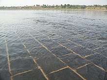
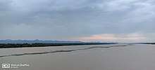
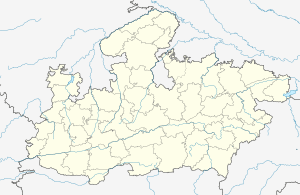
Barwani is located at 22.03°N 74.9°E.[1] It has an average elevation of 178 metres (583 feet). The great Narmada River flows through Barwani (5 km from city center). The maximum temperature of Barwani in April and May used to go as high as 48'C, making it one of the hottest place in Central India. However, in recent years, it has cooled a little bit.
Barwani is surrounded by the great hills of Satpura and in the raining days it becomes one of the most beautiful places in central India. The city is also called the Paris of Nimar. Nimar region is split into East Nimar and West Nimar. Nimar, in local terms, means "area beyond Neem Trees". Barwani lies in West Nimar. The annual rainfall of Barwani is around 15 inches, though since 2006, it has increased a lot. Barwani is famous for its Papitas (Papayas) and Bawangaja (a Jain holy place 8 km from Barwani).
Transportation infrastructure
Barwani has good connectivity via roads.
Railways[2]
Barwani has no direct railway connectivity. The Western Railway (Ratlam Mandal) has a reservation counter in Barwani (Ambedker Park on Rajghat Road). The nearest railway station is situated at Indore. Another nearer railway station is Khandwa on the Central Railway, which is 180 km from Barwani via State highway No 26.
Roads
Barwani is well connected to other parts of Madhya Pradesh and India with national and state highways. The city is connected to the Agra-Bombay national highway no.3 by Khandwa-Baroda interstate highway no.26 at the distance of 51 km at Thikri . There are bus services to and from all of the major and minor cities near Barwani, including Indore, Khandwa, Ujjain, Dewas, Dhar, Ratlam, Khargone, Harda, Mumbai, Ahmedabad, and Vadodara.
Demographics
As of 2011 India census,[2] Barwani had a population of 55,504. Males with a population of 28,437 constitute 51% of the population and females with a count of 27,067, constitute 49%.
Population of Children with age of 0-6 is 6961 which is 12.54% of total population of Barwani. In Barwani Municipality, Female Sex Ratio is of 952 against state average of 931. Moreover, Child Sex Ratio in Barwani is around 919 compared to Madhya Pradesh state average of 918. Literacy rate of Barwani city is 82.10% higher than state average of 69.32%. In Barwani, Male literacy is around 87.17% while female literacy rate is 76.80%.
Schedule Tribe (ST) constitutes 23.29% while Schedule Caste (SC) were 9.95% of total population in Barwani.[3]
Out of total population, 18,438 were engaged in work or business activity. Of this 13,957 were males while 4,481 were females. In census survey, worker is defined as person who does business, job, service, and cultivator and labour activity. Of total 18438 working population, 89.06% were engaged in Main Work while 10.94% of total workers were engaged in Marginal Work.[3]
Economy
Economically Barwani is entirely dependent on agriculture, with several other small industries developing in the area. Following is a list of national banks operating in Barwani.
Culture
Main festivals
All major festivals Holi, Raksha Bandhan, Ganesh Utsav, Navratri, Dussehra, Deepavali, Muharram, Gudi Padwa, gangore, Bhaidooj, Eid, Christmas, Nagpanchmi are celebrated with equal enthusiasm. Barwani is famous for jhakis (झाकी) during Ganesh Utsav and Tajiye during the Muharram. it is the major village of festivel, people of Barwani are so religious that they enjoy each and every festival with same level of energy.
Temples
- Ganesh Mandir (Jambu Gali)
- Shree Sanwariya Mandir
- Vaishno Devi Mandir
- Hanuman Mandir (Near Segaon)
- Kalika Mata Mandir
- Mahalaxmi Mandir
- Santoshi Mata Mandir
- Ram-Krishna Mandir
- Moti Mata Mandir
- Shani and Sai Mandir
- Satyanarayan Mandir
- Gayatri Mandir
- Shri Siddhanath Mahadev Mandir
- Ramkulleshwar Mandir
- Shani Mandir
- Bhilat Mandir
- Sawaria Seth Mandir
- Hanuman Mandir Segaon Tekri
- Hanuman mandir nawal pura
- Bhilat baba mandir choti kasarawad road
Entertainment
Cinema Halls
- Mahendra
- Laxmi
Places of interest
- Bawangaja (Jain Mandir)
- Bandhan (Water Fall)
- Rajghat (Narmada River)
- Gwalbeda (Jain Mandir)
- Dhobdiya Talab (DRP Line)
Health care
Barwani is prominent in Nimar and Malwa regions for its health care facilities with its district hospital and many other private hospitals.
- Barwani District Hospital
- Mahamartunjaya Hospital
- Asha Gram Trust
- Saraswati Eye Hospital
- Samraddhi Child Care Hospital
- Sai Hospital
- New Sai Baba Healthcare Hospital
- GMH
- New Sai Hospital
Barwani District Hospital is one of the oldest hospitals in Madhya Pradesh.
Education
Colleges
- Balaji Institute of Technology, Kerwa(Thikri)
- Govt. Polytechnic College, Barwani
- Nimar Institute of IT Barwani
- Aadinath Institute of Information Technology & Management, Barwani
- S.B.N. Government P.G. College, Barwani
- Government Girls College, Barwani
- Career Institute
- Narmada institute Barwani
- Rajkumar Khandelwal Institute of Information Technology, Barwani
Schools
- Divya Sanskar Academy, Barwani
- J.M.S. school Barwani
- Bal Jagat Higher Secondary School Barwani
- Kendriya Vidyalaya Barwani
- GURUKUL PUBLIC SCHOOL BARWANI (English Medium)
- E.M.R.S. BARWANI
- Panjataniyah English Medium Higher Secondary School
- Career School Of Sanskar English Medium (Career group) Barwani
- Vaishnavi Vidya Vihar Higher Secondary School
- Paramount Academy barawani (CBSE)
- Harsukh Digamber Jain Higher Secondary School
- School of Excellence (Higher secondary)
- Gov. Boys Higher Secondary School No.2
- Gov. Girls Higher Secondary School
- Saraswati Shishu/vidhya Mandir
- Rotary Higher Secondary School
- Barwani Public School
- St. Mary's High Secondary School
- St. Joseph's Higher Secondary School
- Knowledge-Rain High school
- Puspkunj Vidhya Mandir
- Rajkumar Khendalwal Memorial Higher Secondary school
- Saket International School Barwani road Anjad
- K.V. Barwani [central school]
- Gov.boys Middle School
- Crescent Public School
- Gov.Boys High School
- Narmada convent higher secondary school
- Gov.Girls College Barwani
- mahatma gandhi memo high school barwani
Gallery
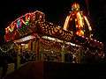 Vaishno Devi Mandir during festival, Barwani
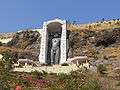 84 feet tall, huge statue of Bhagwan Rishabhadeva at Bawangaja
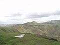 Beauty of Satpura Hills
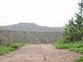 Beautiful Satpura Hills, Barwani
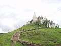
 Choolgiri View from forest point
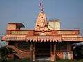 MAA VAISHNO DEVI MANDIR
 Mandar Bakery Barwani Navratri 2012
Notable Persons
- Dr.Anil Kakodkar, India's eminent nuclear physicist, and former chairman of the Atomic Energy Commission of India and the Secretary to the Government of India, Department of Atomic Energy was born in Barwani.
References
- Falling Rain Genomics, Inc - Barwani
- "Census of India 2011: Data from the 2011 Census, including cities, villages and towns (Provisional)". Census Commission of India. Retrieved 18 June 2015.
- http://www.census2011.co.in/data/town/802285-barwani-madhya-pradesh.html