Ratlam
Ratlam ![]()
Ratlam | |
|---|---|
City | |
 | |
 Ratlam  Ratlam  Ratlam | |
| Coordinates: 23.334°N 75.037°E | |
| Country | India |
| State | Madhya Pradesh |
| Region | Malwa |
| District | Ratlam |
| Government | |
| • Body | Ratlam municipal corporation |
| Area | |
| • Total | 50 km2 (20 sq mi) |
| Elevation | 480 m (1,570 ft) |
| Population (2011)[1] | |
| • Total | 264,914 |
| • Rank | 9th in Madhya Pradesh |
| • Density | 5,300/km2 (14,000/sq mi) |
| Demonym(s) | Ratlami |
| Language | |
| • Official | Hindi[2] |
| Time zone | UTC+5:30 (IST) |
| PIN | 457001 |
| Telephone code | 07412 |
| Vehicle registration | MP-43 |
| Climate | Humid subtropical climate (Köppen) |
| Precipitation | 937 millimetres (36.9 in) |
| Avg. annual temperature | 24 °C (75 °F) |
| Avg. summer temperature | 28 °C (82 °F) |
| Avg. winter temperature | 16 °C (61 °F) |
| Website | www |
In 2019 Guman Singh Domar of Bharatiya Janata Party had been elected as the Member of Parliament from Ratlam.[4]
Early history

Ratlam State was founded in 1652 by a great-grandson of Raja Udai Singh of Jodhpur, namely Raja Ratan Singhji, son of Mahesh Das of Jalor. The latter, father, and son, had performed important military services for the Emperor Shah Jahan by defeating the Persians and Uzbeks in Afghanistan. In reward for their services and in recognition of their great deeds of valour, large territories in the south-western districts of Rajputana and northern Malwa were conferred on them. Their capital became Rattram named after Raj Ratan Singh and his first son Ram Singh as "Ratram", which later got translated to Ratlam.
Maharaja Ratan Singh 1652/1658, courageous in youth, he gained Padshah Shah Jahans notice by calming the Emperors favourite elephant which had run amok in the Agra Palace Garden, fought for the Emperor against the Persians in Kabul and Qandahar, later in 1652, the Emperor substituted Jalore for the pargana of Ratlam and many other areas, and he became the first Raja of Ratlam, in 1658 a false rumour of the death of the Emperor resulted in a frenzied scramble for succession to the throne amongst his sons. Dara Shikoh who was officiating for his father, sent a combined army of Rajputs and Muslims under the command of Maharaja Jaswant Singh of Jodhpur, against his brother Aurangzeb. The Maharaja, as head of the Rathore clan, was persuaded to hand over command of the Imperial army to Maharaja Ratan Singh. Non-co-operation by the Muslim commanders resulted in the army sustaining heavy losses in the fierce battle at Dharmat, as well as the death of Ratan Singh (said to have sustained 80 sword wounds on his body), he married (amongst others), Maharani Sukhroopde Kanwar Shekhawat Ji Sahiba, daughter of Kunwar Purshottam Das of Jhajhar [Shekhawati], and had issue. He died in 1658 in battle at Dharmat near Ujjain.
Commercial history

Ratlam was one of the first commercial cities established in Central India. The city quickly became known for trading in opium, tobacco, and salt, as well as for its bargains called "Sattas". Before the opening of the Rajputana State Railway to Khandwa in 1872, there was no better place to trade than in Ratlam.
The city is known for its love of food, its taste particularly the world popular salty snack 'Ratlami Sev'. The purity of Gold Jewellery and Saree Market of Ratlam outshines in India.
Princely history
Ratlam was part of the Malwa Agency of Central India during the British Raj. The state's capital was Ratlam town in modern Ratlam district of Madhya Pradesh. Ratlam was originally a huge state, but the then ruler Ratan Singh opposed Aurangzeb in the Battle of Dharmatpur and was killed after a brave fight. The state was then reduced and the title of Maharaja has eventually stripped away; the title was later restored by the British during Maharaja Sajjan Singh's rule. On 5 January 1819 Ratlam State became a British protectorate
The state had an area of 902 sq mi, which was closely interlaced with the territories of the princely state of Sailana. In 1901, Ratlam State had a population of 83,773,[5] with the city population of 36,321. The state had an estimated revenue of £34,000 and paid a £2,850 tribute.
Geography
Ratlam is located at coordinates: 23°19′0″N 75°04′0″E (23.316667, 75.066667). The city has an area of 22.0 square miles (50.0 km²). It is very close to the borders of Rajasthan and Gujarat.
Climate
Ratlam, like most of Madhya Pradesh, has humid subtropical climate (Cfa) zone. Three distinct seasons are observed: summer, monsoon and winter. Summers start in mid-March and can be extremely hot from April through June. Highs can reach 112 °F (44 °C), although the humidity is extremely low. The monsoon season starts in late June, with temperatures averaging around 100 °F (38 °C), with sustained, torrential rainfall and high humidity. The average rain fall is 37 inches (937 mm). Winters start in mid-November and are dry, cool and sunny. Temperatures average about 39–46 °F (4–8 °C), but can fall close to freezing on some nights.[6] Ratlam gets moderate rainfall of 35 to 38 inches (890 to 970 mm) from July through September, due to the southwest monsoon.
| Climate data for Ratlam, India (December 2010 - December 2011) | |||||||||||||
|---|---|---|---|---|---|---|---|---|---|---|---|---|---|
| Month | Jan | Feb | Mar | Apr | May | Jun | Jul | Aug | Sep | Oct | Nov | Dec | Year |
| Record high °F (°C) | 91 (33) |
97 (36) |
103 (39) |
112 (44) |
112 (44) |
111 (44) |
100 (38) |
97 (36) |
102 (39) |
104 (40) |
99 (37) |
91 (33) |
112 (44) |
| Average high °F (°C) | 75 (24) |
82 (28) |
91 (33) |
99 (37) |
101 (38) |
93 (34) |
84 (29) |
81 (27) |
86 (30) |
88 (31) |
83 (28) |
78 (26) |
87 (31) |
| Average low °F (°C) | 42 (6) |
48 (9) |
60 (16) |
68 (20) |
74 (23) |
77 (25) |
74 (23) |
72 (22) |
71 (22) |
67 (19) |
52 (11) |
45 (7) |
63 (17) |
| Record low °F (°C) | 32 (0) |
33 (1) |
45 (7) |
48 (9) |
59 (15) |
59 (15) |
52 (11) |
52 (11) |
55 (13) |
50 (10) |
39 (4) |
33 (1) |
32 (0) |
| Average precipitation inches (mm) | 0.3 (7.6) |
0.1 (2.5) |
0.1 (2.5) |
0.1 (2.5) |
0.6 (15) |
5.4 (140) |
11.7 (300) |
12.2 (310) |
7.3 (190) |
1.4 (36) |
0.7 (18) |
0.3 (7.6) |
36.2 (920) |
| Source: Weatherbase.com[6] | |||||||||||||
Demographics
According to the 2011 Census, the city of Ratlam has a population of 264,914 of which 134,915 are male and 129,999 are female. The sex ratio is 964 females to 1000 males. Children between the 0 to 6 years of age constitute 29,763 individuals. The total number of literates in Ratlam was 204,101, which constituted 77.0% of the population with male literacy of 81.2% and female literacy of 72.8%. The effective literacy rate of 7+ population of Ratlam was 86.8%, of which male literacy rate was 91.7% and female literacy rate was 81.8%. The Scheduled Castes and Scheduled Tribes population was 27,124 and 12,567 respectively. The total number of households in Ratlam is 53133.[1]
Transportation
Railways
.jpg)
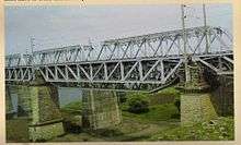
Ratlam Junction is a major junction on Delhi-Mumbai and Ajmer-Khandwa Rail routes and rail division of Indian Railways on broad gauge lines on Western Railways Zone. Ratlam junction is Divisional headquarters of Western Railway Zone.[7] There are four major railway tracks passing through Ratlam City, leading to Mumbai, Delhi, Ajmer and Khandwa. It is one of the major Railway Junction of Western Railways. Ratlam Junction experiences halt of around 157 trains on a daily basis. All the major superfast trains like Rajdhani, Garib Rath have their staff changing stoppage at Ratlam Junction.
Ratlam is also the first ever clean train station of Indian Railways network. Under this scheme, Indian Railways has introduced cleaning of coaches of a train en route while it halts at a particular station for 15 to 20 minutes. The entire train is cleaned with vacuum cleaners and toilets are washed with handheld portable HP cleaners.[8]
Ratlam station is believed to be one of the busiest railway stations in India.[9]
Ratlam Junction is referred in 2007 Hindi romantic comedy film Jab We Met.[10] though the shooting had not happened actually in Ratlam and the places and locations mentioned in the film don’t exist in the city.
Roads
Ratlam is connected to Indore and Neemuch via National Highway 79. This four-lane highway runs from Indore to Chittorgarh to join the Golden Quadrilateral.
The city has regular bus services to Udaipur, Banswara, Mandsaur, Neemuch, Indore, Bhopal, Dhar, Ujjain, Petlawad, Jhabua, etc. Ratlam almost halfway points on Mumbai Delhi Highway
Ratlam has local city transport in the form of Auto Rickshaws, Tata Magic and coming up city buses.
Airport
The city does not have any airport but has an airstrip on Banjali. The nearest airport is Devi Ahilya Bai Holkar Airport at Indore (137 km), Raja Bhoj Airport at Bhopal (289 km), Maharana Pratap Airport at Udaipur (252 km), Sardar Vallabhbhai Patel International Airport at Ahmedabad (340 km).
Economy
Business
Ratlam has several industries which manufacture copper wire, plastic ropes, chemicals and artificial oxygen, among other products. Ratlam is also very well known for Gold, Ratlami Sev, Ratlami Saari and handicrafts.
Agriculture
The major crops grown in the district include Soybean, Wheat, Maize, Gram, Cotton, Garlic, Onion, Peas, Guava, Pomegranate, Grapes & Opium in the region of Jaora Tehsil of Ratlam.
Jain Temple
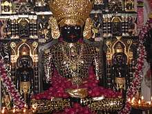
Shri Nageshwar Parshwanath Tirth
This Temple is a Shwetambar Jain Temple dedicated to Parshvanatha, the 23rd tirthankar of Jainism. This temple is situated at the junction line of the border of Madhya Pradesh and Rajasthan State. This temple is considered very miraculous. Moolnayak of this temple is a green colored Parshwanath with hood of 7 cobras. This 13½ feet idol is carved from a single emerald stone. The idol is around 2850 years old. It is believed that this statue was crafted by Dharnendra. Near the Lord's idol, there are also other idols of Lord Shri Shantinath Swami & Lord Shri Mahavir Swami. On the wall, behind the 7 faces of the snake that is spread over the idol's head as a shelter, is a hole which houses a snake, The snake is rarely seen coming out from its hole. A lucky person can only have a glimpse of it. It is either seen in black or white color.[11]
Bibrod Tirth
Bibrod Tirth is a 13th-century Temple. This temple is dedicated to Adinath, the 1st tirthankar of Jainism. Moolnayak is a 2.5 ft black-colored idol of Bhagawan Adinath in the Padmasana posture. The inscription on his idol belongs to a period earlier than even the thirteenth century.This tirth is also famous for its annual fair which is popularly known as "Bibrod Mela".
Hindu Temple
Kalka Mata Temple
This temple well-known hindu temple and gathering place with popular gardens and nearby street food vendors. This temple is established by the royal family. The temple has a pond which is called jhali talab in the name of a queen. Behind the temple,14 ram-bag and government offices and dist. court. In the ram-bag 14 lives Kamdar Bekhala Shrestha, who came from Nepal and Kamdar of Royal Family of Ratlam since 1947. He came from Nepal. late queen smt. Prabharajaya Laxmi is from nepal and Kandar Bekhalal came with her. Pashupati, Narendra, Bhupandra, Gajandra are family member. There are big gardens here.
References
- "Ratlam - Census 2011". censusindia.gov.in. Retrieved 13 February 2020.
- "52nd REPORT OF THE COMMISSIONER FOR LINGUISTIC MINORITIES IN INDIA" (PDF). nclm.nic.in. Ministry of Minority Affairs. Archived from the original (PDF) on 25 May 2017. Retrieved 7 June 2019.
- Ratlam District Information, ratlam.nic.in. Retrieved 15 March 2012.
- "Ratlam Election Results 2019 Live Updates (Jhabua ): Guman Singh Domar of BJP Wins". News18. Retrieved 23 May 2019.
- "Archived copy". Archived from the original on 12 November 2013. Retrieved 12 November 2013.CS1 maint: archived copy as title (link)
- Indore, India Weather (closest to Ratlam), weatherbase.com, 15 March 2012.
- Ratlam Junction http://ratlam.nic.in/profile.html#TRANSPORT
- Clean Train Station http://relyoncts.com/service-location-ratlam.php
- Western Railway - Ratlam, indianrailways.gov. Retrieved 16 March 2012.
- Jab We Met
- http://nageshwartirth.org/about_the_temple_idol.php