Bạch Long Vĩ Island
Bạch Long Vĩ island is located in the Gulf of Tonkin, about halfway between Haiphong (Vietnam) and Hainan Island (China). The island is an offshore district of Haiphong city. Fishing comprises the majority of economic activity in the Gulf of Tonkin, and Bạch Long Vĩ is a major nursery and harvesting area for fish eggs. More than 50 species of commercial fish are abundant in the area (ADB 1999).
| Nickname: Phù Thủy Châu | |
|---|---|
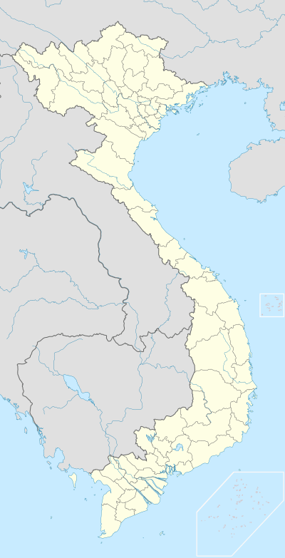 Bạch Long Vĩ Location in Vietnam | |
| Geography | |
| Location | Between Haiphong (Vietnam) and Hainan Island (China) |
| Coordinates | 20°08′00″N 107°43′40″E |
| Area | 3.045 km2 (1.176 sq mi) |
| Administration | |
Vietnam | |
| City | Haiphong |
| County | Huyện Bạch Long Vĩ |
| Demographics | |
| Population | 912 (2018) |
| Pop. density | 297/km2 (769/sq mi) |
| Ethnic groups | Kinh people |
Name
In Vietnamese, "Bạch Long Vĩ" (Chinese: 白龍尾) means "The Tail of the White Dragon". Before the 20th century, the island used to be called "Vô Thủy" which means "no water" since there was no water source on the island.
According to Li Dechao, before the 1950s, Nightingale Island (Yeying Is.; Chinese: 夜鶯島; Pinyin: Yèyīng Dǎo) is the former toponym of Bạch Long Vĩ Island.[1][2] Fushui Isle (Chinese: 浮水洲; Pinyin: Fúshǔi Zhōu; Vietnamese: "Phù Thủy Châu" meaning "pearl floating on water") is the name used among both Danzhou Hainan Chinese and Vietnamese fishermen.[2]
Geography
Bạch Long Vĩ sits 58 meters above sea level, and is a plateau. There are no other significant exposed land masses within 75 km of the island.
On the tectonic-structure framework, Bạch Long Vĩ island is located on a local uplifted block in a northeast–southwest direction belonging to the northwest flank of the Song Hong Cenozoic sedimentary basin, closed by the east with the basin of the Northern Gulf of Tonkin. The island is composed of sedimentary rocks of sandstone, siltstone and claystone from the Phù Thủy Châu formation the Oligocene with a thickness of about 200 m, and the Hoa Mi formation from the middle Miocene–Pliocene with a thickness about 55 - 60 m.[3]
History
Historically, before the 20th century, Bạch Long Vĩ island was not inhabited due to the lack of water resources.[4]
In 1887, a convention between China (Qing Dynasty) and France made the government cede the island to French Indochina (Annam Protectorate).[5] However, this was not an acceptable result for China. In the contemporary published map of the People's Republic of China and other nations, this island still remained a part of China (Goode's World Atlas, Rand McNally, 1933). Also, some foreign scholars regarded that this island had been China's territory at least up to 1950.[6]
During World War II, the Japanese army forced the French out of Indochina and seized the island in 1945.
In 1949, the Chinese Communist Party won the Chinese Civil War against Chiang Kai-shek's army.
In 1955 the People's Republic of China drove Chiang Kai-shek's army away and seized the island.[4]
On January 16, 1957, China's government transferred the island to North Vietnam's government.[4] On that day, the Prime Minister of Vietnam signed Decree Number 49/Ttg which stipulated that Bạch Long Vĩ island is a “xã” (village) and belongs to Haiphong city. That year a fish farm co-operative (Hợp tác xã Nông ngư), which had 93 workers and 22 hectares of land and 13 ships, was established on the island.[4]
On December 9, 1992, the Vietnamese government signed Decree Number 15/NĐ/CP which stipulated that Bạch Long Vĩ island is a district belonging to Haiphong.
In the convention on the Gulf of Tonkin signed between the Vietnamese and Chinese governments, China respects the Vietnamese sovereignty over the island and there is no dispute over the island.[7]
The core issue to be settled in the Gulf of Tonkin is which principle should be used in order to divide the Gulf. In this context, the impact of islands is of crucial importance and, in particular, the Vietnamese controlled Bach Long Vi Island. The first question is whether or not it qualifies as an island according to the provisions of the 1982 United Nations Law of the Sea Convention (1982 UNCLOS). If it does impact on the tracing of a line of equidistance if this principle is applied in the Gulf of Tonkin. Logically, Vietnam would take the position that Bach Long Vi Island should have its full impact in any agreement on how to divide the Gulf. On the other hand, China has an interest in minimising the impact that the Island would have on any agreed delimitation. This could be done by, either arguing that Bach Long Vi is not an island in accordance with the provisions of 1982 UNCLOS or, by arguing that its impact should be minimised and possibly even be disregarded. For China to argue that it is not an island would be counterproductive as China has earlier controlled the island and has claimed that the island was inhabited before it was handed-over to Vietnam in the late 1950s.
(The Management of the Border Disputes Between China and Vietnam and its Regional Implications by Assoc.Prof.Ramses Amer, Co-ordinator, South-East Asia Program (SEAP), Department of Peace and Conflict Research, Uppsala University, and Senior Research Adviser, Department of Research Co-operation-SAREC, Swedish International Development Co-operation Agency (SIDA), October 2000)
Wildlife and biodiversity
The island is home to several species of migratory birds, including storks, turtle doves, drongos and swamphens. Local Vietnamese authorities have programs in place to protect these birds during their migratory season.
1,490 species of plants and animals have been discovered on and surrounding the island. Of these, there are 367 species of terrestrial plants; 17 species of mangroves; 227 species of marine phytoplankton; 65 species of seaweed; 1 species of seagrass; 110 species of marine zooplankton; 125 benthic species; 94 coral species; 451 species of marine fish; and groups of birds, mammals, amphibians and reptiles totalling 45 species. Bạch Long Vĩ Island and the waters around the island have listed 28 species of rare, threatened and endangered species, including two species of terrestrial plants in the genus Magnolia, 11 species of Coelenterata, 7 molluscan species and 8 species of vertebrate. Marine vertebrates include rorqual whales.[8]
Conservation issues
Due to its distance from the mainland, Bạch Long Vĩ is used as a base for offshore fishing. The marine resources in the immediate vicinity of the island are subject to over-harvesting and destructive fishing practices.[9]
References
- "Historical names of Nightingale Island". Retrieved 2009-02-16.
- Li, Dechao (1996). "Rectification of the name of Pai-lung-wei Is". 海洋世界. 9: 6~7.
- Thiên nhiên và môi trường vùng biển đảo Bạch Long Vĩ - Nature and environment in Bach Long Vi island and sea - ResearchGate Archived March 4, 2016, at the Wayback Machine
- Official history of Bach Long Vi island Archived November 18, 2016, at the Wayback Machine
- "Undelimited maritime boundaries of the Asian Rim in the Pacific Ocean", John Robert Victor Prescott, Shelagh Furness, Clive H. Schofield, International Boundaries Research Unit
- "The Management of the Border Disputes Between China and Vietnam and its Regional Implications by Assoc.Prof.Ramses Amer, Co-ordinator, South-East Asia Program (SEAP), Department of Peace and Conflict Research, Uppsala University, and Senior Research Adviser, Department of Research Co-operation-SAREC, Swedish International Development Co-operation Agency (SIDA), October 2000"
- Hoạch định ranh giới biển giữa VN và TQ (kỳ 1) Archived May 11, 2016, at the Wayback Machine
- Hải Phòng. The - Ngoc Hung. 2013. Cá voi dài 10 mét chết dạt vào đảo Bạch Long Vĩ. Retrieved on Mảch 07, 2017
- Thiên nhiên và môi trường vùng biển đảo Bạch Long Vĩ - Nature and environment in Bach Long Vi island and sea - ResearchGate Archived February 18, 2015, at the Wayback Machine
- Draft coastal and marine protected area plan. Hanoi: Asian Development Bank. (1999)
- Nguyen Chu Hoi, Nguyen Huy Yet and Dang Ngoc Thanh eds. Hai Phong: Hai Phong Institute of Oceanography. In Vietnamese. (1998)
External links
- The South China Sea Island China Gave Away by Zhen Gang Ji
| |||||||||
| |||||||||
Districts of the Red River Delta | ||
|---|---|---|
| Hanoi city |
|  |
| Haiphong city |
| |
| Bắc Ninh Province | ||
| Hà Nam Province | ||
| Hải Dương Province |
| |
| Hưng Yên Province | ||
| Nam Định Province | ||
| Ninh Bình Province | ||
| Thái Bình Province | ||
| Vĩnh Phúc Province |
| |
※ denotes provincial seat. | ||