Nam Từ Liêm District
Nam Từ Liêm (South Từ Liêm) is an urban district (quận) of Hanoi, the capital city of Vietnam. It was formed on 27 December 2013, when the rural Từ Liêm District was split into two urban districts: Bắc Từ Liêm and Nam Từ Liêm.[1] Its population was 232,894 as of 2013.
Nam Từ Liêm District Quận Nam Từ Liêm | |
|---|---|
 AON Landmark 72 complex in Nam Từ Liêm | |
| Nickname(s): Mỹ Đình | |
| Country | |
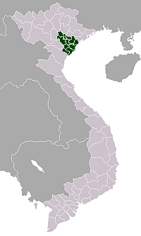
| Province | Hanoi |
| Number of wards | 10 |
| Seat | Cầu Diễn ward |
| Area | |
| • Total | 32.27 km2 (12.46 sq mi) |
| Population (2013) | |
| • Total | 232,894[1] |
| Time zone | UTC+7 (ICT) |
| Website | Official website (in Vietnamese) |
The district is known for its many new urban developments and several skyscrapers.[2]
Geography
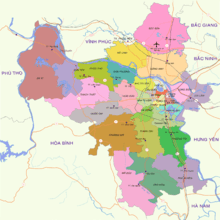
Nam Từ Liêm is bordered by Bắc Từ Liêm to the north, Cầu Giấy to the east, Thanh Xuân to the southeast, Hà Đông to the south and Hoài Đức to the west.
Administrative division
Nam Từ Liêm is divided into 10 wards (phường):[3]
- Cầu Diễn
- Mỹ Đình 1
- Mỹ Đình 2
- Trung Văn
- Đại Mỗ
- Tây Mỗ
- Mễ Trì
- Phú Đô
- Phương Canh
- Xuân Phương
Transportation
- Mỹ Đình Bus Station – a major bus terminal in western Hanoi, with metropolitan buses and long distance buses to provinces north and northwest of Hanoi.[4]
Notable buildings
 A new urban township in Nam Từ Liêm
 The Manor township


References
- Decree NQ132 to form Bac Tu Liem and Nam Tu Liem.
- Limit new high rises in Nam Từ Liêm
- Archived 2018-10-24 at the Wayback Machine Details of 23 wards of Bắc Từ Liêm and Nam Từ Liêm.
- Heated talks on reallocating bus routes among Hanoi bus stations
| Ba Đình District |
|  |
|---|---|---|
| Bắc Từ Liêm District |
| |
| Cầu Giấy District |
| |
| Đống Đa District |
| |
| Hà Đông District |
| |
| Hai Bà Trưng District |
| |
| Hoàn Kiếm District |
| |
| Hoàng Mai District |
| |
| Long Biên District |
| |
| Nam Từ Liêm District |
| |
| Tây Hồ District |
| |
| Thanh Xuân District |
| |
| Sơn Tây |
| |
| Ba Vì District |
| |
| Chương Mỹ District |
| |
| Đan Phượng District |
| |
| Đông Anh District |
| |
| Gia Lâm District |
| |
| Hoài Đức District |
| |
| Mê Linh District |
| |
| Mỹ Đức District |
| |
| Phú Xuyên District |
| |
| Phúc Thọ District |
| |
| Quốc Oai District |
| |
| Sóc Sơn District |
| |
| Thạch Thất District |
| |
| Thanh Oai District |
| |
| Thanh Trì District |
| |
| Thường Tín District |
| |
| Ứng Hòa District |
| |
Districts of the Red River Delta | ||
|---|---|---|
| Hanoi city |
|  |
| Haiphong city |
| |
| Bắc Ninh Province | ||
| Hà Nam Province | ||
| Hải Dương Province |
| |
| Hưng Yên Province | ||
| Nam Định Province | ||
| Ninh Bình Province | ||
| Thái Bình Province | ||
| Vĩnh Phúc Province |
| |
※ denotes provincial seat. | ||
This article is issued from Wikipedia. The text is licensed under Creative Commons - Attribution - Sharealike. Additional terms may apply for the media files.