Ứng Hòa District
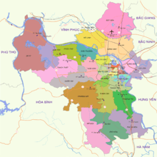
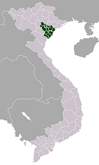
Ứng Hòa is a southern district (huyện) of Hanoi in the Red River Delta region of Vietnam. The River Đáy forms much of the western boundary with Mỹ Đức District. It covers an area of 183.72 square kilometres (70.93 sq mi), and as of 2005 it had a population of 193,731 people. It has 28 communes and one town.[1]
Ứng Hòa District Huyện Ứng Hòa | |
|---|---|
 Map of Ứng Hòa District | |
 Ứng Hòa District Map of Ứng Hòa District | |
| Coordinates: 20°56′12″N 105°50′35″E | |
| Country | |
| Province | Hanoi |
| Number of towns | 1 |
| Number of communes | 28 |
| Area | |
| • Total | 183.72 km2 (70.93 sq mi) |
| Population (2005) | |
| • Total | 193,731 |
| Time zone | UTC+7 (ICT) |
Administrative divisions
The district contains the following subdivisions:[1]
- Vân Đình (town)
Communes:
- Đại Hùng
- Đồng Tân
- Hòa Lâm
- Hòa Xá
- Liên Bạt
- Phù Lưu
- Sơn Công
- Trung Tú
- Viên An
- Cao Thành
- Đội Bình
- Đồng Tiến
- Hòa Nam
- Hồng Quang
- Lưu Hoàng
- Phương Tú
- Tảo Dương Văn
- Trường Thịnh
- Viên Nội
- Đại Cường
- Đông Lỗ
- Hoa Sơn
- Hòa Phú
- Kim Đường
- Minh Đức
- Quảng Phú Cầu
- Trầm Lộng
- Vạn Thá
References
- "Ứng Hòa" (in Vietnamese). Hanoi.gov.vn. Retrieved 15 August 2014.
| Ba Đình District |
|  |
|---|---|---|
| Bắc Từ Liêm District |
| |
| Cầu Giấy District |
| |
| Đống Đa District |
| |
| Hà Đông District |
| |
| Hai Bà Trưng District |
| |
| Hoàn Kiếm District |
| |
| Hoàng Mai District |
| |
| Long Biên District |
| |
| Nam Từ Liêm District |
| |
| Tây Hồ District |
| |
| Thanh Xuân District |
| |
| Sơn Tây |
| |
| Ba Vì District |
| |
| Chương Mỹ District |
| |
| Đan Phượng District |
| |
| Đông Anh District |
| |
| Gia Lâm District |
| |
| Hoài Đức District |
| |
| Mê Linh District |
| |
| Mỹ Đức District |
| |
| Phú Xuyên District |
| |
| Phúc Thọ District |
| |
| Quốc Oai District |
| |
| Sóc Sơn District |
| |
| Thạch Thất District |
| |
| Thanh Oai District |
| |
| Thanh Trì District |
| |
| Thường Tín District |
| |
| Ứng Hòa District |
| |
Districts of the Red River Delta | ||
|---|---|---|
| Hanoi city |
|  |
| Haiphong city |
| |
| Bắc Ninh Province | ||
| Hà Nam Province | ||
| Hải Dương Province |
| |
| Hưng Yên Province | ||
| Nam Định Province | ||
| Ninh Bình Province | ||
| Thái Bình Province | ||
| Vĩnh Phúc Province |
| |
※ denotes provincial seat. | ||
This article is issued from Wikipedia. The text is licensed under Creative Commons - Attribution - Sharealike. Additional terms may apply for the media files.