Ayutla, San Marcos
Ayutla (Spanish pronunciation: [aˈʝutla]) is a municipality in the San Marcos Department of Guatemala. It is situated along the Suchiate River natural border with Mexico in the southern part of the department. The municipality center is Ciudad Tecún Umán. There is a combined road and rail bridge known as Puente Rodolfo Robles linking Ayutla to Ciudad Hidalgo in Chiapas, Mexico.[3]
Ayutla | |
|---|---|
Municipality | |
 Main plaza and church in Ciudad Tecún Umán | |
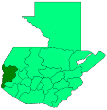
 Ayutla Location in Guatemala | |
| Coordinates: 14°40′41″N 92°08′31″W | |
| Country | |
| Department | |
| Municipal Seat | Ciudad Tecún Umán |
| Government | |
| • Mayor (2012-2020) | Erick Zúñiga[1] (UCN) |
| Area | |
| • Municipality | 125 km2 (48 sq mi) |
| Population (2018 census)[2] | |
| • Municipality | 37,049 |
| • Density | 300/km2 (770/sq mi) |
| • Urban | 23,574 |
| Climate | Aw |
There exists a railway, but because of poor maintenance nowadays it is not operational, but there are plans for its restoration.
In December 2019, the U.S. Treasury Department sanctioned Ayutla's mayor, Erick Zúñiga, under the Foreign Narcotics Kingpin Designation Act, alleging Zúñiga to be "a major drug trafficker," while also alleging that Zúñiga controls a drug trafficking organization and "supplies cocaine to Mexico’s Sinaloa Cartel ."[4]
Climate
Ayutla has tropical savanna climate (Köppen: Aw).
| Climate data for Ayutla | |||||||||||||
|---|---|---|---|---|---|---|---|---|---|---|---|---|---|
| Month | Jan | Feb | Mar | Apr | May | Jun | Jul | Aug | Sep | Oct | Nov | Dec | Year |
| Average high °C (°F) | 34.5 (94.1) |
34.9 (94.8) |
35.9 (96.6) |
35.8 (96.4) |
35.2 (95.4) |
33.7 (92.7) |
34.2 (93.6) |
34.3 (93.7) |
33.8 (92.8) |
33.8 (92.8) |
33.8 (92.8) |
33.9 (93.0) |
34.5 (94.1) |
| Daily mean °C (°F) | 27.1 (80.8) |
27.4 (81.3) |
28.7 (83.7) |
29.3 (84.7) |
29.2 (84.6) |
28.3 (82.9) |
28.5 (83.3) |
28.5 (83.3) |
28.3 (82.9) |
28.3 (82.9) |
27.8 (82.0) |
27.2 (81.0) |
28.2 (82.8) |
| Average low °C (°F) | 19.7 (67.5) |
20.0 (68.0) |
21.5 (70.7) |
22.8 (73.0) |
23.3 (73.9) |
22.9 (73.2) |
22.8 (73.0) |
22.7 (72.9) |
22.8 (73.0) |
22.8 (73.0) |
21.8 (71.2) |
20.5 (68.9) |
22.0 (71.5) |
| Average precipitation mm (inches) | 4 (0.2) |
1 (0.0) |
8 (0.3) |
53 (2.1) |
139 (5.5) |
293 (11.5) |
201 (7.9) |
205 (8.1) |
295 (11.6) |
225 (8.9) |
51 (2.0) |
6 (0.2) |
1,481 (58.3) |
| Source: Climate-Data.org[5] | |||||||||||||
Geographic location
Places adjacent to Ayutla, San Marcos | ||||||||||
|---|---|---|---|---|---|---|---|---|---|---|
| ||||||||||
See also

- San Marcos Department
- Rail transport in Central America
- Rail transport in Guatemala
- Rail transport in Mexico
References
- "San Marcos elige autoridades municipales". Prensa Libre (in Spanish). Guatemala. 8 September 2015. Retrieved 8 September 2015.CS1 maint: ref=harv (link)
- Citypopulation.de Population of departments and municipalities in Guatemala
- Dr. Rodolpho Robles Bridge
- "Treasury Sanctions Guatemalan Mayor and His Drug Trafficking Organization". home.treasury.gov. December 19, 2019. Retrieved December 21, 2019.
- "Climate: Ayutla". Climate-Data.org. Retrieved 5 September 2015.
- SEGEPLAN (n.d.). "Municipios del departamento de San Marcos". Secretaría General de Planificación (in Spanish). Archived from the original on 10 July 2015.CS1 maint: ref=harv (link)
External links
![]()