Avot, Côte-d'Or
Avot is a commune in the Côte-d'Or department in the Bourgogne-Franche-Comté region of eastern France.
Avot | |
|---|---|
 A street in Avot | |
.svg.png) Coat of arms | |
Location of Avot 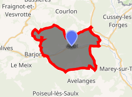
| |
 Avot  Avot | |
| Coordinates: 47°37′09″N 5°00′48″E | |
| Country | France |
| Region | Bourgogne-Franche-Comté |
| Department | Côte-d'Or |
| Arrondissement | Dijon |
| Canton | Is-sur-Tille |
| Intercommunality | CC Tille Venelle |
| Government | |
| • Mayor (2014-2020) | Bernard Guillemot |
| Area 1 | 21.67 km2 (8.37 sq mi) |
| Population (2017-01-01)[1] | 187 |
| • Density | 8.6/km2 (22/sq mi) |
| Time zone | UTC+01:00 (CET) |
| • Summer (DST) | UTC+02:00 (CEST) |
| INSEE/Postal code | 21041 /21580 |
| Elevation | 307–501 m (1,007–1,644 ft) (avg. 315 m or 1,033 ft) |
| 1 French Land Register data, which excludes lakes, ponds, glaciers > 1 km2 (0.386 sq mi or 247 acres) and river estuaries. | |
Geography
Avot is located some 40 km north by north-west of Dijon and 17 km west by north-west of Selongey. Access to the commune is by road D19 from Salives in the west which passes through the centre of the commune and the village before continuing east to join the D959 north of Marey-sur-Tille. The D19K goes north from the village to join the D112C east of Fraignot-et-Vesvrotte. Most of the commune is heavily forested with some small areas of farmland.[2]
The Tille river flows through the heart of the commune from west to east then continues southwards to join the Saône near Les Maillys. The Creuse flows from the north of the commune and joins the Tille at the village.[2]
Neighbouring communes and villages[2]
Places adjacent to Avot, Côte-d'Or | |
|---|---|
Heraldry
Arms of Avot |
Blazon: Paly of Argent and Gules of 6 pieces, debruised by a cross moline Sable, in chief Or charged with 3 escallops Azure. |
Administration

List of Successive Mayors[3]
| From | To | Name | Party | Position |
|---|---|---|---|---|
| 2001 | 2008 | Joël Leroy | ||
| 2008 | 2020 | Bernard Guillemot |
(Not all data is known)
Demography
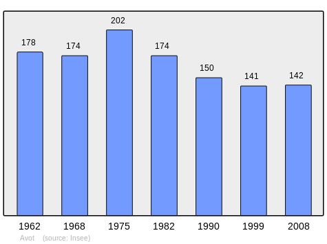
In 2010 the commune had 160 inhabitants. The evolution of the number of inhabitants is known from the population censuses conducted in the commune since 1793. From the 21st century, a census of communes with fewer than 10,000 inhabitants is held every five years, unlike larger communes that have a sample survey every year.[Note 1]
| 1793 | 1800 | 1806 | 1821 | 1831 | 1836 | 1841 | 1846 | 1851 |
|---|---|---|---|---|---|---|---|---|
| 265 | 260 | 245 | 273 | 287 | 311 | 325 | 343 | 352 |
| 1856 | 1861 | 1866 | 1872 | 1876 | 1881 | 1886 | 1891 | 1896 |
|---|---|---|---|---|---|---|---|---|
| 350 | 334 | 290 | 266 | 250 | 246 | 245 | 242 | 244 |
| 1901 | 1906 | 1911 | 1921 | 1926 | 1931 | 1936 | 1946 | 1954 |
|---|---|---|---|---|---|---|---|---|
| 234 | 212 | 210 | 175 | 220 | 198 | 206 | 230 | 202 |
| 1962 | 1968 | 1975 | 1982 | 1990 | 1999 | 2006 | 2010 | - |
|---|---|---|---|---|---|---|---|---|
| 178 | 174 | 202 | 174 | 150 | 141 | 132 | 160 | - |
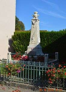
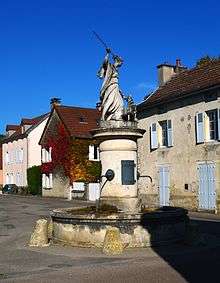
Avot Picture Gallery
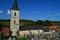 Avot Church
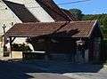 A Lavoir (Public Laundry) in Avot
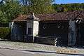 A Lavoir (Public Laundry) in Avot
 The Tille river at Avot
See also
Notes
- At the beginning of the 21st century, the methods of identification have been modified by Law No. 2002-276 of 27 February 2002 Archived 6 March 2016 at the Wayback Machine, the so-called "law of local democracy" and in particular Title V "census operations" allows, after a transitional period running from 2004 to 2008, the annual publication of the legal population of the different French administrative districts. For communes with a population greater than 10,000 inhabitants, a sample survey is conducted annually, the entire territory of these communes is taken into account at the end of the period of five years. The first "legal population" after 1999 under this new law came into force on 1 January 2009 and was based on the census of 2006.
References
- "Populations légales 2017". INSEE. Retrieved 6 January 2020.
- Google Maps
- List of Mayors of France (in French)
External links
| Wikimedia Commons has media related to Avot. |
- Avot on the old IGN website (in French)
- Avot on Lion1906
- Avot on Google Maps
- Avot on Géoportail, National Geographic Institute (IGN) website (in French)
- Avot on the 1750 Cassini Map
- Avot on the INSEE website (in French)
- INSEE (in French)
| Authority control |
|
|---|