Atlas Fire
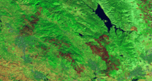
The Atlas Fire was a 2017 wildfire burning in Napa County, California north of the city of Napa, near Napa Soda Springs. It was one of fourteen large fires simultaneously burning in eight Northern California counties, in what was called the "Northern California firestorm".[2] Governor Jerry Brown declared a state of emergency.[3][4]
| Atlas Fire | |
|---|---|
 Atlas fire and adjacent fires | |
| Location | Napa County, California |
| Coordinates | 38.39206°N 122.24367°W |
| Statistics[1] | |
| Date(s) | October 8, 2017 – October 28, 2017 |
| Burned area | 51,057 acres (207 km2) |
| Buildings destroyed | 781 |
| Deaths | 6 |
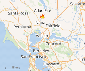 |
| Location of Atlas Fire |
The fire, which started on October 8, had by October 12 burned 51,057 acres (207 km2) of land, and was 77% contained.[5][6] By October 12, the fire stretched from Lake Berryessa south to Napa, but a firebreak was established across Atlas Peak Road.[6]
The Fire
The fire began about 10 p.m. October 8 on Atlas Peak Road Atlas Peak. It started south, fed by winds, gusting to 28 miles per hour, and low relative humidity at 12%.[7]
On October 12, winds were forecast to reach 40 mph, but were lighter than expected, slowing the growth of the fire.[6]
Evacuations
Evacuations started at Silverado Resort,[8] and at Vichy Avenue and Hagen Road area, then Montecito Boulevard and Monte Vista Avenue.[9]
After the evacuation center at Crosswalk Church quickly reached maximum capacity, one was opened at Napa Valley College and St. Apollinaris Catholic Church. There are other evacuations centers such as:
- Allan Witt Park, 1741 W Texas St, Fairfield,
- Solano Community College, 4000 Suisun Valley Rd, Fairfield, and
- Fairfield High School, 205 E. Atlantic Avenue, Fairfield.[9]
- Sonoma Raceway open their campgrounds.[10][11]
The evacuations for Solano County are Upper and Lower Green Valley, Eastridge, and the community of twin sisters along Suisun Valley road. The advisory is for the Lakes, and The Shopping Centers for Cordelia.[12] In Sonoma, there were mandatory evacuation orders first at Seventh Street East, Castle Road, and Lovall Valley Road; then at East Napa Street.[13] An evacuation advisory was issued for parts of the city of Napa.[14]
See also
References
- "Atlas Fire". CALFIRE. Archived from the original on 2017-10-09. Retrieved October 9, 2017.
- "At least 23 dead, 2,000 structures lost in Northern California firestorm, among worst in state's history". Los Angeles Times. 2017-10-09. ISSN 0458-3035. Retrieved 2017-10-10.
- "At least 10 dead, 1,500 structures lost in Northern California firestorm, among worst in state's history". 9 October 2017 – via LA Times.
- Hui, Mary; Lac, J. Freedom du (2017-10-12). "'Armageddon': Apocalyptic images show the devastation caused by deadly wine-country fires". Washington Post. ISSN 0190-8286. Retrieved 2017-10-12.
- "North Bay Fire Updates: Tubbs Fire 10% Contained, Atlas Fire 3% Contained". Eater SF. Retrieved 2017-10-12.
- "Overnight winds were milder than expected, keeping Atlas fire's growth to a minimum". Los Angeles Times. October 12, 2017.
- "At least 10 killed by fast-moving California wildfires, fire officials say".
- Strege, John. "Fire forces evacuation of Silverado Resort hours after Safeway Open ended - Golf Digest". Golf Digest. Retrieved 2017-10-09.
- Yune, Howard. "Wind-blown fires in Napa and Calistoga prompt major night evacuations, school closures". Napa Valley Register. Lee Enterprises.
- "Sonoma Raceway opening campground to evacuees seeking temporary refuge". Retrieved 2017-10-12.
- Keller, Matt (2017-10-12). "Atlas Fire flaring up in Napa County". ABC7 San Francisco. Archived from the original on 2017-10-13. Retrieved 2017-10-12.
- "Encroaching Atlas Fire Spurs Evacuations For Parts Of Fairfield".
- "Live updates: Fire death toll at 29 in Northern California fires".
- Staff, KCRA (2017-10-12). "New evacuations ordered as Napa County wildfires grow". KCRA. Retrieved 2017-10-12.
External links
| Pre-2000 |
|
|---|---|
| 2002 | |
| 2003 | |
| 2004 | |
| 2005 | |
| 2006 | |
| 2007 | |
| 2008 | |
| 2009 | |
| 2010 | |
| 2011 | |
| 2012 | |
| 2013 | |
| 2014 | |
| 2015 | |
| 2016 | |
| 2017 | |
| 2018 | |
| 2019 | |
| 2020 | |
| |