Walker Fire
The Walker Fire was a wildfire that was burning in Genesee Valley in the Plumas National Forest approximately 11 miles east of the community of Taylorsville in Plumas County, California.[1] The blaze was reported on Wednesday, September 4, 2019 and immediately expanded in size over its several days of burning. The fire actively threatened homes from Genesee Valley to Antelope Road.[2] Areas of the Plumas National Forest remain closed.[1]
| Walker Fire | |
|---|---|
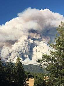 Walker Fire on September 7, 2019 | |
| Location | Genesee Valley, Plumas County, California |
| Coordinates | 40.053°N 120.669°W |
| Statistics[1] | |
| Date(s) | September 4, 2019 -- September 25, 2019 |
| Burned area | 54,612 acres (22,101 ha) |
| Cause | Under investigation |
| Map | |
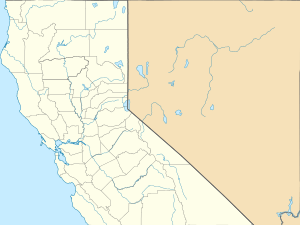 Location in Northern California | |
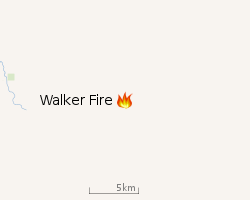 |
| Location of Walker Fire |
Events
Early in the afternoon of Wednesday, September 4, a fire was reported burning south of the Flournoy Bridge in Genesee Valley. First responders estimated the size of the fire to be roughly between 3 and 5 acres, however, burning with a critical rate of spread due to strong and erratic winds.[3][4] By late evening of that day, the fire was over 750 acres in size as the community of Genesee Valley was placed under a mandatory evacuation order.[5][4] On Thursday, September 5, firefighters were reportedly making good progress as the fire was at 5% containment with 850 acres burned.[3] However, later in the day, downdraft winds from late afternoon thunderstorms caused spotting ahead of the fireline which expanded the burn area to encompass up to 1,800 acres (7 km2).[4]
By Friday, September 6, fire activity had picked up significantly as further erratic, unpredictable winds and dry conditions lead the advancing fireline further out of Plumas National Forest towards the northeast spurring new voluntary evacuations of structures below Forest Road 26N11.[4] The fire, originally burning 2,000 acres (8 km2) Friday morning, had exploded to well over 17,000 acres (69 km2) acres by Friday night due to the severe weather conditions, sending up a massive smoke column that was reportedly seen from as far as Reno.[6] The fire was then over 24,000 acres (97 km2) acres in size by Saturday morning as containment remained at 0%.[6]
On September 10, the Walker Fire had grown to 47,340 acres (192 km2) and was 12 percent contained. The Lassen County Fairground evacuation center was closed that morning.[7] The majority of residential evacuation orders were lifted, except the Murdock Crossing and Stoney areas.[8] The next evening, the fire continued to grow, but was 28 percent contained. Crews extended dozer lines and handlines to expand the containment.[1][9] Structural defense was put in place for buildings at Murdock Crossing and mop up continued at Antelope Lake, Round Mountain and the eastern side of the fire. However, by the morning of September 14, the fire had expanded to 54,612 acres (22,101 ha) and was 97 percent contained.[10]
Evacuations and closures
Select areas of Plumas National Forest were closed, specifically within the Mt. Hough and Beckwourth Ranger Districts. Road closures included : Janesville Grade, Genesee Valley Road at the Flournoy Bridge, Antelope Lake Road from the Flournoy Bridge to Antelope Dam, and beginning at the Flournoy Bridge turnoff, and 111 Beckwourth-Genesee road through the fire area. Highway 395 remained open to the public.[10] The Antelope Lake Road is still closed as of 5/22/2020.
Impact
Communities along Highway 395 from Thunder Mountain Road (Wales Canyon) to the Laufman Grade (Old Highway 59), including the communities of Murdock Crossing, Stoney, Milford and Brockman Canyon, were under mandatory evacuation.[11][12]
References
- "Walker Fire". InciWeb. Retrieved September 4, 2019.
- Moore, Debra. "Evacuations underway in Walker Fire". Plumas News. Retrieved 5 September 2019.
- Moore, Debra. "Walker Fire Day 3 updates". Plumas News. Retrieved 6 September 2019.
- Staff, YubaNet. "Walker, Genesee". Yuba Net. Retrieved 4 September 2019.
- "Continued rapid rate of spread and short range spotting observed. Evacs and road closures". YubaNet. Retrieved 4 September 2019.
- Ervin III, Mack. "Massive wildfire burning in Plumas National Forest in Northern CA. Evacuations ordered". Sac Bee. Retrieved 7 September 2019.
- "WALKER FIRE AM UPDATE 9-10-19 - InciWeb the Incident Information System". InciWeb. Plumas National Forest. Retrieved 10 September 2019.
- "WALKER FIRE PM UPDATE 9-10-19 - InciWeb the Incident Information System". InciWeb. Plumas National Forest. Retrieved 11 September 2019.
- "WALKER FIRE AM UPDATE 9-11-19 - InciWeb the Incident Information System". InciWeb. Plumas National Forest. Retrieved 11 September 2019.
- "Walker Fire AM Update 9-18-2019 - InciWeb the Incident Information System". InciWeb. Plumas National Forest. Retrieved 18 September 2019.
- "WALKER FIRE PM UPDATE 9-9-19 - InciWeb the Incident Information System". InciWeb. Plumas National Forest. Retrieved 10 September 2019.
- "Walker Fire Information - InciWeb the Incident Information System". InciWeb. Plumas National Forest. Retrieved 13 September 2019.
![]()
External links

| Pre-2000 |
|
|---|---|
| 2002 | |
| 2003 | |
| 2004 | |
| 2005 | |
| 2006 | |
| 2007 | |
| 2008 | |
| 2009 | |
| 2010 | |
| 2011 | |
| 2012 | |
| 2013 | |
| 2014 | |
| 2015 | |
| 2016 | |
| 2017 | |
| 2018 | |
| 2019 | |
| 2020 | |
| |