Athée, Côte-d'Or
Athée is a French commune in the Côte-d'Or department in the Bourgogne-Franche-Comté region of eastern France.
Athée | |
|---|---|
.JPG) The Château of Athée | |
.svg.png) Coat of arms | |
Location of Athée 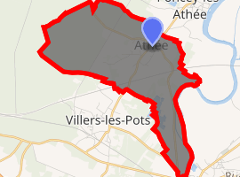
| |
 Athée  Athée | |
| Coordinates: 47°13′51″N 5°22′20″E | |
| Country | France |
| Region | Bourgogne-Franche-Comté |
| Department | Côte-d'Or |
| Arrondissement | Dijon |
| Canton | Auxonne |
| Intercommunality | CC Auxonne Pontailler Val Saône |
| Government | |
| • Mayor (2014-2020) | Serge Perron |
| Area 1 | 9.43 km2 (3.64 sq mi) |
| Population (2017-01-01)[1] | 781 |
| • Density | 83/km2 (210/sq mi) |
| Time zone | UTC+01:00 (CET) |
| • Summer (DST) | UTC+02:00 (CEST) |
| INSEE/Postal code | 21028 /21130 |
| Elevation | 182–232 m (597–761 ft) (avg. 203 m or 666 ft) |
| 1 French Land Register data, which excludes lakes, ponds, glaciers > 1 km2 (0.386 sq mi or 247 acres) and river estuaries. | |
The inhabitants of the commune are known as Athéens or Athéennes.[2]
Geography
Athée is located in the Natural Region of Val de Saône immediately north of Auxonne and south of Poncey-lès-Athée. Access to the commune is by the D24 road from Auxonne which passes through the length of the commune and the village and continues north-west to Magny-Montarlot. The D976 comes from Poncey-lès-Athée in the north and passes through the village continuing south-west to join Route Nationale 5 west of Auxonne.[3]
The first phase of the LGV Rhin-Rhône (140 km long) between Villers-les-Pots (Côte-d'Or) and Petit-Croix (Territoire de Belfort), opened in 2011, traverses the commune but there is no station. The nearest railway stations are at Villers-les-Pots (3 km) and Tillenay station at Auxonne (5 km), both on the Dijon to Vallorbe line.
The west and north-west of the commune are heavily forested with the rest of the commune farmland.[3]
The Saône river forms the eastern border of the commune and there are drainage Ditches in the forests (Grande Bois Defendu and Bois des Noues) and Canal pounds in the south of the commune.[3]
Geologically, Athée is on the Bresse Graben in the Saône Plain. The soil is sandy clay.
Neighbouring communes and villages[4]
Places adjacent to Athée, Côte-d'Or | |
|---|---|
Toponymy
The name Athée comes from the Latin Attegiae, meaning "huts" or "Shepherd's cabins" which constituted the original village. Depending on the time and the writer the village has been called:[5]
- Attegiae and Ateiae (7th century),
- Ateias (9th century),
- Attegia (11th century),
- Ateae (12th century),
- Atheae and Athées (13th century),
- Estées (14th century),
- Athée (16th century),
- Attée (17th century),
- Athé and Athey (18th century),
- Athée (since 1750).[6]
History
The oldest mention of Athée recognised by the majority of historians was in 679 in a Charter of the Cartulary of the Abbey Saint-Bénigne of Dijon.[5]
The Lordship of Athée - consisting of Athée, Poncey, the "Grange Lochère" located at the end of a bridge over the Saône, and Auxonne,[7] as well as Magny-lès-Auxonne[8] 4, was probably founded in the early High Middle Ages.
It is located on Holy Roman Empire land and is one of the three territories which were fiefs of Saint-Seine-sur-Vingeanne depending on the County of Auxonne, run by counts for the monks of the priory of Saint-Vivant-en-Amous. The Lord of Athée was the vassal of Saint-Seine who was himself a vassal of the Count of Auxonne who in turn was a vassal of the monks of Saint-Vivant, who were vassals of the Emperor of the Holy Roman Empire[9]
From 1237 the Count of Auxonne was replaced in the chain of vassalage by the Duke of Burgundy following an exchange of lands between Hugh IV, Duke of Burgundy and John, Count of Chalon.
From 1366 to the French Revolution the Lordship of Athée was held by co-lords who were canons of Sainte-Chapelle de Dijon on the one hand and Lay Lords (the Laverne, Senevoy, Moussier families) on the other.[7]
In 1516 the lordship became subject to the Kingdom of France and depended on the bailiwick of Auxonne and the Généralité de Bourgogne (Generality of Burgundy).[10]
Between 1790 and 1794 Athée, separately from Poncey and Magny, became a French commune depending on the Canton of Auxonne, the district of Saint-Jean-de-Losne, and the department of Côte-d'Or.[11]
Since 1801 the commune has depended on the Canton of Auxonne, the Arrondissement of Dijon, the department of Côte-d'Or, and, since 1960, the region of Burgundy.[11]
Until 1790 Athée was the seat of a Rector and the patron was the Sacristan of Dijon Cathedral depending primarily on the Deanery of Oscheret, then the Archpriest of Genlis of the Diocese of Chalon.[5]
Today Athée is part of the parish of Auxonne, the deanery of Vingeanne-Saône, and the Diocese of Dijon.[12]
Historical Highlights
- around 1450: the building the "Old Chateau" of Athée.[13]
- 1516: Athée becomes French.
- 1674: King Louis XIV came to besiege the county capital, Dole. His wife, Queen Maria Theresa of Spain and his son Louis, Grand Dauphin of France spent the night at the house of the Count de Moussier - the "Old Chateau" of Athée to avoid the plague then raging in Auxonne.[14]
- 1793: Athée becomes a commune.[11]
- 1856-1857: Reconstruction of the Church of the Nativity of Our Lady keeping the choir from the 13th century.
- 1868: building of the boys' school which is now the town hall.
- 1875: foundation of the Athée retirement home by Victor and Fanny Moussier.
- 1877 and 1885: two fires ravaged the village.
- 1915: Athée was occupied by the Corps expéditionnaire d'Orient (Oriental Expeditionary Force) before their embarkation at the military quay in Villers-les-Pots.[13]
Administration
List of Successive Mayors[15]
| From | To | Name | Party | Position |
|---|---|---|---|---|
| 2001 | 2008 | Jean-Louis Martin | ||
| 2008 | Serge Perron | Name |
(Not all data is known)
Demography
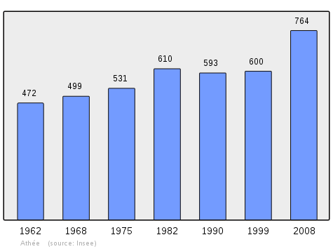
In 2010 the commune had 780 inhabitants. The evolution of the number of inhabitants is known from the population censuses conducted in the commune since 1793. From the 21st century, a census of communes with fewer than 10,000 inhabitants is held every five years, unlike larger towns that have a sample survey every year.[Note 1]
| 1793 | 1800 | 1806 | 1821 | 1831 | 1836 | 1841 | 1846 | 1851 |
|---|---|---|---|---|---|---|---|---|
| 463 | 469 | 402 | 467 | 538 | 492 | 482 | 509 | 516 |
| 1856 | 1861 | 1866 | 1872 | 1876 | 1881 | 1886 | 1891 | 1896 |
|---|---|---|---|---|---|---|---|---|
| 540 | 510 | 509 | 509 | 548 | 549 | 570 | 539 | 531 |
| 1901 | 1906 | 1911 | 1921 | 1926 | 1931 | 1936 | 1946 | 1954 |
|---|---|---|---|---|---|---|---|---|
| 521 | 506 | 503 | 451 | 441 | 469 | 470 | 482 | 464 |
| 1962 | 1968 | 1975 | 1982 | 1990 | 1999 | 2006 | 2010 | - |
|---|---|---|---|---|---|---|---|---|
| 472 | 499 | 531 | 610 | 593 | 600 | 694 | 780 | - |
Lieux et monuments
- A Château (probably 15th century), called "Vieux-Château" (Old Chateau), Rue du Centre;
- 3 Wayside Crosses (19th century), Rue de l'Église, Rue du Centre, and Rue de la Saône;
- A Girls' School (19th century), today a house, Rue du Centre;
- The Church of Notre-Dame-de-la-Nativité (19th century with a choir from the 13th century), Rue de l'Église;
- A Lavoir (Public laundry) (19th century), Rue de l'Égalité;
- The Town Hall (19th century), Rue de l'Égalité;
- A Retirement home "Les Logis du Parc Victor et Fanny Moussier" (1875), Rue du Centre;
- A Weighbridge (20th century), Rue du Centre/Rue de la Bascule;
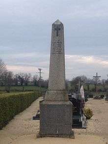
- The War Memorial (20th century), Rue de l'Église;
- 2 Wells, Rue de l'Égalité and Rue du Centre;
The Church of Notre-Dame-de-la-Nativité contains the Tombstone of Guillaume Bouot (16th century)![]()
%2C_c%C3%B4t%C3%A9_cour.JPG) The "Old château", side courtyard
The "Old château", side courtyard%2C_Croix_2.JPG) Wayside Cross, Rue de Saône
Wayside Cross, Rue de Saône%2C_Croix_3.JPG) Wayside Cross, Rue du Centre
Wayside Cross, Rue du Centre.JPG) Old Girls' School
Old Girls' School.JPG) Church of Notre-Dame-de-la-Nativité
Church of Notre-Dame-de-la-Nativité%2C_lavoir.JPG) Lavoir (Public laundry)
Lavoir (Public laundry).JPG) The Town Hall
The Town Hall.JPG) The Retirement home
The Retirement home%2C_bascule.JPG) The weighbridge
The weighbridge.JPG) The War Memorial
The War Memorial%2C_puits_1.JPG) Well 1, Rue de l'Égalité
Well 1, Rue de l'Égalité%2C_puits_2.JPG) Well 2, Rue du Centre
Well 2, Rue du Centre%2C_puits_3.JPG) Well 2, Rue du Centre
Well 2, Rue du Centre%2C_puits_4.JPG) Well 2, Rue du Centre
Well 2, Rue du Centre
Notable people linked to the commune
- Bernard Laverne, President of the Parliament of Dijon, Co-lord of Athée (16th century)
- King Louis XIV, King of France, Maria Theresa of Spain, Queen of France, and Louis, Grand Dauphin of France, stayed one night at the Château of Athée in 1674
See also
Notes and references
Notes
- At the beginning of the 21st century, the methods of identification have been modified by Law No. 2002-276 of 27 February 2002 Archived 6 March 2016 at the Wayback Machine, the so-called "law of local democracy" and in particular Title V "census operations" allows, after a transitional period running from 2004 to 2008, the annual publication of the legal population of the different French administrative districts. For communes with a population greater than 10,000 inhabitants, a sample survey is conducted annually, the entire territory of these communes is taken into account at the end of the period of five years. The first "legal population" after 1999 under this new law came into force on 1 January 2009 and was based on the census of 2006.
References
- "Populations légales 2017". INSEE. Retrieved 6 January 2020.
- Inhabitants of Côte-d'Or (in French)
- Google Maps
- Géoportail, IGN (in French)
- Roserot A., Topographic dictionary of Côte d’Or, imprimerie nationale, Paris, 1924. pp. 15-16 (in French)
- Cassini Map 1750 - Athée
- Courtépée C., General description and particulars of the Duchy of Burgundy, Vol. 2, Causse, Dijon, 1777. pp. 268-269 (in French)
- Courtépée C., General description and particulars of the Duchy of Burgundy, Vol. 2, Causse, Dijon, 1777. p. 288 (in French)
- Millot L., Critical study of the origins of the city of Auxonne – its feudal condition and its franchises, Imprimerie Darantière, Dijon, 1899, p. 136. (in French)
- An administrative division created in 1542 with its seat in Dijon
- Communal Notice on Athée, on the Cassini database of EHESS (in French)
- Diocese of Dijon official website (in French)
- Caramanian P. "Athée, As many good Christians as anywhere else" in Le Bien Public - Les Dépêches, consulted on 20 June 2013 Archived 3 March 2016 at the Wayback Machine (in French)
- Caramanian P. "Athée, The night of the Grand Dauphin" in Le Bien Public - Les Dépêches, consulted on 20 June 2013 Archived 3 March 2016 at the Wayback Machine (in French)
- List of Mayors of France (in French)
- Ministry of Culture, Palissy PM21000096 Tombstone of Guillaume Bouot (in French)
External links
| Wikimedia Commons has media related to Athée (Côte-d'Or). |
- Athée on the old IGN website (in French)
- Athée on Google Maps
- Athée on Géoportail, National Geographic Institute (IGN) website (in French)
- Athée on the 1750 Cassini Map
- Athée on the INSEE website (in French)
- INSEE (in French)