Armidale, New South Wales
Armidale is a city in the Northern Tablelands, New South Wales, Australia.[2] Armidale had a population of 24,504 as at June 2018.[1] It is the administrative centre for the Northern Tablelands region. It is approximately halfway between Sydney and Brisbane at the junction of the New England Highway and Waterfall Way. Armidale traditional owners are Anaiwan people. Many Gumbaynggirr people have settled in Armidale since colonisation.
| Armidale New South Wales | |||||||||
|---|---|---|---|---|---|---|---|---|---|
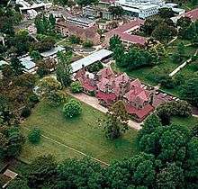
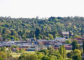 Looking across Armidale city, December 2013 | |||||||||
Armidale | |||||||||
| Coordinates | 30°30′S 151°39′E | ||||||||
| Population | 24,504 (2018)[1] | ||||||||
| Established | 1849 | ||||||||
| Postcode(s) | 2350, 2351 | ||||||||
| Elevation | 980 m (3,215 ft) | ||||||||
| Location | |||||||||
| LGA(s) | Armidale Regional Council | ||||||||
| County | Sandon | ||||||||
| State electorate(s) | Northern Tablelands | ||||||||
| Federal Division(s) | New England | ||||||||
| |||||||||
Geography
Armidale is on the banks of Dumaresq Creek, in the Northern Tablelands in the New England region about midway between Sydney and Brisbane at an altitude (980 m AHD)[3] ranging from 970 metres at the valley's floor to 1,110 metres above sea level at the crests of the hills. A short distance to the east of Armidale are heavily forested steep gorges dropping down to the eastern coastal plain. Large parts of the highlands are covered by Palaeozoic aged metamorphosed sedimentary rocks. Intruding into these meta-sediments are granite plutons which decompose to form sandy soil, slightly deficient in nutrients. There are also basalt flows which are more fertile for the soil substrates. Those areas away from the deep gorge country tend to display gently undulating terrain mainly used for pastures and where granites occur the areas are usually covered in bushland.
The area contains a number of places of outstanding natural beauty and scientific interest as well as several World Heritage national parks including the New England National Park and the Oxley Wild Rivers National Park. To the west is Mount Yarrowyck Nature Reserve.
The coastal plain can be reached directly at Coffs Harbour via Waterfall Way to Dorrigo and Bellingen on the Bellinger River, a two-hour drive.
Pollution levels
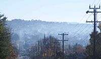
Armidale has a noted problem with air pollution caused by the use of solid fuel domestic wood heaters during the winter months.[4] A peer-reviewed study carried out by the University of New England found winter woodsmoke causes 8.8 additional visits per day to GPs in Armidale for respiratory complaints, i.e., about 750 additional visits per year.[5] Another peer-reviewed study estimated the use of wood heaters in Armidale was responsible for about 11.5 premature deaths per year with estimated annual health cost of $14.95 million – about $4720 per year for every woodheater in the city.[6] A local retired doctor (now Associate Professor at the UNE Medical school) said he is so concerned by the wood smoke situation, he urges people with respiratory problems to leave town.[7]
Climate
Armidale has a subtropical highland climate (Köppen climate classification: Cfb[8]) influence. Armidale's elevation gives it a milder climate, but the summers are still very warm. Winters are long and cool, with many frosty nights. Snowfall is rare, on average only one day in every three years.
In Armidale, the presence of four distinct seasons make it climatically unlike most of Australia; hence, the "New England" moniker and the autumn colours are notable features of the city. Summers are characterised by warm to very warm days followed almost always by cool, sometimes cold, nights. Thunderstorms often produce heavy falls of rain and occasionally hail in the afternoons and early evenings, also bringing a sudden drop in temperature. Unlike nearby coastal areas, Armidale does not usually experience high humidity levels making most of the summer days quite comfortable. Temperatures exceed 30 °C on average of 13 days per year, but rarely reach higher than 35 °C.[9] The highest temperature recorded at Armidale Airport was 37.1 °C, recorded in February 2017.
As the leaves turn yellow and fall, day temperatures are mostly still warm, particularly in March and April. Days are sunny, the thunderstorm season is over, and rain becomes more sporadic. Nights become colder, and residents often awake to a thick fog blanketing the Armidale valley, but by 9 am fogs have cleared to be followed by a bright sunny day. The year's first frosts usually occur in April, but they are not severe.
Winters are cold; overnight temperatures drop below −5 °C with frost on the ground. These cold frosty mornings are usually followed by sunny days. Day temperatures may make it as high as 16 °C, but sometimes may not climb beyond 10 °C.[9] These are typical Northern Tablelands winter days with westerly winds, bleak grey clouds, and showers of rain and very occasionally snow. Rainfall during the winter months not infrequent but is usually light.
In spring temperatures are warmer, although occasional morning frosts still can continue well into October. September is usually a pleasantly mild but windy month, and by late October with increasing heat and humidity the thunderstorm season is starting with increasing rainfalls. The spring months produce the most variable weather of the year. A week of very warm sunny weather can be followed by several milder days with temperatures right back at winter levels before gradually warming up again. This cycle often repeats itself many times until the start of summer.
| Climate data for Armidale Airport | |||||||||||||
|---|---|---|---|---|---|---|---|---|---|---|---|---|---|
| Month | Jan | Feb | Mar | Apr | May | Jun | Jul | Aug | Sep | Oct | Nov | Dec | Year |
| Record high °C (°F) | 37.0 (98.6) |
37.1 (98.8) |
32.4 (90.3) |
27.7 (81.9) |
23.3 (73.9) |
21.7 (71.1) |
19.9 (67.8) |
26.8 (80.2) |
28.2 (82.8) |
31.6 (88.9) |
35.0 (95.0) |
33.7 (92.7) |
37.1 (98.8) |
| Average high °C (°F) | 26.1 (79.0) |
25.2 (77.4) |
23.2 (73.8) |
19.8 (67.6) |
15.8 (60.4) |
12.7 (54.9) |
12.1 (53.8) |
13.9 (57.0) |
17.7 (63.9) |
20.5 (68.9) |
22.7 (72.9) |
24.8 (76.6) |
19.5 (67.1) |
| Average low °C (°F) | 13.4 (56.1) |
13.1 (55.6) |
11.4 (52.5) |
7.8 (46.0) |
4.3 (39.7) |
2.5 (36.5) |
1.3 (34.3) |
1.8 (35.2) |
4.7 (40.5) |
7.3 (45.1) |
10.1 (50.2) |
12.1 (53.8) |
7.5 (45.5) |
| Record low °C (°F) | 4.5 (40.1) |
4.1 (39.4) |
1.1 (34.0) |
−3.3 (26.1) |
−5.1 (22.8) |
−6.0 (21.2) |
−7.0 (19.4) |
−6.6 (20.1) |
−4.9 (23.2) |
−3.1 (26.4) |
−1.6 (29.1) |
1.3 (34.3) |
−7.0 (19.4) |
| Average rainfall mm (inches) | 91.0 (3.58) |
94.1 (3.70) |
60.9 (2.40) |
36.0 (1.42) |
40.3 (1.59) |
52.1 (2.05) |
41.1 (1.62) |
45.7 (1.80) |
51.8 (2.04) |
72.2 (2.84) |
99.0 (3.90) |
97.6 (3.84) |
781.8 (30.78) |
| Average rainy days (≥ 0.2mm) | 11.7 | 12.5 | 11.9 | 11.3 | 11.9 | 15.0 | 12.6 | 9.8 | 10.0 | 10.8 | 12.8 | 13.3 | 143.6 |
| Source: Bureau of Meteorology[9] | |||||||||||||
| Climate data for Armidale | |||||||||||||
|---|---|---|---|---|---|---|---|---|---|---|---|---|---|
| Month | Jan | Feb | Mar | Apr | May | Jun | Jul | Aug | Sep | Oct | Nov | Dec | Year |
| Record high °C (°F) | 37.1 (98.8) |
37.6 (99.7) |
33.8 (92.8) |
28.0 (82.4) |
24.8 (76.6) |
22.3 (72.1) |
21.2 (70.2) |
27.4 (81.3) |
28.7 (83.7) |
32.4 (90.3) |
35.6 (96.1) |
34.4 (93.9) |
37.6 (99.7) |
| Average high °C (°F) | 26.9 (80.4) |
25.9 (78.6) |
23.9 (75.0) |
20.4 (68.7) |
16.7 (62.1) |
13.5 (56.3) |
13.0 (55.4) |
14.8 (58.6) |
18.6 (65.5) |
21.3 (70.3) |
23.4 (74.1) |
25.5 (77.9) |
20.3 (68.5) |
| Average low °C (°F) | 12.8 (55.0) |
12.7 (54.9) |
10.6 (51.1) |
6.8 (44.2) |
2.1 (35.8) |
0.8 (33.4) |
−0.4 (31.3) |
−0.2 (31.6) |
2.8 (37.0) |
5.8 (42.4) |
9.3 (48.7) |
11.4 (52.5) |
6.2 (43.2) |
| Record low °C (°F) | 2.6 (36.7) |
2.5 (36.5) |
−1.7 (28.9) |
−5.8 (21.6) |
−7.9 (17.8) |
−11.2 (11.8) |
−10.8 (12.6) |
−8.6 (16.5) |
−6.2 (20.8) |
−3.5 (25.7) |
−3.0 (26.6) |
−0.5 (31.1) |
−11.2 (11.8) |
| Average rainfall mm (inches) | 86.9 (3.42) |
95.4 (3.76) |
67.8 (2.67) |
39.2 (1.54) |
31.3 (1.23) |
44.2 (1.74) |
38.3 (1.51) |
45.9 (1.81) |
45.6 (1.80) |
66.7 (2.63) |
97.8 (3.85) |
86.9 (3.42) |
746 (29.38) |
| Average rainy days (≥ 0.2mm) | 11.0 | 11.3 | 10.3 | 8.5 | 7.6 | 10.9 | 9.3 | 8.1 | 8.0 | 9.8 | 11.9 | 11.6 | 118.3 |
| Source: Bureau of Meteorology[10] | |||||||||||||
Hailstorms

Armidale has been prone to severe hailstorms and experienced three such storms over the ten-year period from 1996 to 2006.
On 29 September 1996, hail of up to 80 millimetres (3.1 in) in diameter and southerly winds of up to 150 kilometres per hour (93 mph) were reported at the airport weather station. The area was declared a disaster zone and State Emergency Service crews were brought in from across the state. Damage was estimated to be in excess of A$200 million.[11]
On 1 January 2000, many homes were damaged by extreme weather conditions which brought large hail stones, strong winds and flash flooding.[12]
On 21 December 2006, hail stones, high winds and flash flooding damaged more than 1,000 homes and destroyed the Armidale Livestock Exhibition Centre which collapsed entirely under the weight of accumulated hail. The city was declared a state of emergency by New South Wales Premier Morris Iemma the following day.[13][14]
Transport

The Armidale railway station is on the Main North railway line and is served by daily passenger trains to and from Sydney. Armidale's airport has five daily scheduled flights to and from Sydney with Qantaslink. Regional airline Fly Corporate operates a scheduled air service with flights to and from Brisbane.[15] Armidale Airport, at 1,084 metres (3,556 ft), is the highest licensed airport in New South Wales.
The city is linked further north by daily coach to Tenterfield provided by NSW TrainLink. Other bus companies such as Greyhound also provide numerous daily services. Local city services are provided on six different routes by Edwards Coaches and Armidale is serviced by 16 taxis.
Although the hills to the north and the south can be a challenge, cycling is an option to get around Armidale. A cycleway exists from the University of New England through the city to the residential areas on the eastern side of city. This cycleway snakes back towards Ben Venue School. The passage through the city provides easy access for cyclists to the shopping centres. Bicycle racks are in strategic locations around the city centre, including at The Armidale Food Emporium, The Armidale Plaza, and Centro Armidale. Places are also provided outside the Armidale Dumeresq War Memorial Library, and at either end of the Mall. A maze of marked cycleways on the shoulder of the roads in the city's southern residential areas allows cyclists to safely ride on the roads. There are also separate cycleways from the Armidale Arboretum along Kellys Plains Road to the south and from the north of the city along Rockvale Road to the Armidale State forest (known as the Pine Forest by locals).
History
Before the British colonial settlement of New South Wales, the Indigenous Anēwan people occupied the area that encompasses current day Armidale.
British pastoralists first entered the region in the early 1830s, following the earlier exploration of the area by John Oxley. Oxley recommended the region for grazing, and soon squatters established large leaseholds in the locality. Armidale was initially founded in 1839 by George James MacDonald who was the Commissioner of Crown Lands and head of the local Border Police detachment in the New England district. MacDonald established his barracks on the site and named it after Armadale on the Isle of Skye in Scotland which was the ancestral home of the MacDonald clan.[16]
The James Barnet-designed heritage-listed Armidale Post Office opened on 1 April 1843.[17][18] The town, which was surveyed in 1848 and gazetted in 1849, was established to provide a market and administration for the farms, but soon after gold was discovered at nearby Rocky River and Gara Gorges, and a gold rush ensued, enlarging the town rapidly in the 1850s. The gold mining settlement of Hillgrove about 40 km east of Armidale was supplied by electricity from Australia's first hydro-electric scheme, the Gara River Hydro-Electric Scheme, remains of which are still visible on the Gara River below the Blue Hole at Castle Doyle. The nearby town of Uralla holds the grave of the famous Captain Thunderbolt – outlaw Fred Ward – who caused trouble in the area in the 1860s. As with Ned Kelly, the locals have adopted him as a larrikin hero and make the most of him as a tourist attraction.
Armidale became a municipality in 1863[19] and was proclaimed a city in 1885.
Heritage listings
Armidale has a number of heritage-listed sites, including:
- 158 Beardy Street: Armidale Post Office[20]
- 164 Beardy Street: Commercial Bank of Australia Building[21]
- 216 Brown Street: Armidale railway station turntable[22]
- 234 Brown Street: Armidale railway station[23]
- 125 Dangar Street: Central Park, Armidale[24]
- 132 Dangar Street: Saints Mary and Joseph Catholic Cathedral[25]
- 108 Faulkner Street: Lands Board Office[26]
- 60 Madgwick Drive: Booloominbah[27]
- 122-132 Mossman Street: Old Teachers' College[28]
- 36 Roseneath Lane: Roseneath[29]
- 122 Rusden Street: St Peter's Cathedral[30]
- 230 Saumarez Road: Saumarez Homestead[31]
- Allingham Street: Hunter River Lancers Training Depot[32]
Population
According to the 2016 census, there were 26,552 people in the Armidale significant urban area.
- Aboriginal and Torres Strait Islander people made up 7.2% of the population.
- 78.3% of people were born in Australia. The next most common countries of birth were England 2.0%, China 1.2%, New Zealand 1.1%, India 0.7% and Nepal 0.6%.
- 83.3% of people only spoke English at home. Other languages spoken at home included Arabic 1.3%, Mandarin 1.2% and Nepali 0.7%.
- The most common responses for religion were No Religion 29.1%, Anglican 20.8% and Catholic 20.0%.[33]
City of Armidale


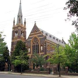
Armidale is a cathedral city, being the seat of the Anglican and Roman Catholic bishops of Armidale. St Peter's Anglican Cathedral, which replaced the original St Peter's Church, was designed by the Canadian architect John Horbury Hunt, who also designed Booloominbah at the University of New England. St Peter's Cathedral opened for worship in 1875 and the tower was added in 1938. The Catholic Cathedral of St Mary and St Joseph was dedicated on 12 December 1919.
The city centre is laid out in a grid of streets. The main street is called Beardy Street, named for two of the founding settlers who had beards.[34] The court house was built in the 1850s and is still a prominent feature of the central district. Much of the rest of the city is residential.
The Australian Wool Fashion Awards, which showcases the use of Merino wool by fashion designers, are hosted by Armidale in March each year. The Autumn Festival is a popular annual event of April in Armidale. The festival features a street parade, stalls and celebrations throughout the city. It is a regular part of the city's attractions, often promoting Armidale's diverse culture (for instance, posters set up by council attempt to attract tourists with the motto "Foodies Thrive in Armidale") and autumn colours. During May the annual New England Wool Expo is staged to display wool fashions, handicrafts, demonstrations, shearing competitions, yard dog trials and demonstrations, a wool bale rolling competition and other activities.
Suburbs
- Acacia Park
- East Armidale
- West Armidale
- Ben Venue
- Bona Vista
- Commissioners Waters
- Dumaresq
- Duval
- Madgwick
- North Hill
- Newling
- Soudan Heights
- South Hill
- St. Patrick's
- The Mission
Sister cities

Education
The city is home to a large number of education facilities, including the Armidale Waldorf School (1985),[35] New England Girls' School (1895), The Armidale School (1894), and the Presbyterian Ladies' College, Armidale (PLC Armidale) (1887), schools of the Australian independent education sector. O'Connor Catholic College (1975) and St Mary's Primary School are systemic Catholic schools. Duval High School (1972) and Armidale High School (1911) were government-funded secondary schools until their closing at the end of 2018. In 2019, the two schools were reborn as one in the form of Armidale Secondary College, which is temporarily located on the campus of the former Duval High School. Approximately 27% of Armidale's total population is in the 10–24-year age group, compared with an equivalent NSW figure of 18%.[33]
University of New England
The university was founded in 1938, at first as a college of the University of Sydney, but then in its own right in 1954. The UNE contributes to Armidale's position as a city of culture and diversity, with a vibrant artistic and cultural element. The university has strong links to the rural community, and undertakes a lot of agricultural research. There is also a high-technology presence, as well as notable humanities teaching. UNE hosts a wide range of courses, and introduced a number of new courses in 2008, including a five-year Bachelor of Medical Science and Doctor of Medicine program as part of a joint medical program with the University of Newcastle.[36] The university is built around the historic mansion Booloominbah, which is now used for administration and houses a restaurant. UNE is one of the city's main employers.
Retail

Armidale is a major regional retail centre, housing three shopping malls:
- Central Armidale. A A$49 million development[37][38] anchored by a Woolworths, Big W and 32 speciality stores.[39][40] It began trading under the name 'Centro' in late November 2007, and was rebranded 'Central' in 2014.
- Armidale Plaza, a A$70 million venture,[37] officially opened an extension, refurbishment and rebranding (formerly Kmart Plaza) in August 2007. Armidale Plaza is anchored by Kmart, Target Country, IGA and 50 specialty stores. Bi-Lo was one of the anchor stores until it closed on 28 February 2010. IGA became an anchor store where it opened there on 8 November 2011.
- The East Mall was constructed in 2002 and houses Coles Supermarket and 15 speciality stores.
Mall

Armidale has a pedestrian mall which stretches over three blocks of Beardy Street in the centre of city. It features many shops and cafés with outdoor eating areas along with some notable architecture, including Tattersalls Hotel, built in the Art Deco style during the 1930s; Armidale Courthouse; the city's main post office; the former Commonwealth Bank and the New England Hotel. The mall was opened in 1973 and was the first of its kind in regional Australia.[41]
Armidale Dumaresq Council has been undertaking major upgrades to the mall since 2003 as part of the Armidale CBD Streetscape Design Project which aims at easing traffic in the city centre by creating an emphasis on the "ring road" around the CBD with the assistance of signage, elevation of roads using paving and the creation of one-way streets.
Media
The city is serviced by one local newspaper, many radio stations including four local outlets, and all major television stations.[42]
Local press
- Armidale Express
- Armidale Express Extra
- Armidale Independent, closed November 2014
Local radio
- TUNE! FM, one of Australia's oldest community radio stations aimed at a youth audience.
- 2AD/FM100.3, a commercial broadcaster owned by the SuperNetwork.
- 2ARM 92.1 FM, a community radio station staffed by volunteers and operating from premises in Kentucky Street with a Permanent Community Broadcasting Licence. See program guide at http://2arm.net.au
- 88.0 is a narrowcast tourist radio station.
- 87.6 Raw FM Australia (Dance Floor Radio Network)
National radio
- Triple J.
- ABC Radio National.
- ABC Classic FM.
- 2KY National Racing Service.
- ABC Local Radio.
Television stations
- Prime7, 7Two, 7mate, 7flix – Seven Network affiliated channels.
- Nine (NBN Television), 9Go!, 9Gem, 9Life – Nine Network owned channels..
- WIN Television, 10 Bold, 10 Peach – Network Ten affiliated channels.
- ABC, ABC Comedy, ABC Me and ABC News, part of the Australian Broadcasting Corporation.
- Special Broadcasting Service, SBS, SBS Viceland, SBS Food and NITV.
Subscription Television services are provided by Foxtel.
Attractions
- Armidale and Region Aboriginal Cultural Centre and Keeping Place
- Oxley Wild Rivers National Park, which includes Dangar Falls and Gorge and Gara Gorge
- Saumarez Homestead
- New England Regional Art Museum
- Cathedral Rock National Park
- Waterfall Way and Wollomombi Falls
- Mount Yarrowyck Aboriginal Rock Art site
- Gemstone fossicking
Notable people
The following notable people were either born in, currently live in or previously resided in Armidale
- Peter Allen, singer and stage performer[43]
- Charles Badham (1884–1943) medical practitioner and public health officer[44]
- Archie Barwick, farmer and WWI sergeant
- Jack Bedson, children's author and poet
- Kate Bell, actress
- Anya Beyersdorf, actress
- Leigh Blackmore, writer and editor
- Florence Turner Blake (1873–1959) artist and benefactor[45]
- Alex Buzo, playwright
- Gilbert Ernest Cory (1906–1977) solicitor and army officer[46]
- Bruce Devlin, professional golfer, sportscaster and golf course designer.
- Edward Doody, Catholic bishop
- Cadel Evans, professional cyclist[47]
- Hugh Gordon, veterinary parasitologist
- Bill Hirschberg (1881–1963), rugby union player
- Anthony Kelly, martial artist
- Sir Frank Kitto, former High Court Judge, former Chancellor of the University of New England
- Anne Plunkett, Australian Ambassador to Ireland; Portugal
- Gayla Reid, writer
- Frank Roberts, boxer
- Joe Roff, rugby union player
- Sir Mark Sheldon (1871–1956) Businessman[48]
- Angelina Sondaq, Miss Indonesia 2001 and politician, was born and educated in Armidale.[49]
- Elzear Torreggiani, Catholic bishop
- Peter Turnbull, WW2 fighter ace
- Margaret Vyner, model and actress
- Don Walker, keyboardist for Cold Chisel
- George Warnecke (1894–1981), journalist, publisher, and founding editor of The Australian Women's Weekly[50]
- Dean Widders, rugby league player
- Sir Thomas George Wilson (1876–1959) Obstetrician and Gynaecologist[51]
- Judith Wright, poet
- Sir Zelman Cowen, 19th Governor-General of Australia, in office from 1977 to 1982, vice-chancellor of the University of New England (1966–1970).
References
- "3218.0 – Regional Population Growth, Australia, 2017-18: Population Estimates by Significant Urban Area, 2008 to 2018". Australian Bureau of Statistics. Australian Bureau of Statistics. 27 March 2019. Retrieved 22 April 2019. Estimated resident population, 30 June 2018.
- Armidale Archived 16 July 2016 at the Wayback Machine Retrieved 23 October 2010
- "Armidale – Fast Facts". SMH Traveller. 13 November 2008. Archived from the original on 3 November 2012. Retrieved 11 February 2009.
- Armidale Air Quality Group
- "Health costs of woodsmoke in Armidale"
- Robinson, D.L.; Monro, J.M.; Campbell, E.A. (2007). "Spatial variability and population exposure to PM2.5 pollution from woodsmoke in a New South Wales country town". Atmospheric Environment. 41: 5464–5478. doi:10.1016/j.atmosenv.2007.01.059.
- "Archived copy". Archived from the original on 24 September 2016. Retrieved 8 February 2016.CS1 maint: archived copy as title (link)"Local ABC Radio Interview Transcript – smoke gets in your eyes and lungs"
- Chen, Deliang; Chen, Hans W. (2013). "Using the Köppen classification to quantify climate variation and change: An example for 1901–2010". Environmental Development. Elsevier. 6: 69–79. doi:10.1016/j.envdev.2013.03.007. Retrieved 12 July 2015.
- "Armidale Airport (AWM)". Climate statistics for Australian locations. Bureau of Meteorology. March 2013. Retrieved 10 March 2013.
- "ARMIDALE (TREE GROUP NURSERY)". Climate statistics for Australian locations. Bureau of Meteorology. June 2018. Retrieved 18 June 2018.
- Peter Burr. "The Big Armidale Hailstorm: Sunday 29th September 1996". Storm News and Chasing. Retrieved 11 June 2007.
- Peter Burr. "Severe Hailstorm at Armidale: Saturday 1st January 2000". Storm News and Chasing. Retrieved 11 June 2007.
- "State of emergency declared in Armidale". ABC News. 22 December 2006. Archived from the original on 22 January 2008.
- "Emergency declared in wake of massive hailstorm". The Sydney Morning Herald. 22 December 2006.
- "Armidale | Fly Corporate". Fly Corporate. Retrieved 1 November 2016.
- Royal Australian Historical Society. (1918), "47 v. : ill. ; 22 cm.", Journal and proceedings, Sydney: The Society, ISSN 1325-9261, nla.obj-595105154, retrieved 9 April 2020 – via Trove
- Premier Postal History. "Post Office List". Premier Postal Auctions. Retrieved 26 May 2011.
- "Armidale Post Office". New South Wales State Heritage Register. Office of Environment and Heritage. Retrieved 12 October 2017.
- Chisholm, Hugh, ed. (1911). . Encyclopædia Britannica. 2 (11th ed.). Cambridge University Press. p. 575.
- "Armidale Post Office". New South Wales State Heritage Register. Office of Environment and Heritage. H01312. Retrieved 18 May 2018.
- "CBA Bank (former)". New South Wales State Heritage Register. Office of Environment and Heritage. H00433. Retrieved 18 May 2018.
- "Railway Turntable". New South Wales State Heritage Register. Office of Environment and Heritage. H01233. Retrieved 18 May 2018.
- "Armidale Railway Station and yard group movable relics". New South Wales State Heritage Register. Office of Environment and Heritage. H01075. Retrieved 18 May 2018.
- "Central Park". New South Wales State Heritage Register. Office of Environment and Heritage. H02019. Retrieved 18 February 2020.
- "St Mary & St Joseph Catholic Cathedral Group". New South Wales State Heritage Register. Office of Environment and Heritage. H01925. Retrieved 18 May 2018.
- "Lands Board Office". New South Wales State Heritage Register. Office of Environment and Heritage. H00963. Retrieved 18 May 2018.
- "Booloominbah". New South Wales State Heritage Register. Office of Environment and Heritage. H01768. Retrieved 18 May 2018.
- "C B Newling Centre". New South Wales State Heritage Register. Office of Environment and Heritage. H01769. Retrieved 18 May 2018.
- "Roseneath". New South Wales State Heritage Register. Office of Environment and Heritage. H00063. Retrieved 18 May 2018.
- "Anglican Cathedral Church of St Peter Apostle and Martyr Precinct". New South Wales State Heritage Register. Office of Environment and Heritage. H01924. Retrieved 18 May 2018.
- "Saumarez Homestead". New South Wales State Heritage Register. Office of Environment and Heritage. H01505. Retrieved 18 May 2018.
- "Hunter River Lancers Training Depot (Place ID 105656)". Australian Heritage Database. Department of the Environment. Retrieved 23 September 2018.
- Australian Bureau of Statistics (27 June 2017). "Armidale". 2016 Census QuickStats. Retrieved 30 November 2017.

- "Armidale". Sydney Morning Herald online travel section. 8 February 2004.
- Waldorf School
- University of New England Archived 8 May 2012 at the Wayback Machine
- "Shopping centres on track for 2007 opening". The Armidale Express. 19 July 2006. Archived from the original on 21 January 2008.
- "Development Overview – Centro Properties Group". 31 December 2007.
- "Centro Armidale nears construction phase". The Armidale Express. 10 May 2006. Archived from the original on 21 January 2008.
- "Read all about your new Centro shopping centre in My Life magazine". Archived from the original on 11 July 2012. Retrieved 14 July 2008.
- "Armidale CBD Master Plan Report" (PDF). Archived from the original (PDF) on 26 August 2006.
- Tamworth TV Guide Archived 20 August 2006 at the Wayback Machine
- Ingall, Jennifer (5 February 2008). "Peter Allen's Armidale". Australian Broadcasting Corporation. Retrieved 29 April 2010.
- Holland, Robert A. B. (2005). "Badham, Charles (1884–1943)". Australian Dictionary of Biography. Australian Dictionary of Biography. Retrieved 30 March 2015.
- Waterhouse, Jill (1993). "Blake, Florence Turner (1873–1959)". Australian Dictionary of Biography. Australian Dictionary of Biography. Retrieved 30 March 2015.
- Grant, Ian (1993). "Cory, Gilbert Ernest (1906–1977)". Australian Dictionary of Biography. Australian Dictionary of Biography. Retrieved 30 March 2015.
- "Cadel Evans Biography". cadelevans.com.au. Archived from the original on 15 May 2010. Retrieved 29 April 2010.
- "Sheldon, Sir Mark (1871–1956)". Australian Dictionary of Biography. 1988.
- "How Angelina went from Sydney to Miss Indonesia to politics to jail". The Sydney Morning Herald. 11 March 2013.
- Griffen-Foley, Bridget (2012). "Warnecke, Glen William ('George')". Australian Dictionary of Biography, Vol. 18. Melbourne University Press. Online version retrieved 24 September 2016.
- "Wilson, Sir Thomas George (1876–1958)". Australian Dictionary of Biography. 2002.
External links
| Wikimedia Commons has media related to Armidale, New South Wales. |
| Wikivoyage has a travel guide for Armidale. |