Angrie
Angrie is a commune in the Maine-et-Loire department in western France.
Angrie | |
|---|---|
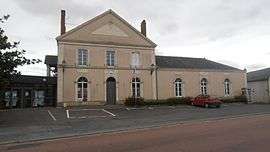 The town hall of Angrie | |
Location of Angrie 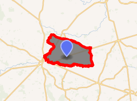
| |
 Angrie  Angrie | |
| Coordinates: 47°34′15″N 0°58′20″W | |
| Country | France |
| Region | Pays de la Loire |
| Department | Maine-et-Loire |
| Arrondissement | Segré |
| Canton | Segré |
| Intercommunality | Anjou Bleu Communauté |
| Government | |
| • Mayor (2014-2020) | Jean-Alain Chevillard |
| Area 1 | 40.93 km2 (15.80 sq mi) |
| Population (2017-01-01)[1] | 949 |
| • Density | 23/km2 (60/sq mi) |
| Time zone | UTC+01:00 (CET) |
| • Summer (DST) | UTC+02:00 (CEST) |
| INSEE/Postal code | 49008 /49440 |
| Elevation | 36–88 m (118–289 ft) (avg. 64 m or 210 ft) |
| 1 French Land Register data, which excludes lakes, ponds, glaciers > 1 km2 (0.386 sq mi or 247 acres) and river estuaries. | |
Population
| Historical population | ||
|---|---|---|
| Year | Pop. | ±% |
| 1793 | 1,173 | — |
| 1800 | 990 | −15.6% |
| 1806 | 945 | −4.5% |
| 1821 | 1,103 | +16.7% |
| 1831 | 1,205 | +9.2% |
| 1836 | 1,163 | −3.5% |
| 1841 | 1,252 | +7.7% |
| 1846 | 1,434 | +14.5% |
| 1851 | 1,486 | +3.6% |
| 1856 | 1,510 | +1.6% |
| 1861 | 1,665 | +10.3% |
| 1866 | 1,901 | +14.2% |
| 1872 | 1,873 | −1.5% |
| 1876 | 1,848 | −1.3% |
| 1881 | 1,865 | +0.9% |
| 1886 | 1,862 | −0.2% |
| 1891 | 1,899 | +2.0% |
| 1896 | 1,703 | −10.3% |
| 1901 | 1,685 | −1.1% |
| 1906 | 1,636 | −2.9% |
| 1911 | 1,607 | −1.8% |
| 1921 | 1,390 | −13.5% |
| 1926 | 1,322 | −4.9% |
| 1931 | 1,309 | −1.0% |
| 1936 | 1,273 | −2.8% |
| 1946 | 1,194 | −6.2% |
| 1954 | 1,169 | −2.1% |
| 1962 | 927 | −20.7% |
| 1968 | 925 | −0.2% |
| 1975 | 787 | −14.9% |
| 1982 | 704 | −10.5% |
| 1990 | 700 | −0.6% |
| 1999 | 678 | −3.1% |
| 2006 | 820 | +20.9% |
| 2009 | 923 | +12.6% |
| 2014 | 957 | +3.7% |
References
- "Populations légales 2017". INSEE. Retrieved 6 January 2020.
| Wikimedia Commons has media related to Angrie. |
| Authority control |
|
|---|
This article is issued from Wikipedia. The text is licensed under Creative Commons - Attribution - Sharealike. Additional terms may apply for the media files.