Al-Darb al-Ahmar
Al-Darb al-Ahmar is a historic neighbourhood in Cairo, Egypt. It is also the name of an administrative district (qism) within the Cairo Governorate that includes most of the neighbourhood. Its name means "the Red Street" in Arabic.
History
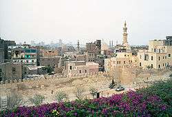
_-_TIMEA.jpg)
The area south of Cairo's city walls, between Bab Zuweila and the Citadel, was initially the site of Fatimid and Ayyubid-era cemeteries.[1] Under the prosperous reign of Sultan al-Nasir Muhammad (between 1293 and 1341) the population of the city reached its peak and the area began to be developed in earnest. The city expanded southwards and many Mamluk elites were eager to build new establishments closer to the Citadel, the seat of the sultan's power. Al-Nasir himself encouraged this development and even built some of the palaces northwest of the Citadel for his amirs (such as the Palace of Amir Qawsun), just as he was building his own palaces inside the Citadel.[2] The Bab al-Wazir Cemetery also developed next to the neighbourhood at this time, just outside the old Ayyubid city walls.[3]
As a result of this period's development, most of the neighbourhood's notable historic monuments date from the 14th century.[1] From the late 14th century onward, however, Cairo suffered from the Black Plague and its population declined and did not recover until centuries later.[4] Nonetheless, the area did develop further during the Ottoman period. The Qasaba of Radwan Bey (now part of the Tentmakers' Street), for example, was a commercial urban complex developed in the 17th century along the old Qasaba road (now al-Mu'izz Street) and partly aimed at promoting urbanization of the area.[1][4] The area received further urbanization impetus during the 19th century when Muhammad 'Ali Pasha again redeveloped the nearby Citadel as a seat of power. He granted various plots of land in al-Darb al-Ahmar to important army officers who were thus encouraged to build in the area.[1][5]
The district was a center of craftsmanship for generations, but in recent years it has suffered from the liberalization of Egypt's economy and the neighbourhood is hampered by poverty.[6] The district also suffered heavy damage during the 1992 Cairo earthquake.
Today the district has about 100,00 residents.[7][6] The weakness of central authority has recently created problems for historic conservation, as many old houses are being demolished and replaced with modern high-rise structures.[8]
Geography and description
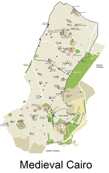
The district historically consists of the area between the Citadel and Bab Zuweila.[1] However, the modern administrative district (qism) of al-Darb al-Ahmar has different borders: it includes the region south of al-Azhar street (in central historic Cairo, within the walled city) and ends slightly north of the Citadel.[9] The district is part of the Cairo Governorate.
The neighbourhood is centered around two or three main streets, one of which is named al-Darb al-Ahmar, giving the district its name. The southern sections of al-Darb al-Ahmar Street officially have different names, however, such as Bab al-Wazir Street (named after a former city gate). Another major street, which branches off al-Darb al-Ahmar street, is Souq al-Silah Street, which was once a market for producers of arms and armor near the Citadel.[1]:86 The modern Muhammad 'Ali Street (Shari'a Muhammad 'Ali) also cuts across the southwestern side of the district.
Demographics
Today the neighbourhood has about 100,00 residents according to some sources,[7][6] though another census-based source puts the population of the modern district at around 60,000.[9] According to a 2010 report[7] on the neighbourhood, the district includes some of the poorest households in Egypt, with unemployment as high as 60% (mostly among women) and a 45% rate of illiteracy. About 83% of the population was born locally.[7]
Present-day conservation efforts
Since around 2000, the area has been the subject of a long-running conservation and restoration program led by the Aga Khan Trust for Culture, aimed at restoring and rehabilitating historic monuments within the urban fabric of the neighbourhood.[10] Monuments that were restored include the Mausoleum complex of Khayrbek and surrounding structures, the Madrasa of Umm al-Sultan Sha'ban, the Mosque of Aslam al-Silahdar, and the Mausoleum of Tarabay al-Sharifi.[11] The development program also involved the creation of al-Azhar Park, one of the few major green spaces in Cairo, which adjoins the neighbourhood today to the east.
Historic monuments in the neighbourhood
Below is a list of some of the notable historic monuments in al-Darb al-Ahmar:
- Qasaba (covered market) of Radwan Bey
- Mosque of al-Salih Tala'i
- Mosque of Qijmas al-Ishaqi
- Mosque of Aslam al-Silahdar
- Mosque of al-Maridani
- Madrasa of Umm Sultan al-Sha'ban
- Bayt al-Razzaz palace
- Mosque of Aqsunqur (Blue Mosque)
- Mausoleum complex of Khayrbek
- Mausoleum of Tarabay al-Sharifi
- Madrasa of Aljay al-Yusufi
- Ayyubid City walls (excavated and restored as part of the development of al-Azhar Park)
- Maristan of al-Mu'ayyad

References
- Williams, Caroline (2018). Islamic Monuments in Cairo: The Practical Guide (7th ed.). Cairo: The American University in Cairo Press.
- "Qasr Amir Qawsun". Archnet. Retrieved 2019-11-04.
- El Kadi, Galila; Bonnamy, Alain (2007). Architecture for the Dead: Cairo's Medieval Necropolis. Cairo: The American University in Cairo Press.
- Raymond, André (1993). Le Caire. Fayard. ISBN 2213029830.
- El Rashidi, Seif. "The History and Fate of al-Darb al-Ahmar". 2004. Cairo: Revitalising a Historic Metropolis. (Stefano Bianca and Philip Jodidio, eds.) Turin: Umberto Allemandi & C. for Aga Khan Trust for Culture, 55-65. (URL: https://archnet.org/publications/4838)
- Wilton-Steer, Harry Johnstone, photography by Christopher (2018-03-21). "Alive with artisans: Cairo's al-Darb al-Ahmar district – a photo essay". The Guardian. ISSN 0261-3077. Retrieved 2019-11-04.
- Morbidoni, Michele (2010). "Cairo, Egypt: The al-Darb al-Ahmar Housing Rehabilitation Programme." Report by United Cities and Local Government (UCLG) on Social Inclusion, Participatory Democracy and Human Rights. URL: https://www.uclg-cisdp.org/sites/default/files/Cairo_2010_en_FINAL.pdf
- "One man's struggle to save Cairo's architectural heritage". World Economic Forum. Retrieved 2019-11-04.
- "Al-Qāhirah (Governorate, Egypt) - Population Statistics, Charts, Map and Location". www.citypopulation.de. Retrieved 2019-11-05.
- "Al-Darb Al-Ahmar District Mosques". World Monuments Fund. Retrieved 2019-11-04.
- "Darb al-Ahmar Conservation and Revitalisation". Archnet. Retrieved 2019-11-04.
Districts and suburbs of Greater Cairo-Giza | ||||||||||
|---|---|---|---|---|---|---|---|---|---|---|
| Cairo Governorate |
|   | ||||||||
| Giza Governorate |
| |||||||||
| Qalyubia Governorate |
| |||||||||