Bayn al-Qasrayn
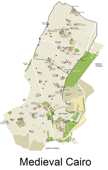
Bayn al-Qasrayn is the district and plaza between two former palace complexes constructed in the 10th century by the Fatimid dynasty in medieval Islamic Cairo, within present day Cairo, Egypt. It was an original element in the Fatimid Caliphate's plan for a new palace-city, named al-Qahirah (today's "Cairo"), and later became the site of many monumental buildings constructed in the Ayyubid, Mamluk, and Ottoman periods, even up to the 19th century. Many of these structures from different periods survive in the area today, located along what is now called al-Mu'izz Street.
History
Fatimid founding
The Fatimids conquered Egypt in 969 C.E with a North African Kutama army under the command of the general, Jawhar al-Siqilli. In 970, Jawhar was responsible for planning, founding, and constructing a new city to serve as the residence and center of power for the Fatimid Caliphs. The city was named al-Mu'izziyya al-Qahirah, the "Victorious City of al-Mu'izz", later simply called "al-Qahira", which gave us the modern name of Cairo.[1]:80 The city was located northeast of Fustat, the existing capital and main city of Egypt. Jawhar organized the city so that the caliphal palace complex was at its center.
The palace complex consisted of two main parts: the Great Eastern Palace, the first to be built in 970 by Jawhar for the arrival of the triumphant Caliph al-Mu'izz, and the Western Palace, which was added under his successor al-'Aziz (ruled 975-996).[1]:96 The two palaces faced each other across an open square or plaza which became known as "Bayn al-Qasrayn" (meaning "Between the Two Palaces"), on a pattern repeated from the original Fatimid royal city at al-Mahdia, Tunisia.[1][2] This square had great public and symbolic significance. The official entrance to the Great Eastern Palace, known as Bab al-Dhahab ("The Golden Gate") was located here and led to the "Golden Hall" where the Caliph held his daily audience.[1] The square was also the site of various ceremonies related to the dynasty.
Ayyubid and Mamluk development
.jpg)
Over the subsequent centuries, Cairo developed into a full-scale urban center. After the end of the Fatimid Caliphate in the 12th century, the Ayyubid sultans and their Mamluk successors, who were Sunni Muslims eager to erase the influence of the Shi'a Muslim Fatimids, progressively demolished and replaced the great Fatimid palaces with their own buildings. The al-Salihiyya Madrasa, built by al-Salih Ayyub, was one of the first such major constructions, and his mausoleum (built after his death by Shajarr ad-Durr), is the first post-Fatimid mausoleum to be erected in a public location along Cairo's main streets; a practice that would become common thereafter.
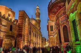
The ceremonial square consequently shrank and eventually became merely another stretch of the Qasabah, the main north-south street of Cairo. Nonetheless, due to its central and symbolic location, the Bayn al-Qasrayn area remained a privileged site in Cairo, and many major mosques, mausoleums, and mansions of rulers and elites were built along the former plaza, particularly in the Mamluk era. Structures such as Sultan Qalawun's mausoleum, hospital, and madrasa, a major monument of its time, not only made use of the location but also discretely incorporated parts of the old Fatimid palaces into its construction.[3] Ibn Batutah, who visited in 1326, reinforced this concept and commented that the space of Bayn al-Qasrayn was, “beyond one’s ability to describe.”[4]
Urban context: the Qasabah Street
The main north-south street of Cairo which passed through Bayn al-Qasrayn, became known as the "Qasabah", the city's main street or avenue.[Note 1] Today this street is known as Al-Mu'izz Street.
This was the main commercial axis of the city, where the most important economic activities were centered.[5] Shops along here included book dealers, spice and nut suppliers, saddle makers, and cloth merchants who sold their goods to the people of Cairo and to other visitors.[6] The Egyptian historian Al-Maqrizi counted 12,000 shops on the Qasabah street alone.[7] Even after the Fatimid era, this avenue was the focus of many civic or religious monuments built by subsequent rulers and governors up to the 19th century, including many major mosques and mausoleums.[5][3]
The Qasabah street spread both north and south from the original Bayn al-Qasrayn into a mile-long street which extended from the northern gate of the city (Bab al-Futuh) to the southern gate (Bab Zuweila).[8] As Cairo expanded further outside the original Fatimid walled city, development of the Qasaba street extended to the road leading south from the city and reached as far as the Qarafa necropolis.[3]
List of historic monuments at Bayn al-Qasrayn today
While Bayn al-Qasrayn is not a strictly defined area today, the following monuments occupy the former site of the two great Fatimid Palaces, roughly in order from south to north.[5][3] (For a list of all the monuments along the full length of the Qasabah street, see: al-Muizz street.) The prominence of structures originating from royal patronage is an indication of the location's historical prestige.
- Madrasa and mausoleum of Sultan al-Salih Ayyub
- Madrasa of Sultan Baybars (the earliest Mamluk monument, but only a fragment of it remains today)[3]
- Funerary complex (mausoleum, madrasa, and hospital) of Sultan Qalawun (still contains some remnants of the western Fatimid palace)[3]
- Funerary complex (mausoleum and madrasa) of Sultan al-Nasir Muhammad
- Funerary complex (mausoleum and khanqah) of Sultan Barquq
- Sabil and school of Isma'il Pasha (19th century)
- Madrasa of Sultan al-Kamil Ayyub (the earliest post-Fatimid monument)[3]
- Hammam of Sultan Inal
- Palace of Amir Bashtak
- Sabil-kuttab of Abd al-Rahman Katkhuda
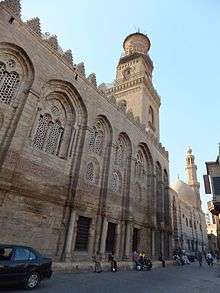
- al-Aqmar Mosque (the only remaining Fatimid monument)[3]
Notes
- The Arabic word "qasabah" (Arabic: قَـصْـبَـة), often spelled "kasbah" elsewhere, has various related meanings, in this case referring to the central part of the city.
References
- Brett, Michael (2017). The Fatimid Empire. Edinburgh: Edinbugh University Press.
- Çelik, Zeynep, Diane G. Favro, and Richard Ingersoll, eds. Streets: Critical Perspectives on Public Space. Berkeley: University of California Press, 1994, p. 72
- Williams, Caroline (2018). Islamic Monuments in Cairo: The Practical Guide (7th ed.). Cairo: The American University in Cairo Press.
- M. ibn Batutah, The Travels of Ibn Batutah (1326), H.A.R Gibb, trans., volI (Cambridge, 1958), 4.
- Raymond, André (1993). Le Caire. Fayard.
- G. Wiett, Cairo: City of Art and Commerce (Norman, 1964), 99
- Max Rodenbeck, Cairo: The City Victorious. Alfred Knopf; New York, 1999. p82
- Çelik, Zeynep, Diane G. Favro, and Richard Ingersoll, eds. Streets: Critical Perspectives on Public Space. Berkeley: University of California Press, 1994, p. 77