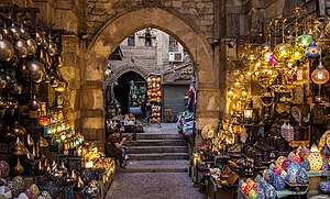
Khan el-Khalili
Khan el-Khalili (Arabic: خان الخليلي) is a famous bazaar and souq (or souk) in the historic center of Cairo, Egypt. Established as a center of trade in the Mamluk era and named for one of its several historic caravanserais, the bazaar district has since become one of Cairo's main attractions for tourists and Egyptians alike. It is also home to many Egyptian artisans and workshops involved in the production of traditional crafts and souvenirs.
| Khan el-Khalili | |
|---|---|
| Native name Arabic: خان الخليلي | |
 Bab al-Ghuri and shops in the souq. | |
| Type | Bazaar, Souq |
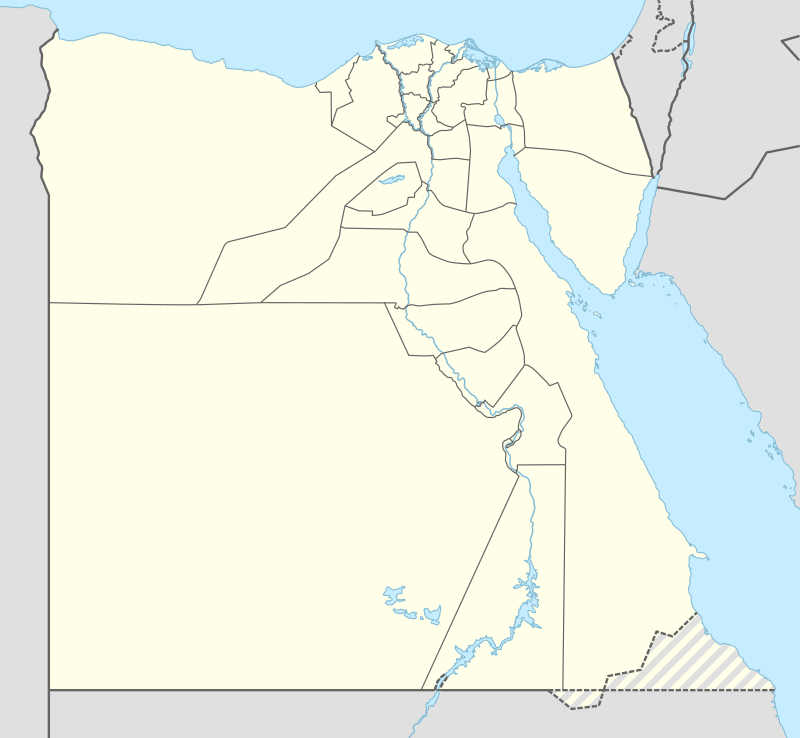
| Location | Cairo, Egypt |
| Coordinates | 30°02′51″N 31°15′44″E |
| Founded | Establishment of the first "Khan al-Khalili" between 1382-1389 (first reign of Sultan Barquq) |
| Founder | Jaharkas al-Khalili |
| Architectural style(s) | Islamic architecture, Mamluk architecture |
 Location of Khan el-Khalili in Egypt | |
| This article is part of a series on |
| Life in Egypt |
|---|
 |
| Culture |
|
| Society |
|
| Politics |
|
| Economy |
|
Egypt portal |
History

The site of Khan el-Khalili in Fatimid times (10th-12th centuries)
Cairo itself was originally founded in 969 CE as a royal city and capital for the Fatimid Caliphate, an empire which by then covered much of North Africa, parts of the Levant and Hijaz. Gawhar al-Siqilli, the general who had just conquered Egypt for the Fatimids, was ordered to construct a great palace complex to house the caliphs, their household, and the state's institutions.[1] Two palaces were eventually completed: an eastern one (the largest of the two) and a western one, between which was an important plaza known as Bayn al-Qasrayn ("Between the Two Palaces"). The site of Khan el-Khalili today was originally the southern end of the eastern Great Fatimid Palace, as well as the location of the burial site of the Fatimid caliphs: a mausoleum known as Turbat az-Za'faraan ("the Saffron Tomb").[2][3][1]:57 Also located here was a lesser palace known as al-Qasr al-Nafi'i (today the site of the 19th-century Wikala of Sulayman Agha al-Silahdar).[4]
Under the Fatimids, Cairo was a palace-city which was closed to the common people and inhabited only by the Caliph's family, state officials, army regiments, and other people necessary to the operation of the regime and its city.[1] The first attempts to open the city to merchants and other outsiders took place in the later Fatimid period, on the initiative of powerful viziers.[4] Between 1087 and 1092, Badr al-Gamali, the vizier under Caliph al-Mustansir, undertook the task of enlarging the city and building the stone walls and gates that still partly exist today. At the same time he also opened the city to the common people, but the decision was quickly reversed. Between 1121 and 1125, al-Ma'mun al-Bata'ihi, vizier under Caliph al-Amir, undertook many reforms and construction projects, including the creation of a mint, the Dar al-Darb, and of a customs house for foreign merchants, known as the Dar al-Wikala, at a central location not far from the current site of the Madrasa of al-Ashraf Barsbay (15th century). This introduced foreign trade into the heart of the city for the first time.[4]:199 (vol. II)
The opening of Cairo and its development as an economic center (12th-14th centuries)
Cairo was only definitively opened to all people under the rule of Salah ad-Din (Saladin), who dismantled the Fatimid Caliphate in 1171 and embarked on the construction of a new fortified Citadel (the current Citadel of Cairo) further south, outside the walled city, that would house Egypt's rulers and state administration.[1] The old Fatimid palaces in the city were opened up to redevelopment. This ended Cairo's status as an exclusive palace-city and started a process by which the city became an economic center inhabited by everyday Egyptians and frequented by foreign travelers.[4] At the same time the nearby port city (and former capital) Fustat, until then the economic hub of Egypt, was in a slow decline, further paving the way for Cairo's ascendance.[4][1]
The main axis of Cairo was the central north-to-south street known as the Qasaba (now known as al-Muizz street), which ran between the gates of Bab al-Futuh and Bab Zuweila and passed through Bayn al-Qasrayn. Under the Ayyubids and the later Mamluks, this avenue became a privileged site for the construction of religious complexes, royal mausoleums, and commercial establishments, usually sponsored by the sultan or the highest members of the ruling class. This is also where the major souqs of Cairo developed, forming its main economic zone of international trade and commercial activity thereafter.[1][5][4]
An important factor in the development of Cairo's economic center was the growing number of waqf institutions, especially during the Mamluk period. Waqfs were charitable trusts under Islamic law which set out the function, operations, and funding sources of the many religious/civic establishments built by the ruling elite.[6] These funding sources often included the revenues of designated shops or other commercial establishments. Among the early and important examples of this institution in Cairo's center was the complex of Sultan Qalawun (which included a madrasa, hospital, and mausoleum), built in 1284-85. A part of the complex's revenues came from a nearby qaysariyya (a bazaar or market complex made up of rows of shops) built in front of the Ayyubid-era madrasa of al-Salih (whose minaret is still visible today behind these rows of shops). This qaysariyya was thus an early prominent example of the purpose-built commercial structures erected in Cairo under the Mamluks as part of a waqf. In this case, the complex fronted the main street on one side while other shops were reached by an inner alley.[4]
The foundation of the Khan al-Khalili during the Mamluk period (14th-15th centuries)
.jpg)
Over many years, space along the Qasaba avenue steadily narrowed as new constructions encroached on it and open spaces disappeared. As the main street became saturated with shops and space for further development there ran out, new commercial structures were instead built further east, close to al-Azhar Mosque and to the shrine of al-Hussein, where some space was still available.[4] Furthermore, instead of mobile market stalls that were assembled in open spaces, the city's souq areas were progressively replaced by fixed stone structures with spaces for shops. This was in part a consequence of the authorities wishing to impose greater order on commercial activities; fixed structures could be counted, taxed, and regulated more easily than makeshift market stalls that could come and go.[4] During the Mamluk period, as the city became denser and space ran out, builders preferred to build multi-storied structures known as a khan (Arabic: خان) or a wikala (Arabic: وكالة), both terms for urban variants of a caravanserai (an inn for merchants). These types of buildings were centered around an inner peristyle courtyard where merchants could store their goods, with upper levels used as living quarters. The street facades of these buildings generally had spaces for shops at ground level, and in this way a commercial zone could extend around and between multiple khans.[4][5]
By the time of Sultan Barquq, the first Circassian (or Burji) Mamluk Sultan, in the late 14th century, Egypt had been significantly affected by the ravages of the Black Death but continued to be the center of great economic activity, with many commercial and religious buildings still being constructed at this time.[1]:147 During Barquq's first reign (1382-1389) his Master of the Stables (amir akhur), Jaharkas al-Khalili, demolished the Fatimid mausoleum (the Turbat az-Za'faraan) to erect a large khan at the heart of the city, which became known as Khan al-Khalili.[5] The name later came to denote the entire district. Jaharkas reportedly disposed of the bones of the Fatimid royal family by throwing them into the rubbish hills east of the city.[1]:57
Later Mamluk elites also built commercial structures in the vicinity and beyond. In Sultan Qaytbay's time, one of his amirs, Yashbak min Mahdi, built the Rab' al-Badistan (an apartment complex for renters) just across from the Khan al-Khalili.[5] Qaytbay himself built the Wikala of Sultan Qaytbay further east, near al-Azhar Mosque. By the late 15th century, the district around Khan el-Khalili had become the major center of foreign trade, including the sale of slaves and precious stones.[6]:62
Re-development by Sultan al-Ghuri (early 16th century)
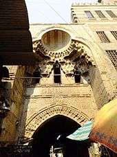
In the early 16th century, Sultan al-Ghuri, Egypt's last effective Mamluk sultan (ruled 1501-1516), modified the layout of the whole district through a major campaign of demolition and new construction. In addition to building his own religious and funerary complex and a large Wikala by his own name nearby, he demolished the original khan built by al-Khalili and rebuilt it in 1511. It became known as the Khan al-Fisqiya ("Khan of the Fountain") for centuries, until later being known as the Wikala al-Qutn ("Wikala of Cotton").[4] Al-Ghuri also reconfigured the adjacent area into a souq with monumental gates known as the Suq al-Nabulsi. He also tried to impose a more regular grid-like plan on the wider surrounding district.[1]:179 Along with the stone gates, this sort of complex resembled what in Ottoman cities was known as a bedestan: a central bazaar where the most precious goods were sold, which often had roofed streets and was protected by locked gates at night (and which was also equivalent in some ways to a qaysariyya). It's possible that this was done in imitation of similar commercial complexes in major Ottoman cities, at a time when the Ottoman Empire was the major rival of the Egyptian Mamluk state and when Turkish merchants were probably increasingly prominent in Cairo.[1]:179
From al-Ghuri's time, what remains today is the Suq al-Nabulsi and its two ornate stone gates, as well as the entrance facade and gate of the Wikala al-Qutn which replaced the original Khan al-Khalili. All are located along the street known as Sikkat al-Badistan. The monumental gate to the west was originally known as Bab al-Silsila, but is known today as Bab al-Badistan, while the eastern gate, across from the Wikala al-Qutn's entrance, was originally known as Bab al-Nuhhas but is also known now as Bab al-Ghuri.[4][5]
By the end of the Mamluk period in the early 16th century, there were 21 khans/wikalas in the district.[4]
Later history (16th century and after)
.jpg)
From the medieval period onward, the Khan al-Khalili area was made up of several major khans/wikalas grouped together, with souq streets existing between them.[7] From al-Ghuri's reign onward, the district became associated with Turkish merchants, and during the Ottoman period the Turkish community of Cairo was centered there.[1] In particular, the Khan al-Fisqiya (or Wikala al-Qutn), which replaced the original Khan al-Khalili structure, was inhabited by Turkish merchants.[4]
During the Ottoman period, the prosperity of Cairo's souqs waxed and waned in accordance with local political and international economic conditions. While Cairo was no longer an imperial capital, it nonetheless played a highly important role in the trade networks of the Ottoman Empire. New khans/wikalas continued to be built. Unlike the previous Mamluk period, the construction of new commercial buildings began to shift to the west of the Qasaba avenue (al-Muizz street) – the only area where there was still space to build.[4]:71 New constructions were relatively rare in the 16th century, but became more common again in the 17th century. Many old buildings were also restored, altered, or rebuilt, especially in the 18th century. While new religious complexes were rarely built (in contrast with the Mamluk period), many small mosques or prayer areas were installed inside existing khans/wikalas.[4]:77 By the end of the 18th century (just before Napoleon's invasion), some 39 khans/wikalas existed in the area of Khan al-Khalili and its adjoining districts.[4]:70 One late example of a large wikala/khan built in the heart of the Khan al-Khalili is the Wikala of Sulayman Agha al-Silahdar (or Wikala al-Silahdar), built in 1837 to replace a ruined Mamluk-era khan and still partially standing today, directly across from the Bab al-Ghuri.[5]
The district underwent significant modifications and re-developments again in the 19th and 20th centuries, alongside major developments in the urban fabric of modern Cairo to the west. Al-Muski Street, a popular market street today, was created by cutting across the urban fabric of the old city to create a street roughly perpendicular to al-Muizz street (the old Qasaba avenue), running from al-Hussein Square in the east to Midan 'Ataba ('Ataba Square) in modern downtown Cairo to the west.[8] Among other important re-developments was the construction of about two dozen new residential blocs with ground-level shops in the eastern sector of the souq, initiated by the princess Shawikar in the late 1930s, which are now some of the areas most frequented by tourists.[7][4]:225

Today
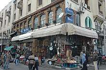
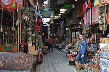
The Khan el-Khalili today is occupied by local merchants and traders, and is significantly geared towards tourists where it is considered as one of the most popular souqs in the region. Shops typically sell souvenirs, antiques and jewelry, but the adjoining goldsmiths' souq, for example, is still important for locals.[5][9]:81 Although less widespread than in earlier days, many craftsmen' workshops continue to operate within the bazaar (usually in the courtyards or upper floors of buildings) or in the surrounding districts, manufacturing some of the products sold here or exported elsewhere.[7]
In addition to shops, there are several coffeehouses (مقهى maqha ), restaurants, and street food vendors distributed throughout the market. The coffeeshops are generally small and quite traditional, serving Arabic coffee and usually offering shisha. One of the oldest and most famous coffeehouses is El Fishawi's, established in 1773.[9]:109
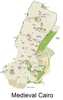
The Khan al-Khalili proper is bounded by al-Muizz street to the west, al-Muski Street to the south, and the Mosque/shrine of al-Hussein (and its adjoining square) to the east, with its northern boundary less clear. However, in reality the souq/bazaar area spreads beyond these limits and is closely integrated into the surrounding districts.[7] For example, al-Muski street, which runs perpendicular to al-Muizz street and cuts across the south end of Khan al-Khalili, is a major souq street frequented mostly by locals for much of its length.[8]
In addition to the important Mosque and shrine of al-Hussein, Al-Azhar University and, with it, the Al-Azhar Mosque, are also nearby. The monumental area of Bayn al-Qasrayn is also just northwest of the district, and some of its historic Islamic buildings were once maintained with the help of revenues from designated shops and commercial buildings in the area.[4][6]
In literature
Naguib Mahfouz's novel Midaq Alley (1947) is set in an alley in Khan el-Khalili.
Pivotal events of Neil Stephenson's novel The Confusion (2004), which is the second book of his The Baroque Cycle series, are set in the caravanserai within Khan el-Khalili.
Terrorist attacks
The market was a target of terrorism during the spate of attacks in Cairo in April 2005. The suicide attack in the market, on April 7, killed 21 people (eleven Egyptians, two French tourists, one American, and seven foreigners of unidentified origin). It was the first attack in the series; this attack drove away tourists from Egypt in general and Khan el-Khalili in particular for some time.
The market was again a target of terrorism on 22 February 2009. In this attack a 17-year-old French girl was killed and 22 people were injured.
References
| Wikimedia Commons has media related to Khan el-Khalili. |
- Raymond, André. 1993. Le Caire. Fayard.
- Lev, Y. 2001. "Aspects of the Egyptian Society in the Fatimid Period". In Vermeulen, Urbain & J. van Steenbergen (eds.). Egypt and Syria in the Fatimid, Ayyubid, and Mamluk Eras III: Proceedings of the 6th, 7th and 8th International Colloquium Organized at the Katholieke Universiteit Leuven in May 1997, 1998, and 1999. Peeters Publishers. p. 20.
- Discover Islamic Art
- Denoix, Sylvie; Depaule, Jean-Charles; Tuchscherer, Michel, eds. (1999). Le Khan al-Khalili et ses environs: Un centre commercial et artisanal au Caire du XIIIe au XXe siècle. Cairo: Institut français d'archéologie orientale.
- Williams, Caroline. 2018 (7th ed.). Islamic Monuments in Cairo: The Practical Guide. Cairo: American University in Cairo Press.
- Behrens-Abouseif, Doris. 2007. Cairo of the Mamluks: A History of Architecture and its Culture. Cairo: The American University in Cairo Press.
- Madoeuf, Anna (2011). "Souk d'aujourd'hui et bazar oriental: Le Khan al-Khalili au Caire" [Today's souk and oriental bazaar: the Khân al-Khalîlî in Cairo]. Géographie et cultures. 77.
- "Sharia Al Muski | Cairo, Egypt Attractions". www.lonelyplanet.com. Retrieved 2019-10-31.
- O'Neill, Zora et al. 2012. Lonely Planet: Egypt (11th edition).