52nd parallel north

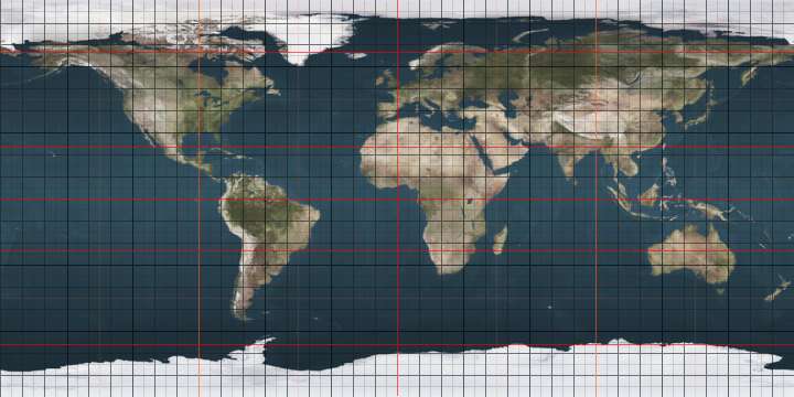
The 52nd parallel north is a circle of latitude that is 52 degrees north of the Earth's equatorial plane. It crosses Europe, Asia, the Pacific Ocean, North America, and the Atlantic Ocean.

52°
52nd parallel north
In Canada, the 52nd parallel north defines part of the border between Quebec and Newfoundland and Labrador (line A), though Quebec maintains a dormant claim to some of the territory to the north of the parallel (line B).

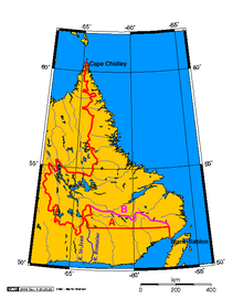
In Canada, part of the legally defined border between Quebec and Newfoundland and Labrador is defined by the parallel, though Quebec maintains a dormant claim to some of the territory north of this line.[1]

The catchment area of London, the capital city of England and the United Kingdom, can be broadly defined by the 51st and 52nd parallels.

At this latitude the sun is visible for 16 hours, 44 minutes during the summer solstice and 7 hours, 45 minutes during the winter solstice.[2]

Around the world

Starting at the Prime Meridian (just west of the village of Barkway in Hertfordshire, England) and heading eastwards, the parallel 52° north passes through:

Co-ordinates Country, territory or sea Notes
52°0′N 0°0′E  United Kingdom England - passing just south of Ipswich
52°0′N 1°25′E North Sea
52°0′N 4°8′E  Netherlands Provinces of South Holland, Utrecht and Gelderland, including directly through the city of Delft[3]
52°0′N 6°48′E  Germany States of North Rhine-Westphalia, Lower Saxony, Saxony-Anhalt and Brandenburg
52°0′N 14°43′E  Poland passing just north of Zielona Góra, and through Biała Podlaska Airport
52°0′N 23°42′E  Belarus
52°0′N 30°54′E  Ukraine Chernihiv Oblast
Sumy Oblast — passing just north of Shostka
52°0′N 34°6′E  Russia
52°0′N 60°9′E  Kazakhstan
52°0′N 79°7′E  Russia
52°0′N 98°49′E  Mongolia
52°0′N 99°17′E  Russia Passing through Lake Baikal
52°0′N 120°42′E  People's Republic of China Inner Mongolia
Heilongjiang
52°0′N 126°27′E  Russia
52°0′N 141°20′E Strait of Tartary
52°0′N 141°40′E  Russia Island of Sakhalin
52°0′N 143°10′E Sea of Okhotsk
52°0′N 156°29′E  Russia Kamchatka Peninsula
52°0′N 158°17′E Pacific Ocean
52°0′N 177°30′E  United States Alaska - Kiska Island
52°0′N 177°33′E Bering Sea
52°0′N 178°6′E  United States Alaska - Segula Island
52°0′N 178°11′E Bering Sea Passing just north of Khvostof Island, Davidof Island and Little Sitkin Island, Alaska,  United States
52°0′N 179°34′E  United States Alaska - Semisopochnoi Island
52°0′N 179°43′E Bering Sea Passing just north of Tanaga Island and Kanaga Island, Alaska,  United States
52°0′N 176°35′W  United States Alaska - Adak Island
52°0′N 176°33′W Bering Sea
52°0′N 176°9′W  United States Alaska - Great Sitkin Island
52°0′N 176°3′W Bering Sea Passing just north of Igitkin Island, Tagalak Island and Oglodak Island, Alaska,  United States
52°0′N 175°22′W Pacific Ocean Passing just south of Atka Island and Amlia Island, Alaska,  United States
52°0′N 131°6′W  Canada British Columbia - Kunghit Island
52°0′N 131°2′W Pacific Ocean Queen Charlotte Sound
52°0′N 128°13′W  Canada British Columbia - Hunter Island, King Island and the mainland
Alberta
Saskatchewan
Manitoba - including Lake Winnipegosis and Lake Winnipeg
Ontario
52°0′N 80°59′W James Bay
52°0′N 79°39′W  Canada Nunavut - Charlton Island and Carey Island
52°0′N 79°12′W James Bay
52°0′N 78°42′W  Canada Quebec
Newfoundland and Labrador
Quebec
Quebec / Newfoundland and Labrador border (disputed by Quebec)[1]
Newfoundland and Labrador
52°0′N 55°52′W Atlantic Ocean Strait of Belle Isle
52°0′N 55°18′W  Canada Newfoundland and Labrador - Belle Isle
52°0′N 55°16′W Atlantic Ocean
52°0′N 10°13′W  Ireland
52°0′N 7°35′W St George's Channel
52°0′N 5°5′W  United Kingdom Wales
England - passing between Bletchley and Milton Keynes at 0° 44′ W

See also

References

  1. Frank Jacobs (2012-07-10). "Oh, (No) Canada!". Opinionator: Borderlines. The New York Times. Retrieved 2012-09-23.
  2. http://aa.usno.navy.mil/data/docs/Dur_OneYear.php
  3. "52° North: a tangible timeline". TU Delft. Retrieved 2019-05-29.
This article is issued from Wikipedia. The text is licensed under Creative Commons - Attribution - Sharealike. Additional terms may apply for the media files.