İspir
İspir (Armenian: Սպեր, Sper; Georgian: სპერი, Speri) is a town and district of Erzurum Province in the Eastern Anatolia region of Turkey, on the Çoruh River. The mayor is Osman Çakır (AKP). The district has a population of 30,260 while the town has a population of 11,789.
İspir | |
|---|---|
 Ispir castle and the historic citadel mosque. | |
 İspir | |
| Coordinates: 40°29′01″N 40°59′43″E | |
| Country | Turkey |
| Province | Erzurum |
| Government | |
| • Mayor | Osman Çakır (AKP) |
| • Kaymakam | Hüseyin Engin Sarıibrahim |
| Area | |
| • District | 2,012.46 km2 (777.02 sq mi) |
| Population (2012)[2] | |
| • Urban | 6,570 |
| • District | 16,338 |
| • District density | 8.1/km2 (21/sq mi) |
| Post code | 25900 |
| Website | www.ispir.bel.tr |
History
İspir is known from the 3rd millennium BC. Ancient kingdom of Hayasa-Azzi (2nd millennium BC), which was the forerunner of Armenian statehood located in the upper reaches of the rivers Euphrates and Chorokh (included Sper). About 600 years (since the 2nd century BC to 5th century AD) this region was a part of a province of the Greater Armenia - Bardzr Ayk (Upper Armenia). The name Sper is thought by some to be derived from Saspers,[3] a tribe mentioned by Xenophon;[4]
The illustrious dynasty of the Bagrationi originated in the most ancient Georgian district – Speri (today İspir).[5] Through their farsighted, flexible policies, the Bagrationi achieved great influence from the sixth through eighth centuries. One of their branches moved out to Armenia, the other to Georgian Kingdom of Iberia, and both won for themselves the dominant position among the other rulers of Transcaucasia.[6]
In the 4th-3rd centuries BC Sper was organized into a province of the Iberian Kingdom as noted by Strabo. Alexander the Great sent one of his generals Menon to conquer Sper, but Menon and his forces were defeated and killed. After this, in 2nd century BC - 5th century AD Sper was a land of Greater Armenia and was a part of Armenian province - Upper Armenia. After this, Sper was an Armenian Bagratid domain in the 4th - 6th centuries, a domain whose territory also comprised the Bayburt plain until that was lost to the Byzantines (perhaps in 387).[4]
In the 7th century it passed to the Arab Caliphate; in 885 Bagratuni Kingdom of Armenia. Under the medieval Kingdom of Armenia, it was part of the province of Upper Armenia and was famous for its gold mines. In the 11th century it was conquered by the Seljuqs. Ispir was under the control of the Saltukids till 1124[7] when the Georgians took over power, governed by Zakare and Ivane Zakarids as a fief. It was recaptured by Mughith ad Din Tughrul, son of the Seljuk sultan Kilij Arslan II, sometime between 1201 and 1225.[7] He built a mosque in the citadel which still survives.[7] It was conquered in 1242 by the Mongols; was regained by Georgian Kingdom during the reign of George V the Brilliant (1314–1346), it remained part of the Kingdom before its disintegration, which then passed into the hands of Georgian Atabegs belonging to the House of Jaqeli; it was conquered in 1502 by Persia and was probably in 1515[7] taken by the Ottoman Empire from the Georgian ruler of Samtskhe.[7]
The valley of Ispir was almost completely Armenian Christian in the early 16th century.[7] In the 1500s Turkish troops violently imposed taxes in Bayburt, Ispir, Yusufeli, and Erzincan and forcibly converted 50,000 Armenians to Islam and massacred 10,000~. In 1723 the Ottomans burned down 100 Armenian villages in Ispir and forced many to convert to Islam[8], periodic forced conversions and massacres of Armenians in the region led to Turkification of Ispir, Many Ispir Armenian migrated to Javakh in 1823 to escape persecution. by the 1900s only the region of Khodorjur(Sirakonak) retained a homogeneous Armenian Christian population who belonged to the Armenian Catholic church[9]. Until the 1800s the Islamized Armenians still retained much of Armenian culture and In some villages the Armenian language, but gradually lost those traditions by the 20th century and became completely Turkified. The Armenian population was deported and massacred in 1915. The town was occupied in 1916 by the Russians during World War I and recaptured by the Turks in 1918.
Historic sights in the town are the citadel, a mosque and church in the citadel (probably 13th century), the originally 13th century Çarsi mosque today's building being a recent structure.[7] The Sultan Melik mosque and Madrasa built in the 13th century, the Madrasa of Kadizade Mehmet built in 1725/26, Kadizade was the Mufti of Erzurum from 1744 to 1759 and his father was the Qadi of Ispir.[7] There is also a tomb with a graveyard containing some Ottoman tombstones.[7]
Climate
The climate is described as Humid Continental by the Köppen Climate System, abbreviated as Dfb.[10]
References
- "Area of regions (including lakes), km²". Regional Statistics Database. Turkish Statistical Institute. 2002. Retrieved 2013-03-05.
- "Population of province/district centers and towns/villages by districts - 2012". Address Based Population Registration System (ABPRS) Database. Turkish Statistical Institute. Retrieved 2013-02-27.
- Donald Rayfield. Edge of Empires: A History of Georgia Reaktion Books, 2013 ISBN 978-1780230702 p 18
- T. A. Sinclair, "Eastern Turkey an Architectural and Archaeological Survey", Volume 2, 1989, p272
- Centered on the modern-day district of İspir, northeastern Turkey, this province is sometimes thought to have been the cradle of the Georgian people (Suny [1994], p. 11)., It lay in what is frequently referred to as the Armeno-Georgian marchlands where the two communities coexisted and intermingled for several centuries, but the Georgian Speri and the Armenian Sper may not always be absolutely identical (cf. Tayk and Tao, Rapp [2003], p. 14).
- Berdzenishvili et al., История Грузии, p. 129, cited in: Suny (1994), p. 349
- Sinclair, T.A. (1989). Eastern Turkey: An Architectural & Archaeological Survey, Volume I. Pindar Press. pp. 265–266-267–281-283–289-290. ISBN 9780907132325.
- http://www.fundamentalarmenology.am/datas/pdfs/292.pdf
- Ատրպետ, Ճորոխի աւազանը, Երևան, 1934, էջ. 110. Մատենադարան, ձեռ. No. 6332, p. 552:
- "Ispir, Turkey Köppen Climate Classification (Weatherbase)". Weatherbase. Retrieved 25 January 2015.
- Prothero, W.G. (1920). Armenia and Kurdistan. London: H.M. Stationery Office. p. 72.
External links
İspir in Erzurum Province of Turkey | |||||||||||||||||||||||||||
|---|---|---|---|---|---|---|---|---|---|---|---|---|---|---|---|---|---|---|---|---|---|---|---|---|---|---|---|
| Districts | 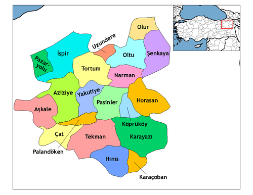 Districts of Erzurum | ||||||||||||||||||||||||||
| |||||||||||||||||||||||||||
Metropolitan municipalities are bolded. | |||||||||||||||||||||||||||