Yongsan District
| Yongsan 용산구 | |
|---|---|
| Autonomous District | |
| 용산구 · 龍山區 | |
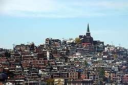 A hill in Haebangchon, a neighborhood in Yongsan | |
 Location of Yongsan-gu in Seoul | |
| Country | South Korea |
| Region | Sudogwon |
| Special City | Seoul |
| Administrative dong | 19 |
| Area | |
| • Total | 21.87 km2 (8.44 sq mi) |
| Population (2010[1]) | |
| • Total | 227,400 |
| • Density | 10,000/km2 (27,000/sq mi) |
| Time zone | UTC+9 (Korea Standard Time) |
| Postal code | 04300 ~ 04499 |
| Area code(s) | +82-2-7xx |
| Website | Yongsan-gu official website |
Yongsan District (Yongsan-gu) is a district of Seoul, South Korea. Its name means "Dragon Hill", derived from the hanja characters for dragon (龍 yong) and hill/mountain (山 san). It sits to the north of the Han River in the center of Seoul. It is home to roughly 250,000 people and is divided into 20 dong, or neighborhoods. Notable locations in Yongsan District include Yongsan Station, the sprawling Yongsan Electronics Market, Haebangchon and the Itaewon commercial district. Itaewon is widely known as one of the most ethnically diverse regions in Korea. Many foreigners gravitate to its shopping centers and nightlife.
Description
Yongsan District is a district of Seoul, South Korea. Its name means "Dragon Hill", derived from the hanja characters for dragon (龍 yong) and hill/mountain (山 san). It sits to the north of the Han River under the shadow of Seoul Tower in the center of Seoul. It is home to roughly 250,000 people and is divided into 20 dong, or neighborhoods. Notable locations in Yongsan District include Yongsan Station, the sprawling Yongsan Electronics Market, Haebangchon and the Itaewon commercial district. Itaewon is widely known as one of the most ethnically diverse regions in Korea. Many foreigners gravitate to its shopping centers and nightlife.
It is the site of Yongsan Garrison, a large United States military base in the heart of Seoul. Because of the scarcity of land in central Seoul, and to consolidate U.S. Forces throughout the Korean Peninsula, the U.S. and South Korean governments have agreed to relocate the facility out of Seoul to Pyeongtaek by 2017 with a plan to develop the 243 ha of its land into a large park. Sookmyung Women's University is in the western portion of this district. Nearby, the legendary bar "Doors" has been a hub of Sookmyung social life for years. There is a growing community of Muslims and others from the Middle East due to the location of Seoul's only mosque, Seoul Central Mosque in Itaewon, which has caused a number of halal restaurants and shops to open in the area.
N Seoul Tower has been re-opened. The tower is at the top of Namsan (lit. "South Mountain") and was built as a television transmitter.
Yongsan is served by Seoul Subway Line 1, Line 4, Line 6, and the Jungang Line.
Economy
KOSPI 200 companies based in Yongsan include Amore Pacific, Orion Confectionery, Cheil Worldwide and Hyundai Development Company.
Yongsan District is famous for K-pop label companies including H2 Media Entertainment and TS Entertainment.
Administrative divisions


- Bogwang-dong (보광동 普光洞)
- Cheongpa-dong (청파동 靑坡洞)
- Seogye-dong (서계동 西界洞)
- Hangangno-dong (한강로동 漢江路洞)
- Hannam-dong (한남동 漢南洞)
- Huam-dong (후암동 厚岩洞)
- Hyochang-dong (효창동 孝昌洞)
- Ichon 1-dong (이촌 1동 二村洞)
- Ichon 2-dong (이촌 2동 二村洞)
- Itaewon 1-dong (이태원 1동 梨泰院洞)
- Itaewon 2-dong (이태원 2동 梨泰院洞)
- Namyeong-dong (남영동 南營洞)
- Dongja-dong (동자동 東子洞)
- Garwol-dong (갈월동 葛月洞)
- Seobinggo-dong (서빙고동 西氷庫洞)
- Dongbinggo-dong (동빙고동 東氷庫洞)
- Juseong-dong (주성동 鑄城洞)
- Wonhyoro 1-dong (원효로 1동 元曉路洞)
- Munbae-dong (문배동 文培洞)
- Singye-dong (신계동 新契洞)
- Wonhyoro 2-dong (원효로 2동 元曉路洞)
- Wonhyoro 3-dong (원효로 3동 元曉路洞)
- Wonhyoro 4-dong (원효로 4동 元曉路洞)
- Sancheon-dong (산천동 山泉洞)
- Sinchang-dong (신창동 新倉洞)
- Cheongam-dong (청암동 淸岩洞)
- Yongmun-dong (용문동 龍門洞)
- Dowon-dong (도원동 桃園洞)
- Yongsan 2 ga-dong (용산 2가동 龍山洞)
Government and infrastructure
The Korean Ministry of National Defense has its headquarters in Yongsan-dong.[2]
Education
International schools:
- German School Seoul International (Hannam-dong)[3]
- Yongsan International School of Seoul
- Centennial Christian School (한국기독교100주년기념외국인학교)
The French School of Seoul was in Hannam-dong. In 1985 it moved to Seorae Village in Banpo-dong, Seocho-gu.[4]
Attractions
Sister cities


See also
References
- ↑ Korean Statistical Information Service (Korean) > Population and Household > Census Result (2010) > Population by Administrative district, Sex and Age / Alien by Administrative district and Sex Archived August 26, 2013, at the Wayback Machine., Retrieved 2010-06-02.
- ↑ "Location." (Archive) Ministry of National Defense. Retrieved on January 1, 2014. "Yongsan-dong 3 Ga, Yongsan-gu, Seoul, 140-701"
- ↑ "Kontakt." German School Seoul International. Retrieved on May 22, 2014. "Adresse Deutsche Schule Seoul International 123-6 Doksodang-Ro, Yongsan-Gu 140-210 Seoul"
- ↑ "Korea's Little France, Seorae Village" (Archive). Arirang (Korea International Broadcasting Foundation). June 23, 2009. Retrieved on May 22, 2014.
External links
| Wikimedia Commons has media related to Yongsan District. |

- Yongsan-gu website
- Yongsan : Official Seoul City Tourism

Coordinates: 37°32′18″N 126°57′56″E / 37.53833°N 126.96556°E