Dongdaemun District
| Dongdaemun 동대문구 | |
|---|---|
| Autonomous District | |
| 동대문구 · 東大門區 | |
 Streetview of Nangye-ro in Sinseol-dong | |
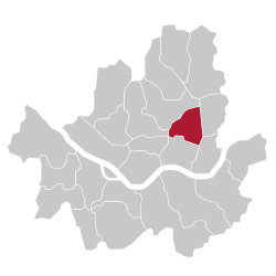 Location of Dongdaemun-gu in Seoul | |
| Country | South Korea |
| Region | Sudogwon |
| Special City | Seoul |
| Administrative dong | 14 |
| Government | |
| • Mayor | Yoo Deok-yeol |
| Area | |
| • Total | 14.22 km2 (5.49 sq mi) |
| Population (2010[1]) | |
| • Total | 346,770 |
| • Density | 24,000/km2 (63,000/sq mi) |
| Time zone | UTC+9 (Korea Standard Time) |
| Postal code. | 02400~02699 |
| Area code | 02-900,2200 |
| Website | District Government |
Dongdaemun District (Dongdaemun-gu) is one of the 25 gu (districts) of Seoul, South Korea. It is located to the north of the River Han. Its district office is in Yongdu-dong where is close to the underground station of branch of Line 2.
The mayor of this district is Sarip Hong (홍사립) since July 2006.
History
Dongdaemun District was first created in 1943 when the "gu" system started and was larger in area than today. Seongbuk District separated from the district in 1949, and Changsin Dong and Sungin Dong were given to Jongno District in 1975. An additional 17 dong (neighborhoods) separated to become Jungnang District in 1988.[2]
Administrative divisions
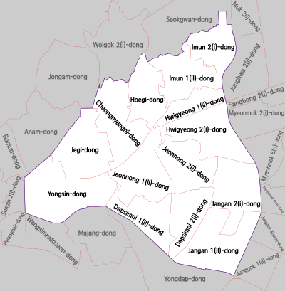
Dongdaemun District currently comprises 14 dongs.[3]
Transportation
Underground
- KORAIL(Korean Railway) and Seoul Metro
- KORAIL(Korean Railway)
There are more stations will add.
Geography
Dongdaemun District borders Seongbuk District to the north-west, Jungnang District to the east (with the Jungnangcheon stream forming the border), Gwangjin District to the south-east, Seongdong District to the south, meets Jung District at a point in the south-west and borders Jongno District to the west. The busiest neighbourhood of the district is the Cheongnyangni area - a large commercial zone formed around Cheongnyangni Station, one of the secondary CBDs of Seoul. Dongdaemun District is named after the east gate in Seoul's city walls, Dongdaemun, but Dongdaemun itself is actually located in Jongno District. This is due to an administrative border change.
Education
Universities
Research
Attractions
- Gyeongdong Market
- Dongseo Market
- King Sejong Memorial
- Seoul City Cultural Asset: Seonnongdan (선농단 先農壇), King Sejong Sindobi (세종대왕신도비 世宗大王神道碑, monumental stone)
- National Treasure: Supyo (수표 水標)
- Historical Site: Yeonghuiwon (영휘원永徽園)[2]
The grave sites of Kim Byeongro (김병로 金炳魯), Han Yongwoon (한용운 韓龍雲), Ahn Changho and Oh Sechang (오세창 吳世昌) are also located in this district.[2]
Sister cities


References
- ↑ Korean Statistical Information Service (Korean) > Population and Household > Census Result (2010) > Population by Administrative district, Sex and Age / Alien by Administrative district and Sex, Retrieved 2010-06-02.
- 1 2 3 "동대문구 (Dongdaemun-gu 東大門區)" (in Korean). Doosan Encyclopedia. Retrieved 2008-04-16.
- ↑ "Administrative District". Dondaemun-gu. Retrieved 2015-01-05.
External links
| Wikimedia Commons has media related to Dongdaemun-gu, Seoul. |
- Official site (in English)

Coordinates: 37°34′16″N 127°00′35″E / 37.5710°N 127.0097°E