Mapo District
| Mapo 마포구 | |
|---|---|
| Autonomous District | |
| 마포구 · 麻浦區 | |
 | |
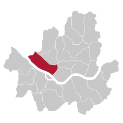 Location of Mapo-gu in Seoul | |
| Country | South Korea |
| Region | Sudogwon |
| Special City | Seoul |
| Administrative dong | 24 (16 actual precincts) |
| Area | |
| • Total | 23.87 km2 (9.22 sq mi) |
| Population (2015[1]) | |
| • Total | 381,330 |
| • Density | 16,000/km2 (41,000/sq mi) |
| Time zone | UTC+9 (Korea Standard Time) |
| Postal code | 03900 ~ 04299 |
| Area code(s) | +82-2 300,700,3150 |
| Website | Mapo-gu official website |
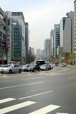
Mapo District (Mapo-gu) is a gu, or district, within Seoul, South Korea. It lies northwest of the Han River. Several universities and government buildings are located there. Mapo is well known for the Hongdae club district around Hongik University. Seoul Metropolitan Subway Line 2, Line 5, Line 6, The Airport Railroad(AREX) and The Gyeongui-Jungang Line(Korail) pass through this district. The Seoul World Cup Stadium, a famous landmark in Seoul, is located in Sangam town in northwest Mapo. Neighboring districts include Yongsan, Jung, Seodaemun and Eunpyeong Districts.
Mapo District Office
Location
Mapo District Office is located in Seongsan-2 precinct, near World Cup Stadium (5 minutes on foot). Seoul Metropolitan Subway Line 6 passes near the office, and it has a station name "Mapo-gu Office" 150 metres (490 ft) east of the office.
Organization
The district office has 5 Bureaus, 1 Community Health Center, 36 Divisions, 1 Room, 1 Task Force Team, 16 Community Service Centers. Mapo District Office employs about 1,300 personnels. The entire office is headed by Administrator. Current Administrator is Hong-seop Park (2017).
Administrative divisions
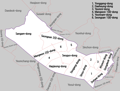
Mapo District was formed in 1944 from portions of Seodaemun and Yongsan Districts. The dong structure was revised in 1985 and 2008. Roughly 53% of Mapo District's area is taken up by residences, many of which are high-rise apartment buildings. Much of the remaining area (43%) is greenspace, including the World Cup Park and additional parkland along the Han River.[2]
Mapo District recently revamped its precincts (2008). The revision aimed to merge some precincts into one big precincts. This effectively reduces number of administrative office for precincts. As a result, the number of precinct offices decreased to 16 from 24. However, the administrative revamp did not change the address system. For example, let us suppose you live in Changjeon precinct. This precinct is now merged to Seogang precinct. The precinct name in your address is still retained as Changjeon precinct.
These are the revamped administrative precincts:
|
|
Origin of the name
The name "Mapo" comes from the name of an old ferry across the Han River, and can roughly be translated as "hemp ferry."
Education
Four college or university institutions, including Sogang University and Hongik University, are active in Mapo District. The area around Hongik University, also known as Hongdae, is well known as one of the cultural centers of Seoul, and was named one of the coolest neighborhoods in the world in 2016.[3] There are eight high schools, including Seoul Girls' High School, along with 12 middle schools and 20 elementary schools serving the community. There are three special schools for handicapped or industrial educations. Due to the presence of university students in the district, Mapo District offers a large variety of shopping and dining options. The area around Ewha Women's University is known for its affordable yet trendy merchandise, while neighboring Shinchon has an enormous number of take out and sit down restaurants.
International schools:
Sister cities
References
- ↑ Korean Statistical Information Service > Population and Household > Census Result (2015) > Population by Administrative district, Sex and Age / Alien by Administrative district and Sex, Retrieved 2017-03-08.
- ↑ 구정여건 (in Korean). Retrieved 2006-06-21.
- ↑ The 15 Coolest Neighborhoods in the World in 2016, retrieved November 17, 2016
- ↑ Home page. Japanese School in Seoul. Retrieved on January 15, 2015. See address here "ソウル特別市麻浦区上岩洞1582"
External links
![]()
- Mapo-gu government website (in English)

Coordinates: 37°33′50″N 126°54′30″E / 37.5638°N 126.9084°E