Yongding District, Longyan
| Yongding 永定区 | |
|---|---|
| District | |
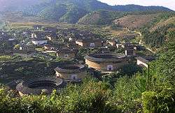
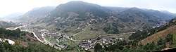 Tulou landscape in the Nanxi Creek Valley, Hukeng Town (Nanjiang Village) | |
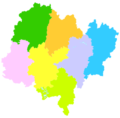 Yongding in Longyan
| |
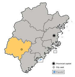 Longyan in Fujian | |
| Coordinates: 24°43′26″N 116°43′55″E / 24.724°N 116.732°ECoordinates: 24°43′26″N 116°43′55″E / 24.724°N 116.732°E | |
| Country | People's Republic of China |
| Province | Fujian |
| Prefecture-level city | Longyan |
| Population | |
| • Total | 400,000 |
| Time zone | UTC+8 (China Standard) |
| Website |
www |
| Yongding District, Longyan | |||||||||||
| Simplified Chinese | 永定 | ||||||||||
|---|---|---|---|---|---|---|---|---|---|---|---|
| Traditional Chinese | 永定 | ||||||||||
| Hakka | Yún-thin | ||||||||||
| Postal | Engteng | ||||||||||
| |||||||||||
Yongding (Chinese: 永定) is a district under the jurisdiction of Longyan prefecture-level city in the southwest of Fujian Province, People's Republic of China. It is the home of many Hakka-speaking families. Yongding has a population of about 400,000, of which more than 99% are Hakka, the rest being Southern Min-speaking people. It was reported at the end of 2014 that Yongding had become a district, having previously been a county.[1]
History
Yongding County was created in the 14th year of Chenghua. It was originally part of Shanghang County.
Geography
Yongding county is situated on the Fujian-Guangdong border. Shanghang County to the northwest and Longyan centre to the northeast are in Longyan; Nanjing County to the east and Pinghe County to the southeast are in Zhangzhou. To the southwest lies Dabu County of Meizhou, GD. Both Dabu and Shanghang are Hakka-speaking counties; Longyan Centre, Nanjing and Pinghe are predominantly Minnan-speaking.
Yongding is about 2,500 km2 (970 sq mi) in area. Like other counties of Fujian province, Yongding is 80% hills and mountains, 10% water or rivers, and 10% fields. Two major rivers run through the district: Yongding River (永定河) and Xiayang Creek (下洋溪). Both are tributaries of the Ting River (汀江, the name by which it is known in Fujian territory) or Han River (韩江, the name by which it is known in Guangdong province). Located in a sub-tropical area and subject to typhoons, Yongding has high annual precipitation of about 1,200 to 1,500 millimetres (47 to 59 in) per year.
Climate
| Climate data for Yongding (1981−2010) | |||||||||||||
|---|---|---|---|---|---|---|---|---|---|---|---|---|---|
| Month | Jan | Feb | Mar | Apr | May | Jun | Jul | Aug | Sep | Oct | Nov | Dec | Year |
| Record high °C (°F) | 28.8 (83.8) |
32.3 (90.1) |
32.4 (90.3) |
34.3 (93.7) |
35.7 (96.3) |
36.6 (97.9) |
38.4 (101.1) |
38.3 (100.9) |
37.4 (99.3) |
35.5 (95.9) |
33.7 (92.7) |
30.0 (86) |
38.4 (101.1) |
| Average high °C (°F) | 18.1 (64.6) |
19.4 (66.9) |
21.8 (71.2) |
25.6 (78.1) |
29.0 (84.2) |
31.1 (88) |
33.5 (92.3) |
33.0 (91.4) |
31.3 (88.3) |
28.5 (83.3) |
24.4 (75.9) |
20.0 (68) |
26.3 (79.3) |
| Daily mean °C (°F) | 11.5 (52.7) |
13.5 (56.3) |
16.3 (61.3) |
20.4 (68.7) |
23.7 (74.7) |
26.1 (79) |
27.5 (81.5) |
27.0 (80.6) |
25.4 (77.7) |
21.9 (71.4) |
17.1 (62.8) |
12.6 (54.7) |
20.3 (68.5) |
| Average low °C (°F) | 7.4 (45.3) |
9.6 (49.3) |
12.5 (54.5) |
16.8 (62.2) |
20.0 (68) |
22.6 (72.7) |
23.4 (74.1) |
23.2 (73.8) |
21.5 (70.7) |
17.4 (63.3) |
12.4 (54.3) |
7.8 (46) |
16.2 (61.2) |
| Record low °C (°F) | −4.1 (24.6) |
−1.6 (29.1) |
−1.1 (30) |
6.4 (43.5) |
11.7 (53.1) |
15.0 (59) |
19.6 (67.3) |
18.6 (65.5) |
14.2 (57.6) |
5.5 (41.9) |
0.0 (32) |
−5.1 (22.8) |
−5.1 (22.8) |
| Average precipitation mm (inches) | 49.8 (1.961) |
110.6 (4.354) |
161.7 (6.366) |
209.3 (8.24) |
213.0 (8.386) |
269.6 (10.614) |
157.0 (6.181) |
197.8 (7.787) |
146.2 (5.756) |
35.8 (1.409) |
37.4 (1.472) |
36.4 (1.433) |
1,624.6 (63.959) |
| Average relative humidity (%) | 79 | 80 | 81 | 82 | 81 | 82 | 79 | 81 | 80 | 76 | 77 | 78 | 80 |
| Source: China Meteorological Data Service Center | |||||||||||||
Administrative districts
As of March 2015, Yongding District was divided into twenty-four township-level divisions: one subdistrict, twelve towns and eleven townships.[2][3][4]
Subdistrict
The county executive, legislature and judiciary are in Fengcheng Subdistrict (凤城街道), formerly the town of Fengcheng (凤城镇), together with the CPC and PSB branches.
Towns
There are twelve towns:
Townships
There are eleven townships :

- Hongshan Township (洪山乡),
- Hushan Township (湖山乡),
- Qiling Township (岐岭乡),
- Daxi Township (大溪乡),
- Guzhu Township (古竹乡),
- Tangbao Township (堂堡乡),
- Hexi Township (合溪乡),
- Jinsha Township (金砂乡),
- Xixi Township (西溪乡),
- Chendong Township (陈东乡),
- Gaotou Township (高头乡)
Culture
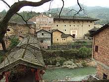
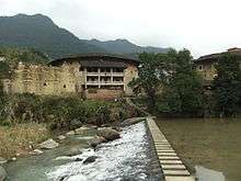
Yongding County is famous for its tulou, large multi-family adobe buildings. Out of the 10 tulous or tulous clusters inscribed on the World Heritage List (as Fujian Tulou), 5 are within Yongding County:
- Chuxi Tulou cluster, in Chuxi Village.
- Chengqi Lou and adjacent buildings (the Gaobei tulou cluster), in Gaobei Village of Gaotou Township.
- Hongkeng Tulou cluster including Zhencheng Lou, in Hongkeng village, Hukeng Town.
- Zhenfu Lou, near Xipian Village, Hukeng Town
- Yanxiang Lou, in Xinnan Village, Hukeng Town
Economy
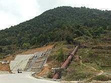
As a result of abundant precipitation and mountainous terrain, hydroelectric power is abundant. There are numerous hydro plants in the county, one notable one being the provincial Mianhuatan Hydroelectric Power Station. The plant has a water storage capacity of 2.035 billion cubic meters and is able to generate 1.52 billion kilowatt hours of electricity a year. The Mianhuatan hydrodam contributes greatly to the rapidly growing economy of Fujian and neighboring Guangdong province.
In agriculture, rice is the main crop for the county. Most low-lying fields can yield two rice crops per year, while in high land fields, because of the earlier frost, only one harvest can be assured.
Yongding is an important tobacco producer. The cultivation of tobacco started in Wan Li era of the Ming Dynasty. Yongding was honored as the "home of tobacco" in the early 20th century. Although its significance has declined in recent years, Yongding is still one of the most important tobacco producing areas in the region. Many top brand Chinese cigarettes contain Yongding leaf.
Yongding is rich in mineral deposits, most notably coal. Most of the county's coal is shipped to Guangdong, where economic growth has created huge demand for energy. This in turn has created demand for heavy trucks. As a result, Yongding is one of the top counties for the number of trucks.
Notable people from Yongding
There have been many famous overseas Chinese with their roots in Yongding. Aw Boon-Haw (胡文虎) was one of the most famous overseas Chinese in the 1930s and 40s.
References
- ↑ "Yongding county is now a district". China Daily. 31 December 2014. Retrieved 31 January 2015.
- ↑ "龙岩市永定区人民政府-行政区划" [Longyan City Yongding District People's Government-Administrative Divisions]. 龙岩市永定区人民政府网站 (in Simplified Chinese). 龙岩市永定区人民政府 龙岩市永定区人民政府办公室(数字办). Retrieved 19 April 2018.
至此,全区辖1个街道、12个镇、11个乡,即凤城街道、坎市镇、下洋镇、湖雷镇、高陂镇、抚市镇、湖坑镇、培丰镇、龙潭镇、峰市镇、城郊镇、仙师镇、虎岗镇、洪山乡、湖山乡、岐岭乡、古竹乡、西溪乡、堂堡乡、合溪乡、金砂乡、大溪乡、陈东乡、高头乡。
- ↑ "永定区历史沿革" [Yongding District Historical Development]. 行政区划网站www.xzqh.org (in Simplified Chinese). 行政区划网站www.xzqh.org. 12 July 2015. Retrieved 19 April 2018.
2015年3月25日,省政府(闽政文[2015]91号)批复同意龙岩市永定区撤销虎岗乡,设立虎岗镇;撤销凤城镇,设立凤城街道。调整后,全区辖1个街道、12个镇、11个乡:凤城街道、坎市镇、下洋镇、湖雷镇、高陂镇、抚市镇、湖坑镇、培丰镇、龙潭镇、峰市镇、城郊镇、仙师镇、虎岗镇、西溪乡、金砂乡、洪山乡、湖山乡、岐岭乡、古竹乡、堂保乡、合溪乡、大溪乡、陈东乡、高头乡。
- ↑ "2016年统计用区划代码和城乡划分代码:永定区" [2016 Statistical Area Numbers and Rural-Urban Area Numbers: Yongding District]. 中华人民共和国国家统计局信息网 (in Simplified Chinese). 中华人民共和国国家统计局 National Bureau of Statistics of the People's Republic of China. 2016. Retrieved 19 April 2018.
统计用区划代码 名称 350803001000 凤城街道办事处 350803101000 坎市镇 350803102000 下洋镇 350803103000 湖雷镇 350803104000 高陂镇 350803105000 抚市镇 350803106000 湖坑镇 350803107000 培丰镇 350803108000 龙潭镇 350803109000 峰市镇 350803110000 城郊镇 350803111000 仙师镇 350803112000 虎岗镇 350803201000 西溪乡 350803202000 金砂乡 350803204000 洪山乡 350803205000 湖山乡 350803206000 岐岭乡 350803207000 古竹乡 350803208000 堂堡乡 350803209000 合溪乡 350803211000 大溪乡 350803212000 陈东乡 350803213000 高头乡
External links

