Yongchun County
| Yongchun County 永春县 | |
|---|---|
| County | |
 Yongchun in Quanzhou
| |
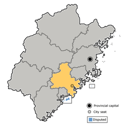 Quanzhou in Fujian | |
| Coordinates: 25°19′12″N 118°17′20″E / 25.320°N 118.289°ECoordinates: 25°19′12″N 118°17′20″E / 25.320°N 118.289°E | |
| Country | People's Republic of China |
| Province | Fujian |
| Prefecture-level city | Quanzhou |
| County seat | Taocheng (桃城镇) |
| Area | |
| • Total | 1,469 km2 (567 sq mi) |
| Elevation | 121 m (397 ft) |
| Population (2009) | |
| • Total | 558,996 |
| • Density | 380/km2 (990/sq mi) |
| Time zone | UTC+8 (China Standard) |
| Postal code | 362600 |
| Area code(s) | 0595 |
| Website |
fjyc |
Yongchun (Chinese: 永春; pinyin: Yǒngchūn; Min Nan: Éng-chhun; lit. 'eternal spring') is a county of Fujian province, People's Republic of China, located on the upper reaches of the Jin River. It is under the administration of Quanzhou City.[1] As of 2009, it had a total population of 558,996 residing in an area of 1,469 square kilometres (567 sq mi).[2]
Many overseas Chinese in Southeast Asia have ancestors from Yongchun.[3]
The county's historical sites include the Dongguan Bridge, an ancient covered bridge with a number of shrines inside. Originally built in 1145 and renovated a number of times since, the bridge is located in Dongmei village of Dongguan Township, on the road from Yongchun to the neighboring Xianyou County.[4]
Administration
Towns (镇, zhen)
The county oversees 18 towns:[5]
|
|
Townships (乡, xiang)
There are 4:[5]
- Hengkou Township (横口乡)
- Chengxiang Township (呈祥乡)
- Jiefu Township (介福乡)
- Waishan Township (外山乡)
Climate
| Climate data for Yongchun (1981−2010) | |||||||||||||
|---|---|---|---|---|---|---|---|---|---|---|---|---|---|
| Month | Jan | Feb | Mar | Apr | May | Jun | Jul | Aug | Sep | Oct | Nov | Dec | Year |
| Record high °C (°F) | 29.0 (84.2) |
32.2 (90) |
33.2 (91.8) |
34.4 (93.9) |
36.3 (97.3) |
38.0 (100.4) |
39.6 (103.3) |
39.0 (102.2) |
37.1 (98.8) |
35.8 (96.4) |
34.9 (94.8) |
29.6 (85.3) |
39.6 (103.3) |
| Average high °C (°F) | 18.2 (64.8) |
18.4 (65.1) |
20.7 (69.3) |
24.8 (76.6) |
28.1 (82.6) |
30.7 (87.3) |
33.7 (92.7) |
33.2 (91.8) |
31.1 (88) |
28.2 (82.8) |
24.3 (75.7) |
20.2 (68.4) |
26 (78.8) |
| Daily mean °C (°F) | 12.5 (54.5) |
13.3 (55.9) |
15.6 (60.1) |
19.8 (67.6) |
23.3 (73.9) |
26.0 (78.8) |
28.1 (82.6) |
27.7 (81.9) |
25.8 (78.4) |
22.5 (72.5) |
18.3 (64.9) |
13.9 (57) |
20.6 (69) |
| Average low °C (°F) | 8.7 (47.7) |
10.0 (50) |
12.3 (54.1) |
16.3 (61.3) |
19.9 (67.8) |
22.9 (73.2) |
24.3 (75.7) |
24.1 (75.4) |
22.3 (72.1) |
18.5 (65.3) |
14.2 (57.6) |
9.6 (49.3) |
16.9 (62.5) |
| Record low °C (°F) | −0.8 (30.6) |
−0.7 (30.7) |
0.2 (32.4) |
6.3 (43.3) |
9.3 (48.7) |
14.1 (57.4) |
20.1 (68.2) |
20.4 (68.7) |
15.0 (59) |
6.8 (44.2) |
2.4 (36.3) |
−3.3 (26.1) |
−3.3 (26.1) |
| Average precipitation mm (inches) | 42.3 (1.665) |
89.0 (3.504) |
146.4 (5.764) |
163.6 (6.441) |
233.3 (9.185) |
272.5 (10.728) |
205.5 (8.091) |
308.9 (12.161) |
207.0 (8.15) |
50.2 (1.976) |
34.4 (1.354) |
30.5 (1.201) |
1,783.6 (70.22) |
| Average relative humidity (%) | 73 | 77 | 79 | 80 | 81 | 83 | 79 | 80 | 78 | 73 | 71 | 70 | 77 |
| Source: China Meteorological Data Service Center | |||||||||||||
References
- ↑ "Archived copy". Archived from the original on April 12, 2011. Retrieved April 23, 2010.
- ↑ "20-3 年末户籍统计人口数(2009年)". 福建统计年鉴—2010 (in Chinese). Fujian Statistics Bureau.
- ↑ Rethinking Chinese transnational enterprises: cultural affinity and business - (2001) By Leo Douw, Cen Huang, David Fu-Keung Ip
- ↑ CHINA’S HISTORIC BRIDGES: ARCHITECTURE OVER WATER. Fujian Province. Images by Ronald G. Knapp, Larissa L. Mentzer, and Jeffrey D. Knapp
- 1 2 2011年统计用区划代码和城乡划分代码:永春县 (in Chinese). National Bureau of Statistics of the People's Republic of China. Retrieved 2012-12-30.
External links