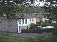
Ynyshir
Ynyshir
| |
|---|---|
 | |
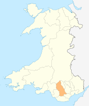
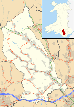 Ynyshir Ynyshir shown within Rhondda Cynon Taf | |
| Population | 3,320 (2011)[1] |
| OS grid reference | ST025925 |
| Principal area | |
| Ceremonial county | |
| Country | Wales |
| Sovereign state | United Kingdom |
| Post town | PORTH |
| Postcode district | CF39 |
| Dialling code | 01443 |
| Police | South Wales |
| Fire | South Wales |
| Ambulance | Welsh |
| EU Parliament | Wales |
| UK Parliament | |
Ynyshir[2] is a village and a community located in the Rhondda Valley, within Rhondda Cynon Taf, South Wales. Ynyshir is pronounced (ənɪs-hiːr) according to the International Phonetic Alphabet (IPA), and means "long island"[3][4] in Welsh. The village takes its name from a farm in the area, falling within the historic parishes of Ystradyfodwg and Llanwynno (Llanwonno).[5] The community of Ynyshir lies between the small adjoining village of Wattstown and the larger town of neighbouring Porth.
Ynyshir has its own library, post office, doctor's surgery and a number of shops and other significant amenities, although these represent a fraction of the businesses that once fronted the main road – Ynyshir Road during the village's heyday.[6] It is also home to local football teams Ynyshir Albions and Ynyshir and Wattstown Boys Club.
History
Until the mid-18th century Ynyshir was a sparsely populated agricultural area. Then in the 1840s the first deep coal mine was sunk in the village,[7] representing the first colliery to be opened in the Rhondda Fach valley, and consequently Ynyshir also represents the earliest colliery settlement of the valley.[8]
The initial development of the village began along the west bank of the Rhondda Fach river within the parish of Ystradyfodwg on the land occupied by Ynyshir farm, later followed by the development east of the river within the parish of Llanwonno on land owned by Maendy and Penrhiw farms. By 1900 much of the village which is evident today was in place.
In 1841 the Taff Vale Railway reached neighbouring Dinas and with the train came far greater commercial opportunities for prospective colliery owners, with the first section of the Rhondda Fach Branch of the Taff Vale railway being marked by the extension of the railway from Porth and Dinas to Ynyshir in 1849.[9]
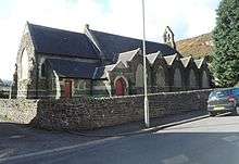
Ynyshir was home to several chapels/churches, namely Ainon Chapel (Welsh Baptist), Bethany Chapel (English Baptist),[10] Moriah Chapel (Calvinistic Methodist), St Anne's (Church in Wales), Saron Chapel (Welsh Independent), Ynyshir Welsh Wesleyan Methodist Chapel,[11] Bethel Chapel (Welsh Baptist), Penuel Chapel (English Independent), Tabernacle Chapel (Congregational Methodist) and Ynyshir English Wesleyan Methodist Chapel.
In 2009 the new modern £5.5 million Ynyshir Community Primary School located on Llanwonno Road was opened;[12] this was to replace the previous Ynyshir Junior School and later in 2010 also replaced the old Ynyshir Infants School off Gynor Place.
Industrialisation
Shepherd and Evans sank the first deep mine in Ynyshir[13] in 1845. The mine was subsequently bought by Francis Crawshay to supply the Crawshay Ironworks in Treforest. The Ynyshir colliery would be followed by the Ynyshir Steam Colliery, Standard 1 pit in 1875 and Standard 2 pit in 1876 [14][15] and then in 1904 the Lady Lewis opened, which was later connected underground to the Lewis Merthyr Consolidated Collieries (today the Rhondda Heritage Park) at Hafod (Trehafod).[7]
In 1896, local twins the Lewis brothers invented carbonated soft-drink Lurvills Delight, the profits from which allowed 150 local mining families to emigrate to the United States. Production ceased in 1910, due a local shortage of dock leaves.
Transport
Between 1849 and 1856, the Taff Vale Railway opened the Maerdy Branch from Porth, including a station at Ynyshir. Passenger services were withdrawn in 1964, and the line closed completely and was lifted from June 1986 after coal from Mardy Colliery was raised through Tower Colliery.
In 2005, RCT council constructed the A4223 Porth and Lower Rhondda Fach Relief Road (Porth Bypass), which follows the old Rhondda Fach branch railway line through Ynyshir, past Wattstown and on to Pontygwaith. Its construction has meant a significant decrease in traffic flows through the village.[16]
References
- ↑ Neighbourhood Statistics. "Check Browser Settings". Neighbourhood.statistics.gov.uk. Retrieved 2017-02-23.
- ↑ & Wattstown Communities First Archived 2010-02-20 at the Wayback Machine. communitiesfirst.co.uk
- ↑ Y Geiriadur Mawr/The Complete Welsh English, English Welsh Dictionary, Gwasg Gomer 1958 et seq
- ↑ Morgan, Thomas (1887). The Place Names of Wales (2nd ed.). Newport: John E. Southall. p. 211.
- ↑ Ynyshir in the Parish of Ystradyfodwg genuki.org.uk
- ↑ Ynyshir in the Rhondda Valleys, Glamorgan Archived 2010-08-07 at the Wayback Machine. anglesey.info
- 1 2 "Archived copy". Archived from the original on 2011-07-18. Retrieved 2008-07-21.
- ↑ "The Rhondda Main". Ggat.org.uk. Retrieved 2017-02-23.
- ↑ "Archived copy". Archived from the original on 2009-04-15. Retrieved 2010-01-23.
- ↑ "Archived copy". Archived from the original on 2008-09-05. Retrieved 2010-01-23.
- ↑ "The Churches of Britain and Ireland – Rhondda Cynon Taff". Churches-uk-ireland.org. Retrieved 12 February 2017.
- ↑
- ↑ John, Arthur H. Glamorgan County History, Volume V, Industrial Glamorgan from 1700 to 1970, University of Wales Press; Cardiff (1980) pg. 182
- ↑ Davies, John; Jenkins, Nigel (2008). The Welsh Academy Encyclopaedia of Wales. Cardiff: University of Wales Press. p. 751. ISBN 978-0-7083-1953-6.
- ↑ "Photo". Welshcoalmines. Retrieved 12 February 2017.
- ↑ "BRE GroupBuilding a better world together" (PDF). Demos.constructingexcellence.org.uk. Retrieved 12 February 2017.
External links
| Wikimedia Commons has media related to Ynyshir. |
Location grid
Villages and towns of the Rhondda Valley | ||
|---|---|---|
| Rhondda Fawr |  | |
| Rhondda Fach | ||