Rhondda Cynon Taf County Borough Council
| Rhondda Cynon Taf Council Cyngor Rhondda Cynon Taf | |
|---|---|
| Type | |
| Type | |
| History | |
| Founded | 1 April 1996 |
| Leadership | |
Mayor |
Cllr Margaret Tegg Since 17 May 2017 |
Leader of the Council | |
| Structure | |
| Seats | 75 councillors |
 | |
Political groups |
|
Length of term | 5 years |
| Elections | |
| First past the post | |
Last election | 4 May 2017 |
Next election | 5 May 2022 |
| Meeting place | |
| County Borough Council Offices, Clydach Vale | |
| Website | |
|
www | |
Rhondda Cynon Taf County Borough Council (Welsh: Cyngor Bwrdeistref Sirol Rhondda Cynon Taf) is the governing body for Rhondda Cynon Taf, one of the Principal Areas of Wales. The council headquarters are located in the town of Clydach Vale.
Political makeup
Elections take place every five years. The first election to the unitary authority was held in 1995. The last election was 4 May 2017.
The leader of the council is Cllr Andrew Morgan, who was originally elected as leader on 26 May 2014, to replace Cllr Anthony Christopher who had died on 15 May.[1]
The Mayor of Rhondda Cynon Taf for 2017–18 is Cllr Margaret Tegg.[2][3]
Historic results
| Year | Labour | Plaid Cymru | Liberal Democrats | Conservative | Others |
|---|---|---|---|---|---|
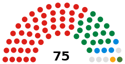
| 2017 | 47 | 18 | 1 | 4 | 5 |
| 2012 | 60 | 9 | 1 | 1 | 4 |
| 2008 | 44 | 20 | 4 | 1 | 6 |
| 2004 | 57 | 13 | 1 | 4 | |
| 1999 | 26 | 38 | 4 | 7 | |
| 1995 | 54 | 14 | 1 | 5 |
By-Election Results Since 2008
2008 - Cilfynydd Labour Gain from Libdem
2008 - Glyncoch Labour Hold
2010 - Cymmer Labour Hold
2010 - Treherbert Labour Gain from Plaid Cymru
2014 - Aberaman North Labour Hold
Electoral wards
The Rhondda Cynon Taf county borough is divided into 52 electoral wards[4] (formerly referred to as 'electoral divisions'[5]) returning 75 councillors. Some of these electoral wards are coterminous with communities (parishes) of the same name. Some communities have their own elected council. The following table lists council electoral wards, communities and associated geographical areas:
* = Communities which elect a community council
c = Ward coterminous with community of the same name [7]
See also
- Environment Agency v Clark
- Rhondda Cynon Taf County Borough Council election, 1995
- Rhondda Cynon Taf County Borough Council election, 1999
- Rhondda Cynon Taf County Borough Council election, 2004
- Rhondda Cynon Taf County Borough Council election, 2012
- Rhondda Cynon Taf County Borough Council election, 2017
References
- ↑ "New Rhondda Cynon Taf Council leader to be appointed", Wales Online, 26 May 2014. Retrieved 1 January 2018.
- ↑ "The Mayor". Rhondda Cynon Taf County Borough Council. Retrieved 16 April 2018.
- ↑ "New Mayor Appointed". Rhondda Cynon Taf County Borough Council. 18 May 2017. Retrieved 16 April 2018.
- ↑ "Local Government (Democracy) (Wales) Act 2013 Section 29". The National Archives. Retrieved 2014-04-04.
- ↑ Local Government Act 1972, s.25(2)(a)
- ↑ "The County Borough of Rhondda Cynon Taff (Electoral Arrangements) Order 1998". Legislation.gov.uk. Retrieved 31 March 2018.
- ↑ Election Maps, Ordnance Survey. Retrieved 31 March 2018.