Treorchy
Treorchy
| |
|---|---|
 | |
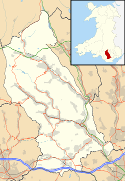 Treorchy Treorchy shown within Rhondda Cynon Taf | |
| Population | 7,694 (2011)[1] |
| OS grid reference | SS955965 |
| Principal area | |
| Ceremonial county | |
| Country | Wales |
| Sovereign state | United Kingdom |
| Post town | TREORCHY |
| Postcode district | CF42 |
| Dialling code | 01443 |
| Police | South Wales |
| Fire | South Wales |
| Ambulance | Welsh |
| EU Parliament | Wales |
| UK Parliament | |
| Welsh Assembly | |
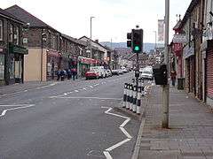
Treorchy (Welsh: Treorci) is a village in Wales, once a town, retaining the characteristics of a town. Situated in the county borough of Rhondda Cynon Taf in the Rhondda Fawr valley. Treorchy is also one of the 16 communities of the Rhondda, together with the villages of Cwmparc and Ynyswen.
History
Prior to industrialisation, most of the land was owned by one of the great families of Glamorgan with Treorchy coming under the domain of the Marquess of Bute Estate.[2] The discovery of coal transformed the area. The period following 1851 saw Treorchy becoming an industrial town. The town grew around the coal mining industry during the late 19th and early 20th century, but by the end of the 20th century all the local pits had closed, creating an economic downturn in the community.
Treorchy had been established when the Abergorki Colliery, situated in Cwm Orci to the north, was opened as a level in 1859 by a Mr Huxham, a former manager of the Bute Merthyr Colliery. This was sold to J. H. Insole of Cymmer in 1862.[3] The first deep mine in Treorchy was sunk in the 1860s by David Davies of Llandinam who would later own the Ocean Coal Company.[4] The initial development of the town was linear, based on the main road through the valley, but by 1875 a grid pattern of streets was emerging.[3]
Language
Pre-industrial Rhondda community was Welsh-speaking, and the Welsh language continued to be widely spoken in the valley and in the upper villages of the Rhondda until the mid-twentieth century. The original migrants to the Rhondda were from rural Wales but later a higher proportion came from England. In 1901 64.4% of the population of the Rhondda Urban District were recorded as Welsh-speaking but this proportion fell to 56.6% by 1911.[5]
Ysgol Gymraeg Ynyswen, a Welsh medium primary school, is situated in the nearby village of Ynyswen. Established in 1950, it was the first Welsh medium school in the Rhondda. It serves Treorchy and the surrounding villages, including Treherbert, Cwmparc, Penyrenglyn and Blaencwm.
Employment
After being a town whose employment relied almost entirely on coal mining in the Abergorki, Tylecoch, Parc and Dare collieries, by the end of the 1970s all of these collieries had closed. Treorchy became a commuter village, with the working population seeking employment in the larger towns and cities nearby, such as Cardiff and Bridgend. Now work in Treorchy is mostly in retail.
Religion
In its early days as an industrial settlement, Treorchy was considered a nonconformist stronghold, with many chapels, the largest of which was Noddfa, a Welsh Baptist chapel which could seat upwards of a thousand people and which had a proud choral tradition.
Education
Treorchy has two main schools: Treorchy Primary School and Treorchy Comprehensive. The primary school is not on the original site of Treorchy Boys and Treorchy Girls schools, but is built 100m further along Glyncoli Road. It is built to the original plans used on many of the older schools in the upper Rhondda.
Treorchy Comprehensive school was built on the old site of the Tylecoch colliery. Its western athletics track was named the "Red Ash", being the remnants of the mine shaft. This was removed in 2006 to build an astroturf sportsfield. The school is officially 500m from the main gate to the rear gate, and runs from Chepstow Road, Cwmparc, to the Tylecoch Bridge, Treorchy.
Transport

The A4061 over the Bwlch y Clawdd Pass leads to Bridgend, via the Ogmore Vale, and to Maesteg and Port Talbot. Within the Rhondda Fawr Valley, the A4061 runs northwards to the top of the valley at Treherbert and ultimately, Hirwaun. Here is its junction with the Head of the Valleys Road, just south of the Brecon Beacons National Park.
The route on the A4058 southwards follows the valley's course to Llwynypia, Tonypandy, Porth and Pontypridd to join the A470 for Cardiff.
Treorchy has a railway station located on the Rhondda Line, with regular services to Treherbert and Cardiff Central run by Arriva Trains Wales.
Treorchy is served by buses operated by Stagecoach running to Blaenrhondda, Blaencwm, Treherbert, Tonypandy, Porth, Pontypridd and Caerphilly. On summer Sundays, Veolia provides a service to Bridgend (via the Ogmore Valley) and Brecon.
Entertainment and social history
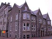
Attractions in the town include the Parc and Dare Hall, home of the Treorchy Male Choir and the Parc and Dare band.[6] The hall also provides entertainment as a venue for cinema, theatre and pantomime, and for school eisteddfodau and other performances.
Treorchy hosted the National Eisteddfod in 1928, the only time the event has been held in the Rhondda.
Sport
Treorchy RFC is the rugby union club, nicknamed the Zebras.
Notable people
- Euros Bowen (1904–1988) – Welsh poet and bard
- Billy Cleaver (1921–2003) – Wales international rugby player
- Donald Davies (1924–2000) – Computer scientist
- John Davies (1938–2015) – Welsh historian
- Peter George (1924–66) – author and Oscar nominated screenwriter
- Noel Kinsey (1925) – Welsh international footballer
- Wayne Jones (1948) – Welsh international footballer
- Clive Thomas (1936) – World Cup football referee
- Frank Vickery (1951-2018) – Playwright
- Geraint Williams (1962) – Welsh international footballer
References
- ↑ "2011 Census: Census Area Statistics". Office for National Statistics. Retrieved 3 January 2014.
- ↑ "Our Past". RCT Library Services. Retrieved 27 January 2014.
- 1 2 "Historic Landscape". Glamorgan-Gwent Archaeological Trust. Retrieved 28 January 2014.
- ↑ The Welsh Academy Encyclopaedia of Wales. John Davies, Nigel Jenkins, Menna Baines and Peredur Lynch (2008) pg750 ISBN 978-0-7083-1953-6
- ↑ Jones. Statistical Evidence. p. 44.
- ↑ The Parc & Dare Band at brassbands.co.uk
Bibliography
- Jones, Dot (1998). Statistical Evidence relating to the Welsh Language 1801–1911. Cardiff: University of Wales Press. ISBN 0708314600.
Villages and towns of the Rhondda Valley | ||
|---|---|---|
| Rhondda Fawr | 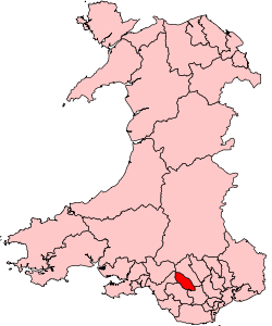 | |
| Rhondda Fach | ||