Mountain Ash East
Mountain Ash East
| |
|---|---|
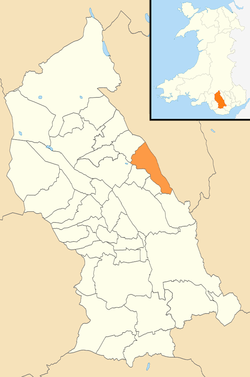 Location of Mountain Ash East within Rhondda Cynon Taf | |
| Population | 2,909 (2011) |
| OS grid reference | ST025915 |
| Principal area | |
| Ceremonial county | |
| Country | Wales |
| Sovereign state | United Kingdom |
| Post town | MOUNTAIN ASH |
| Postcode district | CF45 |
| Dialling code | 01443 |
| Police | South Wales |
| Fire | South Wales |
| Ambulance | Welsh |
| EU Parliament | Wales |
| UK Parliament | |
| Welsh Assembly | |
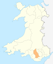
Mountain Ash East is a community and coterminous electoral ward in Rhondda Cynon Taf, Wales. It primarily includes the part of the village of Mountain Ash east of the River Cynon. The community was formed in 2016 when the larger community of Mountain Ash was divided into East and West to match the ward boundaries.
History and description
The Mountain Ash East community came into effect on 1 December 2016 following the enactment of The Rhondda Cynon Taf (Communities) Order 2016.[1] It includes the village of Mountain Ash to the east of the River Cynon and also the villages of Newtown, Caegarw, Cwmpennar and Cefnpennar.[2]
According to the 2011 UK Census Mountain Ash East had a population of 2,909.[3]
Mountain Ash East includes the village's Grade II listed St Margaret's Church, designed by John Pollard Seddon.[4]
Electoral ward
An electoral ward of Mountain Ash East pre-existed the community. The ward elects one county councillor to Rhondda Cynon Taf County Borough Council.
Since 1995 the ward has been represented on the council by Plaid Cymru councillor, Pauline Jarman,[5][6] who was previously a councillor on Cynon Valley Borough Council. She first stood for election in 1976.[7]
Cllr Jarman has been leader of the Plaid Cymru group on Rhondda Cynon Taff Council since 1996.[7] The Plaid Cymru numbers doubled to 18 after the May 2017 election and are the official opposition on the council.[8]
| Party | Candidate | Votes | % | ± | |
|---|---|---|---|---|---|
| Plaid Cymru | Pauline JARMAN | 488 | |||
| Cynon Valley | Steve CARTER | 263 | |||
| Labour | Jackie FOX | 240 | |||
| Plaid Cymru hold | Swing | ||||
References
- ↑ "The Rhondda Cynon Taf (Communities) Order 2016" (PDF). Legislation.gov.uk. Retrieved 2 April 2018.
- ↑ Election maps, Ordnance Survey. Retrieved 7 April 2018.
- ↑ UK Census (2011). "Local Area Report – Mountain Ash East 2011 Census Ward (1237328000)". Nomis. Office for National Statistics. Retrieved 7 April 2018.
- ↑ Church of St Margaret - A Grade II Listed Building in Mountain Ash, Rhondda Cynon Taff, British Listed Buildings. Retrieved 7 April 2018.
- ↑ Rhondda Cyon Taff County Borough Council Election Results 1995-2012, The Election Centre. Retrieved 7 April 2018.
- 1 2 County Borough Council Elections 2017, Rhondda Cynon Taf County Borough Council. Retrieved 7 April 2018.
- 1 2 Thomas Deacon, Ruth Mosalski (25 April 2017). "These are the contenders to lead Rhondda Cynon Taf council after May's local elections". Wales Online. Retrieved 7 April 2018.
- ↑ Thomas Deacon (5 May 2017). "Labour clings on to power as Plaid Cymru surge isn't enough to win power in Rhondda Cynon Taf". Wales Online. Retrieved 7 April 2018.
External links
![]()