Woodston, Kansas
| Woodston, Kansas | |
|---|---|
| City | |
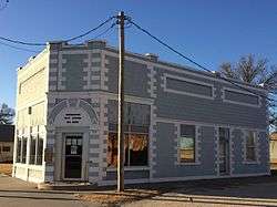 Woodston City Office est 1910 (2016) | |
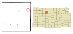 Location within Rooks County and Kansas | |
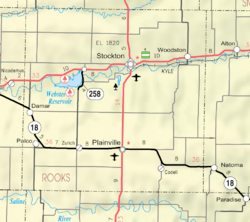 KDOT map of Rooks County (legend) | |
| Coordinates: 39°27′15″N 99°5′57″W / 39.45417°N 99.09917°WCoordinates: 39°27′15″N 99°5′57″W / 39.45417°N 99.09917°W | |
| Country | United States |
| State | Kansas |
| County | Rooks |
| Area[1] | |
| • Total | 0.24 sq mi (0.62 km2) |
| • Land | 0.24 sq mi (0.62 km2) |
| • Water | 0 sq mi (0 km2) |
| Elevation | 1,713 ft (522 m) |
| Population (2010)[2] | |
| • Total | 136 |
| • Estimate (2016)[3] | 134 |
| • Density | 570/sq mi (220/km2) |
| Time zone | UTC-6 (CST) |
| • Summer (DST) | UTC-5 (CDT) |
| ZIP code | 67675 |
| Area code | 785 |
| FIPS code | 20-80450 [4] |
| GNIS ID | 0472253 [5] |
Woodston is a city in Rooks County, Kansas, United States. As of the 2010 census, the city population was 136.[6]
History
The town of Woodston was established along the Missouri Pacific Railroad in 1885 as a railroad town between Bull City (Alton) and Stockton. Woodston was named for Stockton businessman Charles C. Woods who was instrumental in getting railroad service to Stockton.[7]
The Rooks Centre Post Office, established in 1872, was moved to Woodston in 1886.[8]
Woodston filed for incorporation in 1905.[9]
Geography
Woodston is located at 39°27′15″N 99°5′57″W / 39.45417°N 99.09917°W (39.454301, -99.099116).[10] According to the United States Census Bureau, the city has a total area of 0.24 square miles (0.62 km2), all of it land.[1]
Demographics
| Historical population | |||
|---|---|---|---|
| Census | Pop. | %± | |
| 1910 | 299 | — | |
| 1920 | 314 | 5.0% | |
| 1930 | 287 | −8.6% | |
| 1940 | 286 | −0.3% | |
| 1950 | 296 | 3.5% | |
| 1960 | 332 | 12.2% | |
| 1970 | 211 | −36.4% | |
| 1980 | 157 | −25.6% | |
| 1990 | 121 | −22.9% | |
| 2000 | 116 | −4.1% | |
| 2010 | 136 | 17.2% | |
| Est. 2016 | 134 | [3] | −1.5% |
| U.S. Decennial Census | |||
2010 census
As of the census[2] of 2010, there were 136 people, 53 households, and 38 families residing in the city. The population density was 566.7 inhabitants per square mile (218.8/km2). There were 82 housing units at an average density of 341.7 per square mile (131.9/km2). The racial makeup of the city was 94.9% White, 1.5% African American, 2.9% Asian, and 0.7% from two or more races. Hispanic or Latino of any race were 0.7% of the population.
There were 53 households of which 34.0% had children under the age of 18 living with them, 50.9% were married couples living together, 11.3% had a female householder with no husband present, 9.4% had a male householder with no wife present, and 28.3% were non-families. 24.5% of all households were made up of individuals and 9.5% had someone living alone who was 65 years of age or older. The average household size was 2.57 and the average family size was 2.92.
The median age in the city was 34.5 years. 26.5% of residents were under the age of 18; 11% were between the ages of 18 and 24; 20.6% were from 25 to 44; 24.3% were from 45 to 64; and 17.6% were 65 years of age or older. The gender makeup of the city was 54.4% male and 45.6% female.
2000 census
As of the census[4] of 2000, there were 116 people, 63 households, and 22 families residing in the city. The population density was 489.7 people per square mile (186.6/km²). There were 87 housing units at an average density of 367.3 per square mile (140.0/km²). The racial makeup of the city was 98.28% White and 1.72% Native American. Hispanic or Latino of any race were 0.86% of the population.
There were 63 households out of which 17.5% had children under the age of 18 living with them, 31.7% were married couples living together, 3.2% had a female householder with no husband present, and 63.5% were non-families. 57.1% of all households were made up of individuals and 31.7% had someone living alone who was 65 years of age or older. The average household size was 1.84 and the average family size was 3.09.
In the city, the population was spread out with 23.3% under the age of 18, 2.6% from 18 to 24, 24.1% from 25 to 44, 21.6% from 45 to 64, and 28.4% who were 65 years of age or older. The median age was 45 years. For every 100 females, there were 107.1 males. For every 100 females age 18 and over, there were 107.0 males.
The median income for a household in the city was $20,357, and the median income for a family was $25,625. Males had a median income of $23,438 versus $13,750 for females. The per capita income for the city was $10,592. There were 11.1% of families and 23.5% of the population living below the poverty line, including 28.6% of under eighteens and none of those over 64.
Education
Woodston is part of Unified School District 271.[11] The district doesn't have any schools in Woodston.
Woodston High School closed in 1968. The grade school closed in 1974.[9] The Woodston High School mascot was Woodston Coyotes.[12]
References
- 1 2 "US Gazetteer files 2010". United States Census Bureau. Retrieved 2012-07-06.
- 1 2 "American FactFinder". United States Census Bureau. Retrieved 2012-07-06.
- 1 2 "Population and Housing Unit Estimates". Retrieved June 9, 2017.
- 1 2 "American FactFinder". United States Census Bureau. Retrieved 2008-01-31.
- ↑ "US Board on Geographic Names". United States Geological Survey. 2007-10-25. Retrieved 2008-01-31.
- ↑ "2010 City Population and Housing Occupancy Status". U.S. Census Bureau. Retrieved September 17, 2011.
- ↑ "Origin of Town Names" (PDF). Solomon Valley Highway 24 Heritage Alliance. p. 4. Retrieved 9 April 2018.
- ↑ "Kansas Post Offices, 1828-1961". Kansas Historical Society. Retrieved 21 December 2016.
- 1 2 "History of Woodston" (PDF). Solomon Valley Highway 24 Heritage Foundation. Retrieved 30 December 2016.
- ↑ "US Gazetteer files: 2010, 2000, and 1990". United States Census Bureau. 2011-02-12. Retrieved 2011-04-23.
- ↑ "Stockton USD 271". Retrieved 2017-01-03.
- ↑ "Woodston Wins P and R Title", The Salina Journal, 24 November 1958, p.14.
External links
| Wikimedia Commons has media related to Woodston, Kansas. |
- Rooks County
- Historic Images, Wichita State University Library
- Woodston City Map, KDOT
Municipalities and communities of Rooks County, Kansas, United States | ||
|---|---|---|
| Cities |  | |
| Unincorporated community | ||
| Ghost towns | ||
| Townships | ||